Soubor:Special member state territories and the European Union.svg

Velikost tohoto PNG náhledu tohoto SVG souboru: 512 × 258 pixelů. Jiná rozlišení: 320 × 161 pixelů | 640 × 323 pixelů | 1 024 × 516 pixelů | 1 280 × 645 pixelů | 2 560 × 1 290 pixelů.
Původní soubor (soubor SVG, nominální rozměr: 512 × 258 pixelů, velikost souboru: 835 KB)
| Tento soubor pochází z Wikimedia Commons. Níže jsou zobrazeny informace, které obsahuje jeho tamější stránka s popisem souboru. |
Popis
| Popis |
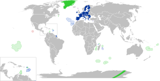
English:
European Union
Outermost regions
Overseas countries and territories
Special cases
Other special territories Français : Union européenne
Régions ultrapériphériques
Pays et territoires d'outre-mer
Cas spéciaux
Autres territoires spéciaux |
| Datum | |
| Zdroj | Vlastní dílo |
| Autor | Glentamara |
| SVG vývoj | Tento vektorový obrázek byl vytvořen programem Inkscape, or with something else. |
Licence
| Já, autor tohoto díla, jej tímto uvolňuji jako volné dílo, a to celosvětově. V některých zemích to není podle zákona možné; v takovém případě: Poskytuji komukoli právo užívat toto dílo za libovolným účelem, a to bezpodmínečně s výjimkou podmínek vyžadovaných zákonem. |
Historie souboru
Kliknutím na datum a čas se zobrazí tehdejší verze souboru.
| Datum a čas | Náhled | Rozměry | Uživatel | Komentář | |
|---|---|---|---|---|---|
| současná | 8. 6. 2022, 21:12 | | 512 × 258 (835 KB) | Nablicus | new version |
| 17. 7. 2020, 12:13 |  | 512 × 259 (736 KB) | Alcaios | fixed – those were models I use to check the scale | |
| 17. 7. 2020, 01:03 |  | 512 × 258 (672 KB) | Nablicus | Reverted to version as of 19:08, 16 July 2020 (UTC). There is an extra UK and Iceland in the middle of Canada... | |
| 16. 7. 2020, 21:53 |  | 512 × 259 (753 KB) | Alcaios | frame | |
| 16. 7. 2020, 21:50 |  | 512 × 258 (681 KB) | Alcaios | minor fixed on Greenland mar. zone | |
| 16. 7. 2020, 21:46 |  | 512 × 258 (681 KB) | Alcaios | Added maritime zone of Gree,land based on https://www.marineregions.org/eezdetails.php?mrgid=8438 | |
| 16. 7. 2020, 21:32 |  | 512 × 259 (752 KB) | Alcaios | added Faroe Islands' maritime zone | |
| 16. 7. 2020, 21:08 |  | 512 × 258 (672 KB) | Alcaios | Maritime zones in the eastern Caribbean at the right scale, with the help of https://commons.wikimedia.org/wiki/File:Caribbean_maritime_boundaries_map.svg | |
| 16. 7. 2020, 20:44 |  | 512 × 259 (742 KB) | Alcaios | slight realignments | |
| 16. 7. 2020, 20:38 |  | 512 × 259 (742 KB) | Alcaios | typo in previous edit, read: "Northern Cyprus is not a special member state territory since..." –– the Åland archipelago is larger and almost reaches the Finnish coast |
Využití souboru
Tento soubor používají následující 3 stránky:
Globální využití souboru
Tento soubor využívají následující wiki:
- Využití na ar.wikipedia.org
- Využití na br.wikipedia.org
- Využití na de.wikipedia.org
- Využití na en.wikipedia.org
- European Union
- Neocolonialism
- Outline of the European Union
- Special territories of members of the European Economic Area
- Potential enlargement of the European Union
- External border of the European Union
- User:Falcaorib
- User:Xicomaia/sandbox
- User:Spinykitsune65/sandbox2
- User:A diehard editor/sandbox/EU infobox
- Využití na fa.wikipedia.org
- Využití na fr.wikipedia.org
- Aruba
- Ceuta
- Polynésie française
- Groenland
- Açores
- Saint-Pierre-et-Miquelon
- Îles Canaries
- Madère
- Îles Kerguelen
- Île Clipperton
- Îles Féroé
- Région ultrapériphérique
- Îles Éparses de l'océan Indien
- Curaçao
- Åland
- Melilla
- Archipel Crozet
- Terre Adélie
- Bonaire
- Saba
- Saint-Eustache (Antilles)
- Peñón de Vélez de la Gomera
- Peñón de Alhucemas
- Îles Saint-Paul et Amsterdam
- Plazas de soberanía
- Nouvelle-Calédonie
- Saint-Martin (royaume des Pays-Bas)
- Saint-Martin (Antilles françaises)
- Pays et territoire d'outre-mer
- Saint-Barthélemy (Antilles françaises)
- Union européenne
- États membres de l'Union européenne
- Terres australes et antarctiques françaises
- Pays-Bas caribéens
- Wallis-et-Futuna
- Territoires associés à l'Union européenne
Zobrazit další globální využití tohoto souboru.