Soubor:Naval Bombardments on D-Day.png
Velikost tohoto náhledu: 800 × 541 pixelů. Jiná rozlišení: 320 × 216 pixelů | 640 × 433 pixelů | 1 024 × 692 pixelů | 1 498 × 1 013 pixelů.
Původní soubor (1 498 × 1 013 pixelů, velikost souboru: 3,27 MB, MIME typ: image/png)
| Tento soubor pochází z Wikimedia Commons. Níže jsou zobrazeny informace, které obsahuje jeho tamější stránka s popisem souboru. |
Popis
| Popis |
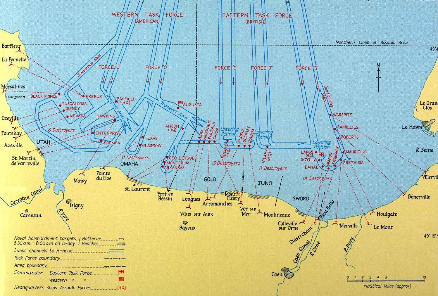
Naval Bombardments on D-Day |
|||||||||
| Datum | HMSO 1962 | |||||||||
| Zdroj | http://www.nationalarchives.gov.uk/battles/dday/popup/naval.htm | |||||||||
| Tvůrce |
HM Government. Post-Work: User:W.wolny |
|||||||||
| Svolení (Užití tohoto souboru) |
|
|||||||||
| Geotemporal data | ||||||||||
| Map location | Normandy | |||||||||
| Bounding box |
|
|||||||||
| Georeferencing | ||||||||||

Historie souboru
Kliknutím na datum a čas se zobrazí tehdejší verze souboru.
| Datum a čas | Náhled | Rozměry | Uživatel | Komentář | |
|---|---|---|---|---|---|
| současná | 17. 7. 2005, 14:06 | | 1 498 × 1 013 (3,27 MB) | W.wolny |
Využití souboru
Tento soubor používá následující stránka:
Globální využití souboru
Tento soubor využívají následující wiki:
- Využití na da.wikipedia.org
- Využití na de.wikipedia.org
- Využití na de.wikibooks.org
- Využití na en.wikipedia.org
- Využití na et.wikipedia.org
- Využití na fi.wikipedia.org
- Využití na fr.wikipedia.org
- Omaha Beach
- Opération Tonga
- Plages du débarquement allié en Normandie
- Batterie de Longues-sur-Mer
- Wikipédia:Le Bistro/6 juin 2010
- Wikipédia:Le Bistro/Galerie/2010
- Opérations navales pendant la bataille de Normandie
- Wikipédia:Le Bistro/Galerie/Juin
- Mémorial britannique de Normandie
- Ordre de bataille du débarquement de Normandie
- Využití na hu.wikipedia.org
- Využití na it.wikipedia.org
- Využití na ka.wikipedia.org
- Využití na ko.wikipedia.org
- Využití na pt.wikipedia.org
- Využití na ru.wikipedia.org
- Využití na sk.wikipedia.org
- Využití na vi.wikipedia.org