Soubor:ElectoralCollege2016.svg

Původní soubor (soubor SVG, nominální rozměr: 1 020 × 593 pixelů, velikost souboru: 30 KB)
| Tento soubor pochází z Wikimedia Commons. Níže jsou zobrazeny informace, které obsahuje jeho tamější stránka s popisem souboru. |
| U.S. presidential election maps (SVG) |
| See also: National Atlas maps (png) |
|
1789 · 1792 · 1796 · 1800 · 1804 · 1808 · 1812 · 1816 · 1820 · 1824 · 1828 · 1832 · 1836 · 1840 · 1844 · 1848 · 1852 · 1856 · 1860 · 1864 · 1868 · 1872 · 1876 · 1880 · 1884 · 1888 · 1892 · 1896 · 1900 · 1904 · 1908 · 1912 · 1916 · 1920 · 1924 · 1928 · 1932 · 1936 · 1940 · 1944 · 1948 · 1952 · 1956 · 1960 · 1964 · 1968 · 1972 · 1976 · 1980 · 1984 · 1988 · 1992 · 1996 · 2000 · 2004 · 2008 · 2012 · 2016 · 2020 · 2024 |
Popis
| Popis |
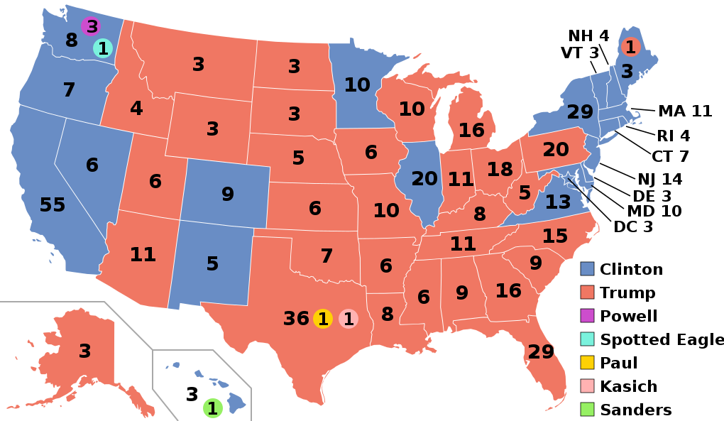
English: Electoral college map for the 2016 United States presidential election (note: Nebraska and Maine split their EVs by congressional district). |
||||
| Datum | |||||
| Zdroj | 2012 Electoral College map | ||||
| Autor | Gage | ||||
| Další verze |
|
||||
| SVG vývoj | Tento vektorový obrázek byl vytvořen textovým editorem. This map uses embedded text. |

.svg)


.svg)
.svg)


Licence
- Dílo smíte:
- šířit – kopírovat, distribuovat a sdělovat veřejnosti
- upravovat – pozměňovat, doplňovat, využívat celé nebo částečně v jiných dílech
- Za těchto podmínek:
- uveďte autora – Máte povinnost uvést autorství, poskytnout odkaz na licenci a uvést, pokud jste provedli změny. Toho můžete docílit jakýmkoli rozumným způsobem, avšak ne způsobem naznačujícím, že by poskytovatel licence schvaloval nebo podporoval vás nebo vaše užití díla.
- zachovejte licenci – Pokud tento materiál jakkoliv upravíte, přepracujete nebo použijete ve svém díle, musíte své příspěvky šířit pod stejnou nebo slučitelnou licencí jako originál.
Historie souboru
Kliknutím na datum a čas se zobrazí tehdejší verze souboru.
| Datum a čas | Náhled | Rozměry | Uživatel | Komentář | |
|---|---|---|---|---|---|
| současná | 27. 11. 2020, 05:22 | | 1 020 × 593 (30 KB) | Politicsfan4 | Updated placement of ME-2's electoral vote for consistency with 2020 map |
| 5. 8. 2020, 03:22 |  | 1 020 × 593 (30 KB) | Nojus R | Reverted to version as of 07:42, 13 January 2019 (UTC) it looks so weird when every other map uses a different font | |
| 10. 12. 2019, 21:31 |  | 1 020 × 593 (30 KB) | IagoQnsi | switching font to Arial, as it looks less-ugly in the server-side rendering // Editing SVG source code using c:User:Rillke/SVGedit.js | |
| 13. 1. 2019, 09:42 |  | 1 020 × 593 (30 KB) | Newfraferz87 | (minor) | |
| 20. 11. 2018, 04:50 |  | 1 020 × 593 (30 KB) | Newfraferz87 | *DC | |
| 20. 11. 2018, 04:35 |  | 1 020 × 593 (30 KB) | Newfraferz87 | Simplify further: coordinates & fills, following this | |
| 18. 1. 2017, 16:16 |  | 1 020 × 593 (36 KB) | Newfraferz87 | Shrink size using relative line coordinates. Thanks for the border corrections. | |
| 17. 1. 2017, 11:20 |  | 1 020 × 593 (43 KB) | Karlfk | Better borderlines, esp. OH/WV/PA triangle or ID/MT border | |
| 12. 1. 2017, 05:14 |  | 1 020 × 593 (36 KB) | PalmerTheGolfer | Reverted to version as of 00:56, 3 January 2017 (UTC) Font of numbers and State line consistency with prior elections more important than a non-existent Libretarian faithless elector change | |
| 11. 1. 2017, 00:50 |  | 1 020 × 593 (36 KB) | Maproom | Changed font to Liberation Sans, in the hope of avoiding the problem of "Eagle" extending off the end of the image |
.svg)
Využití souboru
Tento soubor používají následující 2 stránky:
Globální využití souboru
Tento soubor využívají následující wiki:
- Využití na af.wikipedia.org
- Využití na ang.wikipedia.org
- Využití na ar.wikipedia.org
- Využití na arz.wikipedia.org
- Využití na be.wikipedia.org
- Využití na bg.wikipedia.org
- Využití na bn.wikipedia.org
- Využití na bs.wikipedia.org
- Využití na ca.wikipedia.org
- Využití na cdo.wikipedia.org
- Využití na cy.wikipedia.org
- Využití na da.wikipedia.org
- Využití na de.wikipedia.org
- Využití na dty.wikipedia.org
- Využití na el.wikipedia.org
- Využití na en.wikipedia.org
- Donald Trump
- Electoral vote changes between United States presidential elections
- List of United States presidential election results by state
- Presidency of Barack Obama
- 2016 United States presidential election
- United States presidential election
- 2016 Democratic Party presidential candidates
- 2016 Democratic Party presidential primaries
- 2016 Republican Party presidential candidates
- 2016 Republican Party presidential primaries
- Third party and independent candidates for the 2016 United States presidential election
- 2016 United States elections
- User:ArcMachaon/sandbox
- User:Mandruss/sandbox
- User:Visigoethe/sandbox
- User:Machinekng/sandbox
- Donald Trump 2016 presidential campaign
- 2016 New Hampshire Republican presidential primary
Zobrazit další globální využití tohoto souboru.