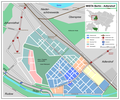
Soubor:Wista-adlershof.png

Velikost tohoto náhledu: 719 × 600 pixelů. Jiná rozlišení: 288 × 240 pixelů | 576 × 480 pixelů | 921 × 768 pixelů | 1 228 × 1 024 pixelů | 2 456 × 2 048 pixelů | 3 415 × 2 848 pixelů.
Původní soubor (3 415 × 2 848 pixelů, velikost souboru: 626 KB, MIME typ: image/png)
Historie souboru
Kliknutím na datum a čas se zobrazí tehdejší verze souboru.
| Datum a čas | Náhled | Rozměry | Uživatel | Komentář | |
|---|---|---|---|---|---|
| současná | 19. 6. 2007, 14:51 |  | 3 415 × 2 848 (626 KB) | Fremantleboy | |
| 19. 6. 2007, 12:13 |  | 3 415 × 2 848 (623 KB) | Fremantleboy | SVG-Version Image:Wista-adlershof.svg == Beschreibung == {{Information |Description=de: Karte der Wissenschaftsstadt WISTA Berlin - Adlershof / en: Map of Scientific City "WISTA", Berlin - Adlershof |Source=own work / selbst hergestellt, Informations | |
| 19. 6. 2007, 11:58 |  | 3 415 × 2 848 (611 KB) | Fremantleboy | SVG-Version: :Image:Wista-adlershof.SVG == Beschreibung == {{Information |Description=de: Karte der Wissenschaftsstadt WISTA Berlin - Adlershof / en: Map of Scientific City "WISTA", Berlin - Adlershof |Source=own work / selbst hergestellt, Informations: | |
| 19. 6. 2007, 06:42 |  | 3 415 × 2 848 (618 KB) | Fremantleboy | == Beschreibung == {{Information |Description=de: Karte der Wissenschaftsstadt WISTA Berlin - Adlershof / en: Map of Scientific City "WISTA", Berlin - Adlershof |Source=own work / selbst hergestellt, Informations: Google Earth, maps of Wista Management |D | |
| 19. 6. 2007, 04:55 |  | 3 415 × 2 848 (581 KB) | Fremantleboy | == Beschreibung == {{Information |Description=de: Karte der Wissenschaftsstadt WISTA Berlin - Adkershof |Source=own work / selbst hergestellt |Date=18.06.2007 |Author= Fremantleboy 04:55, 19 June 2007 (UTC) |other_versions= }} == Li |
Využití souboru
Tento soubor používá následující stránka:
Globální využití souboru
Tento soubor využívají následující wiki:
- Využití na de.wikipedia.org
- Využití na en.wikipedia.org
- Využití na www.wikidata.org

