Soubor:Volcanoes of Western Isabela.jpg
Větší rozlišení není k dispozici
Volcanoes_of_Western_Isabela.jpg (631 × 480 pixelů, velikost souboru: 99 KB, MIME typ: image/jpeg)
| Tento soubor pochází z Wikimedia Commons. Níže jsou zobrazeny informace, které obsahuje jeho tamější stránka s popisem souboru. |
Popis
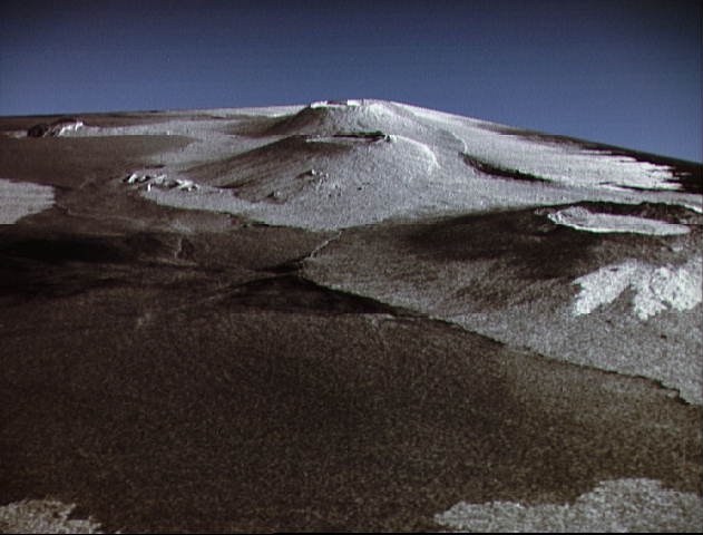
| Popis |
English: This is a three dimensional perspective view of Isla Isabela in the western Galapagos Islands. It was taken by the L-band radar in HH polarization from the Spaceborne Imaging Radar-C/X-Band Synthetic Aperature Radar on the 40th orbit of the Shuttle Endeavour. This view was constructed by overlaying a SIR-C radar image on a U.S. Geological Survey digital elevation map. The image is centered at about .5 degrees south latitude and 91 degrees West longitude and covers an area of 75 km by 60 km. This SIR-C/X-SAR image of Alcedo and Sierra Negra volcanoes shows the rougher lava flows as bright features, while ash deposits and smooth Pahoehoe lava flows dark. The Jet Propulsion Laboratory alternative photo number is P-43938. |
| Datum | |
| Zdroj | www.nasaimages.org |
| Autor | NASA (Space Shuttle Endeavour) |
| Další verze |
|


.jpg)
.jpg)
| Pozice fotografa | | Tento snímek a mnohé další na: OpenStreetMap |
|---|
| Pozice objektu | | Tento snímek a mnohé další na: OpenStreetMap |
|---|
Licence
| This file is in the public domain in the United States because it was solely created by NASA. NASA copyright policy states that "NASA material is not protected by copyright unless noted". (See Template:PD-USGov, NASA copyright policy page or JPL Image Use Policy.) | ||
 |
Warnings:
|
Historie souboru
Kliknutím na datum a čas se zobrazí tehdejší verze souboru.
| Datum a čas | Náhled | Rozměry | Uživatel | Komentář | |
|---|---|---|---|---|---|
| současná | 4. 5. 2010, 23:36 | | 631 × 480 (99 KB) | Dr Brains | {{Information |Description={{en|1=This is a three dimensional perspective view of Isla Isabela in the western Galapagos Islands. It was taken by the L-band radar in HH polarization from the Spaceborne Imaging Radar-C/X-Band Synthetic Aperature Radar on th |
Využití souboru
Tento soubor používají následující 2 stránky:
Globální využití souboru
Tento soubor využívají následující wiki:
- Využití na en.wikipedia.org
- Využití na fr.wikipedia.org
- Využití na it.wikipedia.org
- Využití na ja.wikipedia.org
- Využití na sk.wikipedia.org