Soubor:US Northeastern states.png

Velikost tohoto náhledu: 800 × 520 pixelů. Jiná rozlišení: 320 × 208 pixelů | 640 × 416 pixelů | 1 024 × 665 pixelů | 1 513 × 983 pixelů.
Původní soubor (1 513 × 983 pixelů, velikost souboru: 46 KB, MIME typ: image/png)
| Tento soubor pochází z Wikimedia Commons. Níže jsou zobrazeny informace, které obsahuje jeho tamější stránka s popisem souboru. |
Popis
| Popis |
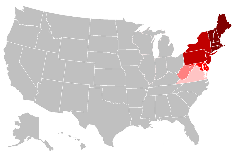
English: Map of the northeastern United States. The pink areas include states that are cited by fewer reliable sources as being included in the Northeast. The red areas are more frequently cited by reliable sources, and the dark red are the most commonly accepted as being included in the Northeast. |
| Datum | |
| Zdroj | Vlastní dílo, File:BlankMap-USA-states.PNG |
| Autor | Grayshi, Roke, Maher-shalal-hashbaz |
Licence
Já, držitel autorských práv k tomuto dílu, ho tímto zveřejňuji za podmínek následujících licencí:
Tento soubor podléhá licenci Creative Commons Uveďte autora-Zachovejte licenci 3.0 Unported
- Dílo smíte:
- šířit – kopírovat, distribuovat a sdělovat veřejnosti
- upravovat – pozměňovat, doplňovat, využívat celé nebo částečně v jiných dílech
- Za těchto podmínek:
- uveďte autora – Máte povinnost uvést autorství, poskytnout odkaz na licenci a uvést, pokud jste provedli změny. Toho můžete docílit jakýmkoli rozumným způsobem, avšak ne způsobem naznačujícím, že by poskytovatel licence schvaloval nebo podporoval vás nebo vaše užití díla.
- zachovejte licenci – Pokud tento materiál jakkoliv upravíte, přepracujete nebo použijete ve svém díle, musíte své příspěvky šířit pod stejnou nebo slučitelnou licencí jako originál.

|
Tento dokument smí být kopírován, šířen nebo upravován podle podmínek Svobodné licence GNU pro dokumenty verze 1.2 nebo libovolné vyšší verze publikované nadací Free Software Foundation. Dokument nemá neměnné části ani texty na předním či zadním přebalu. Kopie textu licence je k dispozici v oddíle nazvaném GNU Free Documentation License. |
Můžete si zvolit libovolnou z těchto licencí.
Historie souboru
Kliknutím na datum a čas se zobrazí tehdejší verze souboru.
| Datum a čas | Náhled | Rozměry | Uživatel | Komentář | |
|---|---|---|---|---|---|
| současná | 26. 4. 2018, 01:19 | | 1 513 × 983 (46 KB) | Swarm | The Bureau of Prisons by itself is not sufficient to support Ohio being geographically classified as NE |
| 6. 2. 2016, 21:39 |  | 1 513 × 983 (31 KB) | Hoppingalong | Mean to revert back to this map by Maher-shalal-hashbaz | |
| 6. 2. 2016, 21:38 |  | 1 513 × 983 (36 KB) | Hoppingalong | Reverted to version as of 21:29, 5 May 2014 (UTC) - This is consistent with the article it illustrates. | |
| 15. 8. 2015, 05:54 |  | 1 513 × 983 (46 KB) | Swarm | Removing Midwestern states. The source behind the inclusion and the weight given to the concept of these states being "Northeastern" are dubious at best and contradict the general body of reliable sources. | |
| 5. 5. 2014, 23:56 |  | 1 513 × 983 (36 KB) | KenHigh | I keep trying to upload a new version and the new version appears in wiki properly, but when I upload it wiki shows the old version. The new version shows Wisconsin, Illinois, Michigan and Indiana in light pink, but when I upload it it shows them in gr... | |
| 5. 5. 2014, 23:32 |  | 1 513 × 983 (36 KB) | KenHigh | Added new version of map showing Wisconsin, Illinois, Michigan and Indiana as states which are sometimes included in alternative definitions of the Northeast as stated and referenced in other parts of the article. | |
| 5. 5. 2014, 23:29 |  | 1 513 × 983 (36 KB) | KenHigh | Added Wisconsin, Michigan, Illinois and Indiana in light pink to indicate that these states are also sometimes included in definitions of the Northeast as stated and referneced by other sections of this article. | |
| 25. 9. 2013, 16:55 |  | 1 513 × 983 (31 KB) | Maher-shalal-hashbaz | Added differentiation between states that are more commonly cited as Northeastern by reliable sources, and those which are less commonly cited as Northeastern by reliable sources. | |
| 14. 3. 2010, 01:23 |  | 1 513 × 983 (43 KB) | Grayshi | fix red glow | |
| 14. 3. 2010, 01:20 |  | 1 513 × 983 (69 KB) | Grayshi | cut the dark red boundary to be slightly more northern |
Využití souboru
Tento soubor nepoužívá žádná stránka.
Globální využití souboru
Tento soubor využívají následující wiki:
- Využití na ar.wikipedia.org
- Využití na ckb.wikipedia.org
- Využití na en.wikipedia.org
- Využití na fa.wikipedia.org
- Využití na it.wikipedia.org
- Využití na nl.wikipedia.org
- Využití na ur.wikipedia.org