Soubor:USGS Oregon river basins.png

Velikost tohoto náhledu: 739 × 600 pixelů. Jiná rozlišení: 296 × 240 pixelů | 591 × 480 pixelů | 946 × 768 pixelů | 1 262 × 1 024 pixelů | 1 849 × 1 501 pixelů.
Původní soubor (1 849 × 1 501 pixelů, velikost souboru: 642 KB, MIME typ: image/png)
| Tento soubor pochází z Wikimedia Commons. Níže jsou zobrazeny informace, které obsahuje jeho tamější stránka s popisem souboru. |
Popis
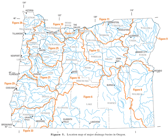
| Popis | River drainage basins in Oregon. |
| Datum | |
| Zdroj | http://pubs.usgs.gov/wdr/2005/wdr-or-05/pdf/front.pdf (page 51) |
| Autor | U.S. Geological Survey |
| Svolení (Užití tohoto souboru) |
public domain |
Licence
Tento soubor je volné dílo, protože obsahuje materiály pocházející od United States Geological Survey (USGS), agentury Ministerstva vnitra USA. Pro bližší informaci vizte oficiální licenční pravidla USGS (anglicky).
|
Historie souboru
Kliknutím na datum a čas se zobrazí tehdejší verze souboru.
| Datum a čas | Náhled | Rozměry | Uživatel | Komentář | |
|---|---|---|---|---|---|
| současná | 10. 2. 2013, 21:52 | | 1 849 × 1 501 (642 KB) | Kmusser | Baker City correction |
| 10. 11. 2011, 19:55 |  | 1 849 × 1 501 (433 KB) | Finetooth | Corrected my correction of the Grants Pass location. It is a bit further south than I had it on the second version. | |
| 10. 11. 2011, 04:54 |  | 1 849 × 1 501 (433 KB) | Finetooth | Corrected location of Grants Pass, which is on the Rogue River between the Jackson–Josephine county border and the mouth of the Applegate River. | |
| 16. 10. 2006, 21:32 |  | 1 849 × 1 501 (723 KB) | EncMstr | {{Information |Description=River drainage basins in Oregon |Source= http://pubs.usgs.gov/wdr/2005/wdr-or-05/pdf/front.pdf page 82 |Date=2006-03-31 |Author=w:USGS |Permission=public domain }} category:Maps of Oregon [[category:Maps of rivers of the |
Využití souboru
Tento soubor používá následující stránka:
Globální využití souboru
Tento soubor využívají následující wiki:
- Využití na bg.wikipedia.org
- Využití na en.wikipedia.org
- Využití na hu.wikipedia.org
- Využití na it.wikipedia.org
- Využití na nl.wikipedia.org
- Využití na ru.wikipedia.org
- Využití na vi.wikipedia.org