Soubor:Toutle River in flood.jpg

Velikost tohoto náhledu: 800 × 529 pixelů. Jiná rozlišení: 320 × 211 pixelů | 640 × 423 pixelů | 1 024 × 677 pixelů | 1 500 × 991 pixelů.
Původní soubor (1 500 × 991 pixelů, velikost souboru: 1,14 MB, MIME typ: image/jpeg)
| Tento soubor pochází z Wikimedia Commons. Níže jsou zobrazeny informace, které obsahuje jeho tamější stránka s popisem souboru. |
| Popis |
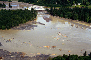
English: The mouth of the Toutle River in flood near Castle Rock, Washington. The Interstate-5 bridge is in the background. The photo was taken prior to the 1980 eruption of Mt. St. Helens. |
|||
| Umístění | Castle Rock, Cowlitz County, Washington, USA 46°18′37.3″N 122°55′1.71″W / 46.310361°N 122.9171417°W |
|||
| Datum | ||||
| Zdroj |
U.S. Army Corps of Engineers Digital Visual Library Image page Image description page Digital Visual Library home page |
|||
| Autor | Bob Heims, U.S. Army Corps of Engineers | |||
| Svolení (Užití tohoto souboru) |
|
Historie souboru
Kliknutím na datum a čas se zobrazí tehdejší verze souboru.
| Datum a čas | Náhled | Rozměry | Uživatel | Komentář | |
|---|---|---|---|---|---|
| současná | 18. 3. 2007, 18:47 | | 1 500 × 991 (1,14 MB) | DanMS | {{Information | Description = The mouth of the Toutle River in flood near Castle Rock, Washington. The Interstate-5 bridge is in the background. The photo was taken prior to the 1980 eruption of Mt. St. Helens. | Source = U.S. Army Corps of Engineers |
Využití souboru
Tento soubor používá následující stránka:
Globální využití souboru
Tento soubor využívají následující wiki:
- Využití na en.wikipedia.org
- Využití na fr.wikipedia.org
- Využití na ru.wikipedia.org