Soubor:Tlaxcalamap.jpg
Původní soubor (3 840 × 3 000 pixelů, velikost souboru: 2,24 MB, MIME typ: image/jpeg)
| Tento soubor pochází z Wikimedia Commons. Níže jsou zobrazeny informace, které obsahuje jeho tamější stránka s popisem souboru. |
Popis
| Popis |
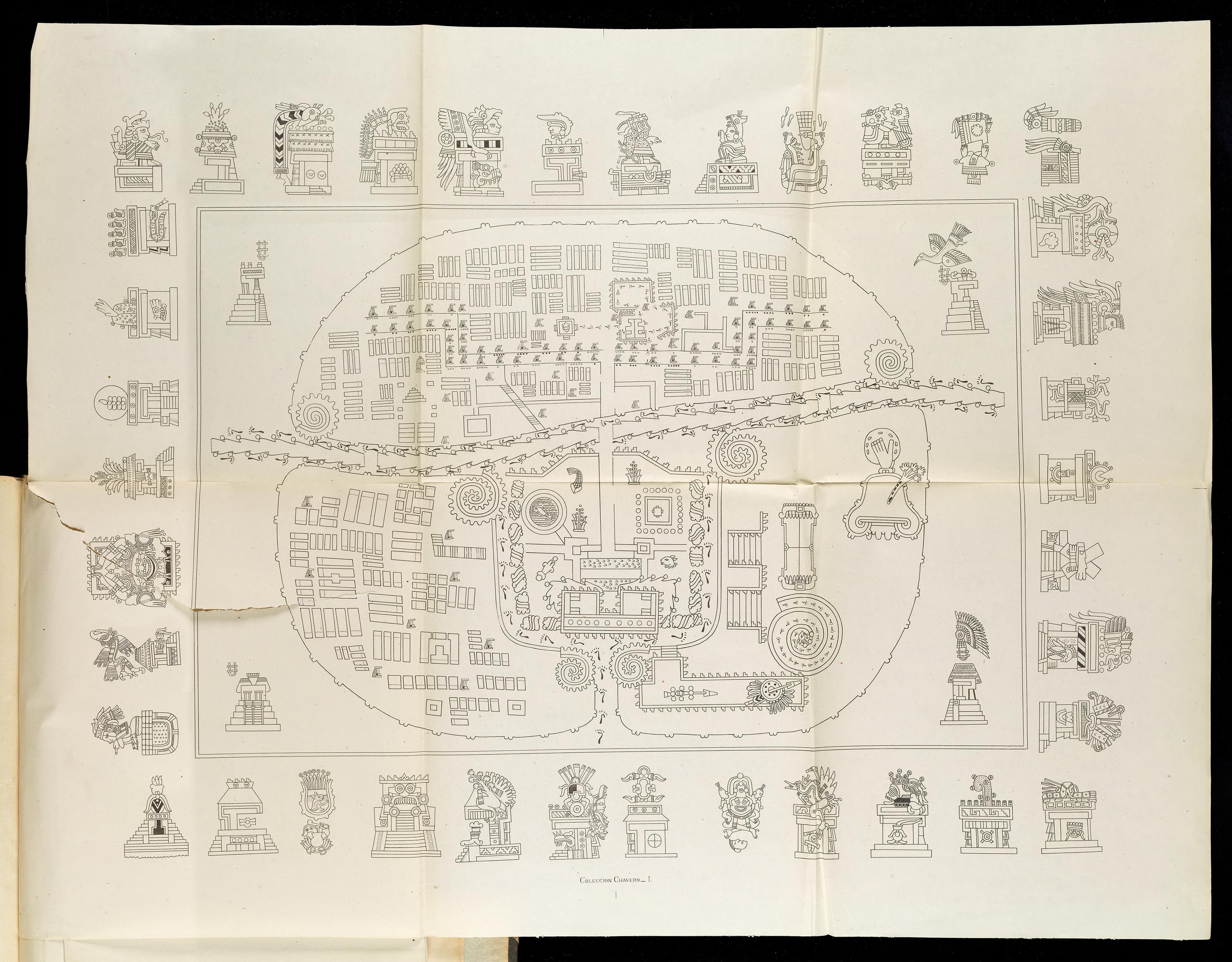
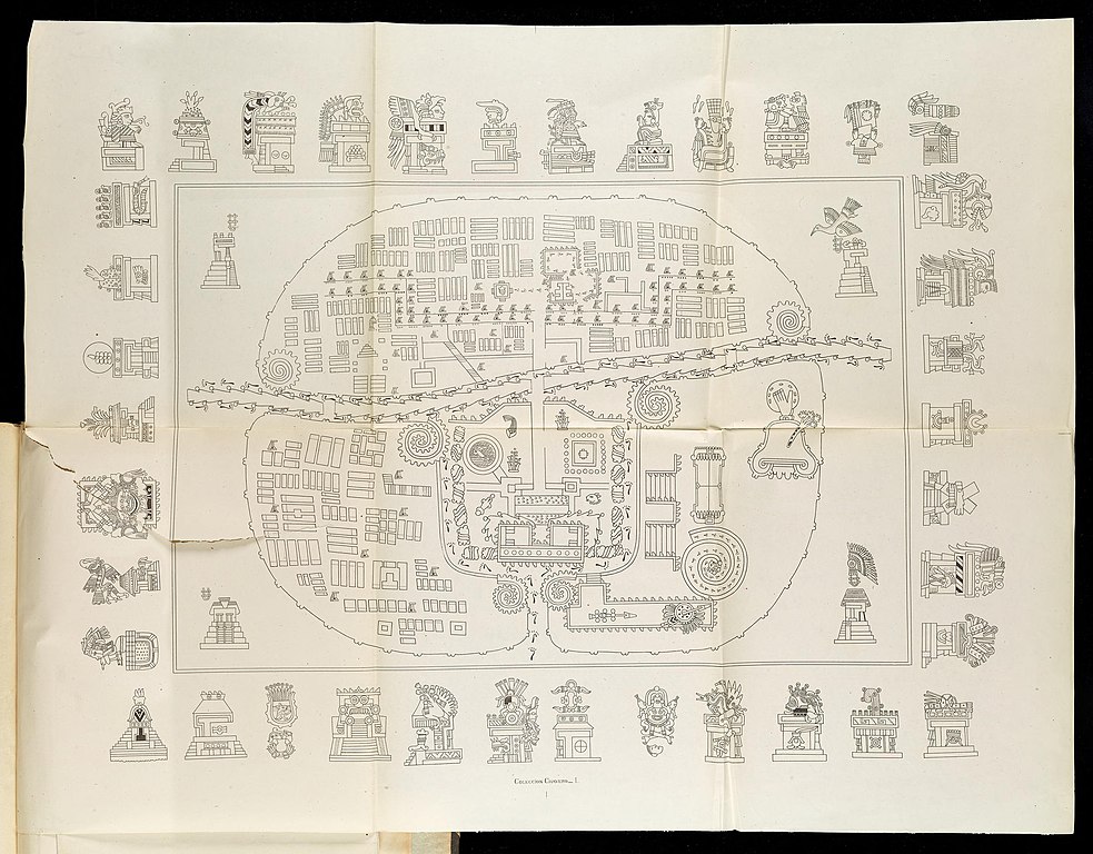
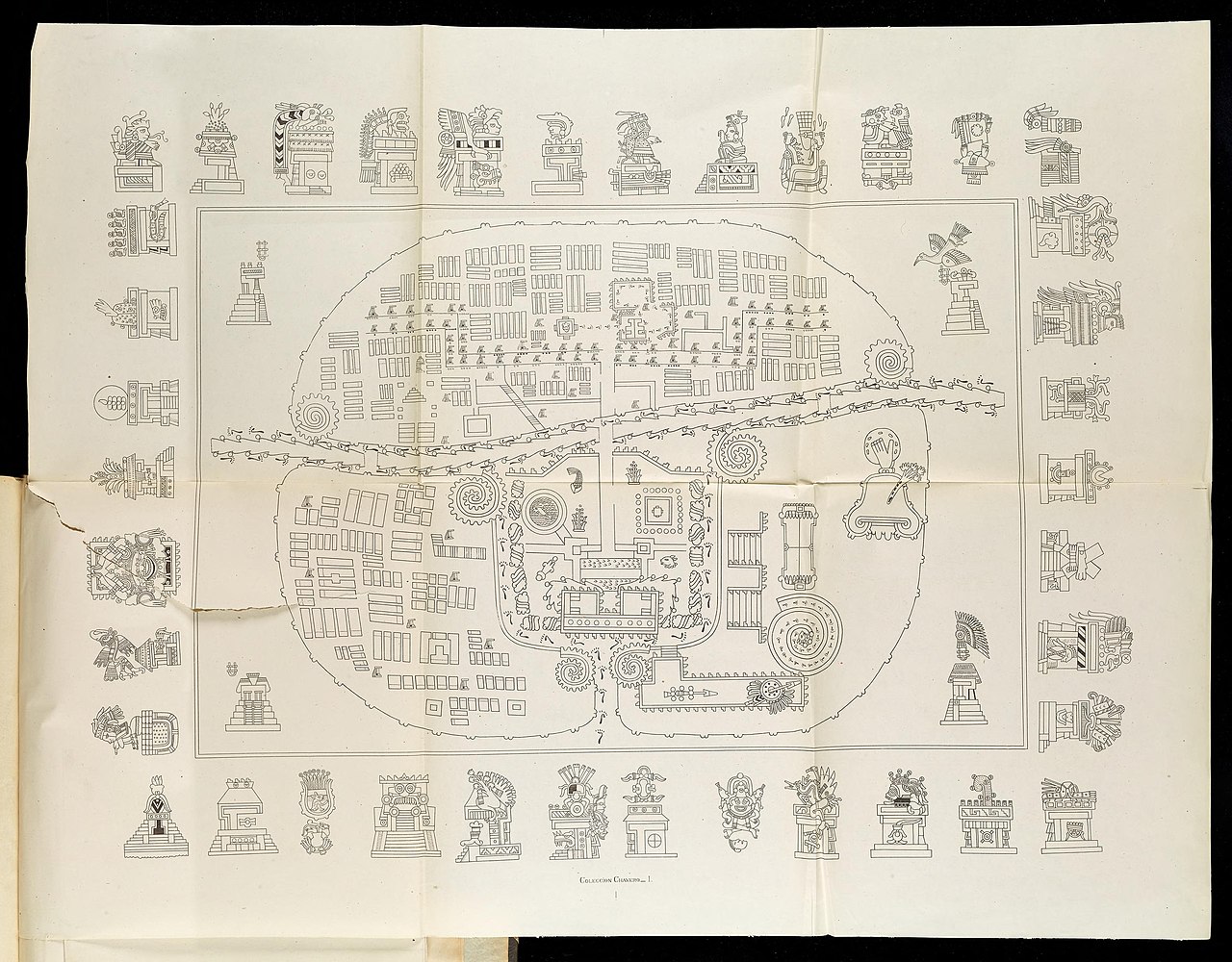
English: A Map of Tlaxcala: The top-right hand sector is Tizatlan, the bottom-right hand sector Quiahuiztlan, the top-left hand sector Ocotelolco, and the bottom-left hand sector Tepeticpac. The river, Atzompa, crosses the city from North to South (left to right, the map being oriented along an East-West axis).
Italiano: Mappa di Tlaxcala.Il settore in alto a destra è Tizatlan, quello in basso a destra è Quiahuiztlan, quello in alto a sinistra è Ocotelolco e quello in basso a sinistra è Tepeticpac. Il fiume, Atzompa, attraversa la città da nord a sud (da sinistra a destra, dato che la mappa è orientata sull'asse est-ovest). Tratta da Alfredo Chavero, Pintures Jeroglificas, Messico, 1901. |
| Datum | |
| Zdroj | Pinturas Jeroglíficas, Mexico: https://archive.org/details/gri_33125009867314 |
| Autor | Alfredo Chavero |
Licence
|
Toto dílo je volné také v zemích, jejichž právní řád chrání majetková autorská práva po dobu života autora a 70 let po jeho smrti.
| |
| Bylo zjištěno, že u tohoto souboru nejsou známa žádná omezení daná autorským právem a právy s ním souvisejícími. | |
Původní historie souboru
- 2009-07-06 03:43 Robert M Johnson 871×663× (693169 bytes) == Description == {{Information |Description= Map of the [[Nahuatl]] city [[Tlaxcala]] from the 20th century, |Source=Originally from [http://books.google.com/books?id=o-sMQAovYJoC&pg=PA461&lpg=PA461&dq=Tepeticpac+tlaxcala&source=bl&ots=1y1yM9xzIM&sig=u6
Historie souboru
Kliknutím na datum a čas se zobrazí tehdejší verze souboru.
| Datum a čas | Náhled | Rozměry | Uživatel | Komentář | |
|---|---|---|---|---|---|
| současná | 17. 6. 2022, 11:50 | | 3 840 × 3 000 (2,24 MB) | ErickTErick | Better version from the same source |
| 21. 11. 2009, 16:08 |  | 871 × 663 (677 KB) | File Upload Bot (Magnus Manske) | {{BotMoveToCommons|en.wikipedia|year={{subst:CURRENTYEAR}}|month={{subst:CURRENTMONTHNAME}}|day={{subst:CURRENTDAY}}}} {{Information |Description={{en|''no original description''}} |Source=Transferred from [http://en.wikipedia.org en.wikipedia]; transfer |
Využití souboru
Tento soubor používá následující stránka:
Globální využití souboru
Tento soubor využívají následující wiki:
- Využití na af.wikipedia.org
- Využití na arz.wikipedia.org
- Využití na ca.wikipedia.org
- Využití na en.wikipedia.org
- Využití na eo.wikipedia.org
- Využití na es.wikipedia.org
- Využití na it.wikipedia.org
- Využití na ja.wikipedia.org
- Využití na pl.wikipedia.org
- Využití na uk.wikipedia.org
- Využití na www.wikidata.org