Soubor:Tannenberg3008.jpg
Velikost tohoto náhledu: 775 × 600 pixelů. Jiná rozlišení: 310 × 240 pixelů | 620 × 480 pixelů | 993 × 768 pixelů | 1 242 × 961 pixelů.
Původní soubor (1 242 × 961 pixelů, velikost souboru: 207 KB, MIME typ: image/jpeg)
| Tento soubor pochází z Wikimedia Commons. Níže jsou zobrazeny informace, které obsahuje jeho tamější stránka s popisem souboru. |

|
K tomuto obrázku existuje vektorová verze (v SVG). Pokud je lepší, používejte raději tu.
File:Tannenberg3008.jpg → File:East Prussian Campaign (27—30 Aug 1914) - ru.svg
Podrobnější informace o vektorové grafice najdete na stránce Commons:Transition to SVG. Také si můžete přečíst informace o podpoře formátu SVG v MediaWiki. |
_-_ru.svg) |
| Popis |
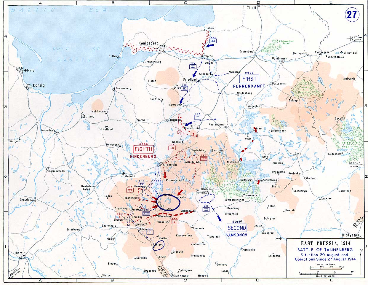
English: Battle of Tannenberg (1914) in its last phase |
| Zdroj |
Taken from the campaign series, made public by the US-Army under dean.usma.edu
|
| Autor | US-Army under www.dean.usma.edu |
| Svolení (Užití tohoto souboru) |
The picture is public domain. |
Tento obrázek nebo soubor je dílem zaměstnance Armády Spojených států amerických pořízeným nebo vytvořeným během výkonu oficiálních povinností. Jako dílo federální vlády USA je tento obrázek nebo soubor volným dílem.
|
 |
Historie souboru
Kliknutím na datum a čas se zobrazí tehdejší verze souboru.
| Datum a čas | Náhled | Rozměry | Uživatel | Komentář | |
|---|---|---|---|---|---|
| současná | 22. 9. 2005, 16:29 | | 1 242 × 961 (207 KB) | Nasiruddin | Taken from the campaign series, made public by the US-Army under www.dean.usma.edu The öpicture is public domain. It shows the battle of Tannenberg in its last phase {{PD-USGov-Military-Army}} Category:World War I maps |
Využití souboru
Tento soubor používají následující 2 stránky:
Globální využití souboru
Tento soubor využívají následující wiki:
- Využití na be-tarask.wikipedia.org
- Využití na be.wikipedia.org
- Využití na ca.wikipedia.org
- Využití na da.wikipedia.org
- Využití na de.wikipedia.org
- Využití na el.wikipedia.org
- Využití na en.wikipedia.org
- Využití na et.wikipedia.org
- Využití na fi.wikipedia.org
- Využití na fr.wikipedia.org
- Využití na he.wikipedia.org
- Využití na hr.wikipedia.org
- Využití na it.wikipedia.org
- Využití na ja.wikipedia.org
- Využití na ko.wikipedia.org
- Využití na lv.wikipedia.org
- Využití na nl.wikipedia.org
- Využití na no.wikipedia.org
- Využití na pl.wikipedia.org
- Využití na sv.wikipedia.org
- Využití na uk.wikipedia.org
- Využití na vi.wikipedia.org
- Využití na zh.wikipedia.org