Soubor:Super Pit Mine, Kalgoorlie, Western Australia.jpg

Velikost tohoto náhledu: 600 × 600 pixelů. Jiná rozlišení: 240 × 240 pixelů | 480 × 480 pixelů | 768 × 768 pixelů | 1 024 × 1 024 pixelů | 2 048 × 2 048 pixelů | 3 000 × 3 000 pixelů.
Původní soubor (3 000 × 3 000 pixelů, velikost souboru: 3,46 MB, MIME typ: image/jpeg)
| Tento soubor pochází z Wikimedia Commons. Níže jsou zobrazeny informace, které obsahuje jeho tamější stránka s popisem souboru. |
Popis
| Popis |
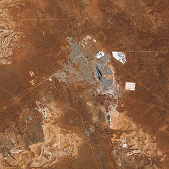
English: The pit that gives the mine its name appears in the centre of the image, and some of the steep pit’s walls appear in shadow while others are illuminated by the Sun. Related mining operations form a rough semicircle on the eastern side of the pit; a cluster of buildings east-north-east of the pit is Fimiston Mill, where ore is processed. Waste dumps and grey-white tailings ponds sprawl over the arid landscape. Tailings are the rocks and chemicals left over after the gold is extracted. Because the chemicals used to separate gold from rock are often caustic, tailings usually pose hazards to human and/or environmental health and must be treated carefully. The metropolitan area of Kalgoorlie, marked by street grids and manicured green spaces, extends almost to the mine’s central pit. An airport, marked by a long runway, appears along the city’s southern margin. Founded during a late-nineteenth-century gold rush, Kalgoorlie, like the neighboring mine, occurs near an area nicknamed the “Golden Mile,” which is considered especially rich in gold deposits. As the beige and reddish colors in the image indicate, vegetation in the area is sparse. |
| Datum | |
| Zdroj | NASA Earth Observatory |
| Autor | Jesse Allen |
Image captured by the Advanced Land Imager (ALI) on NASA’s Earth Observing-1 (EO-1) satellite. Data provided courtesy of the NASA EO-1 team.
Licence
| This file is in the public domain in the United States because it was solely created by NASA. NASA copyright policy states that "NASA material is not protected by copyright unless noted". (See Template:PD-USGov, NASA copyright policy page or JPL Image Use Policy.) | ||
 |
Warnings:
|
| Poznámky | K tomuto souboru existují poznámky: Prohlédnout si poznámky na Commons |
Historie souboru
Kliknutím na datum a čas se zobrazí tehdejší verze souboru.
| Datum a čas | Náhled | Rozměry | Uživatel | Komentář | |
|---|---|---|---|---|---|
| současná | 22. 2. 2010, 14:11 | | 3 000 × 3 000 (3,46 MB) | Originalwana | {{Information |Description={{en|1=The pit that gives the mine its name appears in the centre of the image, and some of the steep pit’s walls appear in shadow while others are illuminated by the Sun. Related mining operations form a rough semicir |
Využití souboru
Tento soubor používá následující stránka:
Globální využití souboru
Tento soubor využívají následující wiki:
- Využití na ckb.wikipedia.org
- Využití na en.wikipedia.org
- Využití na fa.wikipedia.org
- Využití na fr.wikipedia.org
- Využití na nl.wikipedia.org
- Využití na www.wikidata.org