Soubor:Suhongtu site - Sinornithomimus quarry.png

Velikost tohoto náhledu: 800 × 529 pixelů. Jiná rozlišení: 320 × 211 pixelů | 640 × 423 pixelů | 1 147 × 758 pixelů.
Původní soubor (1 147 × 758 pixelů, velikost souboru: 496 KB, MIME typ: image/png)
| Tento soubor pochází z Wikimedia Commons. Níže jsou zobrazeny informace, které obsahuje jeho tamější stránka s popisem souboru. |
Popis
| Popis |
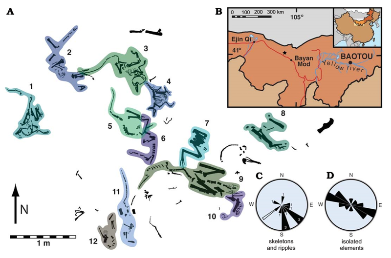
English: Suhongtu site, partial quarry map, locality map, and orientation data. A. Map of the central and northern portions of site showing the position of 12 of 13 skeletons. Skeletons 3 and 4 enlarged in Fig. 3. B. Fossil locality (41°17’ 10”N, 103°52’38”E) located 90 km northwest of Bayan Mod, InnerMongolia, China. C. Rose−diagram showing trends for skeletons (black, numbers denote skeleton count) and ripples (white). D. Mirror rose−diagram of elongated, isolated elements (n=13). Trends of skeletons have a strong, non−random (p<0.002) alignment to southeast. Flow direction of ripples is roughly perpendicular to that of elongate elements. |
| Datum | |
| Zdroj | (2008). "Mud-Trapped Herd Captures Evidence of Distinctive Dinosaur Sociality". Acta Palaeontologica Polonica 53 (4): 567–578. DOI:10.4202/app.2008.0402. ISSN 0567-7920. |
| Autor | David J. Varricchio, Paul C. Sereno, Zhao Xi-jin, Tan Lin Jeffrey A. Wilson & Gabrielle H. Lyon |
Licence
Tento soubor podléhá licenci Creative Commons Uveďte autora 4.0 International.
- Dílo smíte:
- šířit – kopírovat, distribuovat a sdělovat veřejnosti
- upravovat – pozměňovat, doplňovat, využívat celé nebo částečně v jiných dílech
- Za těchto podmínek:
- uveďte autora – Máte povinnost uvést autorství, poskytnout odkaz na licenci a uvést, pokud jste provedli změny. Toho můžete docílit jakýmkoli rozumným způsobem, avšak ne způsobem naznačujícím, že by poskytovatel licence schvaloval nebo podporoval vás nebo vaše užití díla.
Historie souboru
Kliknutím na datum a čas se zobrazí tehdejší verze souboru.
| Datum a čas | Náhled | Rozměry | Uživatel | Komentář | |
|---|---|---|---|---|---|
| současná | 21. 8. 2020, 07:28 | | 1 147 × 758 (496 KB) | PaleoNeolitic | {{Information |description ={{en|1=Suhongtu site, partial quarry map, locality map, and orientation data. '''A'''. Map of the central and northern portions of site showing the position of 12 of 13 skeletons. Skeletons 3 and 4 enlarged in Fig. 3. '''B'''. Fossil locality (41°17’ 10”N, 103°52’38”E) located 90 km northwest of Bayan Mod, InnerMongolia, China. '''C'''. Rose−diagram showing trends for skeletons (black, numbers denote skeleton count) and ripples (white). '''D'''. Mirror rose−diagr... |
Využití souboru
Tento soubor používá následující stránka:
Globální využití souboru
Tento soubor využívají následující wiki:
- Využití na ar.wikipedia.org
- Využití na ca.wikipedia.org
- Využití na en.wikipedia.org
- Využití na he.wikipedia.org
- Využití na hu.wikipedia.org
- Využití na sv.wikipedia.org
- Využití na www.wikidata.org
- Využití na zh.wikipedia.org