Soubor:Stryi and Upper Dneistr Rivers.PNG

Původní soubor(631 × 648 pixelů, velikost souboru: 63 KB, MIME typ: image/png)

Popis

Popis
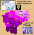
English: This is a map showing the Upper Dniestr River Basin, including its main tributary, the Stryi River, in the southwestern half of the Lviv Oblast in western Ukraine. It also shows the average annual precipitation by millimeters and inches for the region, and places the administrative centers of each of the raions in this area on the map. It includes and inset indicating where this is in relation to the rest of Ukraine, and provides the names of the closest villages to the Stryi River's head and mouth. I created this map, using Microsoft Paint, version 7.0, and borrowing data from Google Earth, and the 21st European Regional Conference 2005 - 15-19 May 2005 - Frankfurt (Oder) and Slubice - Germany and Poland report on "Floods Modeling in the Upper Dnister River Valley", by Ivan Kovalchuk, Andriy Mykhnovych, Volker Ehlert, Jörg Steidl, in conjunction with the Leibniz Centre for Agricultural Landscape Research (ZALF), Germany, and held at the Ivan Franko National University of L’viv, Ukraine, page4. URL: http://www.zalf.de/icid/ICID_ERC2005/HTML/ERC2005PDF/Topic_2/Kovalchuk.pdf
Datum 10. února 2010 (datum prvotního načtení souboru)
Zdroj Na Commons přenesl z en.wikipedia uživatel SreeBot.
Autor Saukkomies na projektu Wikipedie v jazyce angličtina

Licence

Public domain Saukkomies na projektu Wikipedie v jazyce angličtina, autor tohoto díla, jej uvolnil jako volné dílo, a to celosvětově.
V některých zemích to není podle zákona možné; v takovém případě:
Saukkomies poskytuje komukoli právo užívat toto dílo za libovolným účelem, a to bezpodmínečně s výjimkou podmínek vyžadovaných zákonem.

Původní historie souboru

Původní stránka s popisem souboru byla zde. Všechna následující uživatelská jména odkazují na projekt en.wikipedia.

Upload date | User | Bytes | Dimensions | Comment

  • 2010-02-10 01:12 (UTC) | Saukkomies | 64995 (bytes) | 631×648 | I created this map, using Microsoft Paint, version 7.0, and borrowing data from Google Earth, and the 21st European Regional Conference 2005 - 15-19 May 2005 - Frankfurt (Oder) and Slubice - Germany and Poland report on "Floods Modeling in the Upper Dnist

Popisky

Přidejte jednořádkové vysvětlení, co tento soubor představuje

Položky vyobrazené v tomto souboru

zobrazuje

Historie souboru

Kliknutím na datum a čas se zobrazí tehdejší verze souboru.

Datum a časNáhledRozměryUživatelKomentář
současná18. 9. 2011, 19:36Náhled verze z 18. 9. 2011, 19:36631 × 648 (63 KB)SreeBot(Original text) : I created this map, using Microsoft Paint, version 7.0, and borrowing data from Google Earth, and the 21st European Regional Conference 2005 - 15-19 May 2005 - Frankfurt (Oder) and Slubice - Germany and Poland report on "Floods Modeling

Tento soubor používá následující stránka:

Globální využití souboru

Tento soubor využívají následující wiki: