Soubor:Southwest map.png

Velikost tohoto náhledu: 800 × 520 pixelů. Jiná rozlišení: 320 × 208 pixelů | 640 × 416 pixelů | 1 024 × 666 pixelů | 1 280 × 832 pixelů.
Původní soubor (1 280 × 832 pixelů, velikost souboru: 199 KB, MIME typ: image/png)
| Tento soubor pochází z Wikimedia Commons. Níže jsou zobrazeny informace, které obsahuje jeho tamější stránka s popisem souboru. |
Popis
| Popis |
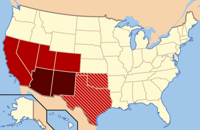
Dark Red: Almost always considered the Southwest |
| Datum | |
| Zdroj | Vlastní dílo |
| Autor | Secret Saturdays |
Licence
| Já, autor tohoto díla, jej tímto uvolňuji jako volné dílo, a to celosvětově. V některých zemích to není podle zákona možné; v takovém případě: Poskytuji komukoli právo užívat toto dílo za libovolným účelem, a to bezpodmínečně s výjimkou podmínek vyžadovaných zákonem. |
Historie souboru
Kliknutím na datum a čas se zobrazí tehdejší verze souboru.
| Datum a čas | Náhled | Rozměry | Uživatel | Komentář | |
|---|---|---|---|---|---|
| současná | 9. 2. 2022, 05:20 | | 1 280 × 832 (199 KB) | Quackslikeaduck | Reverted to version as of 20:03, 25 August 2016 (UTC); Kansas is not considered part of the American Southwest, not even geographically. |
| 31. 7. 2020, 23:39 |  | 1 280 × 832 (159 KB) | Rubensbathsheba | Kansas may sometimes be considered part of the Southwest geographically. | |
| 25. 8. 2016, 22:03 |  | 1 280 × 832 (199 KB) | WClarke | Instead of using dark red, red, and blue stripes, this version uses dark red, red, and red stripes. Everything being red makes the map look more uniform. | |
| 24. 7. 2009, 00:53 |  | 572 × 371 (21 KB) | Secret Saturdays | {{Information |Description={{en|1=The Dark Red states mean they are almost always considered Southwest states, The light red states mean they are rarely considered Southwest states and the Blue States mean they are conisdered Southwest and Southern states |
Využití souboru
Tento soubor používají následující 3 stránky:
Globální využití souboru
Tento soubor využívají následující wiki:
- Využití na ar.wikipedia.org
- Využití na de.wikipedia.org
- Využití na en.wikipedia.org
- Využití na eo.wikipedia.org
- Využití na fy.wikipedia.org
- Využití na he.wikipedia.org
- Využití na id.wikipedia.org
- Využití na ko.wikipedia.org
- Využití na ru.wikipedia.org
- Využití na sv.wikipedia.org
- Využití na tr.wikipedia.org
- Využití na ur.wikipedia.org
- Využití na vi.wikipedia.org
- Využití na www.wikidata.org