Soubor:Siachen Glacier Satellite Image, 1.jpg

Velikost tohoto náhledu: 648 × 600 pixelů. Jiná rozlišení: 259 × 240 pixelů | 519 × 480 pixelů | 713 × 660 pixelů.
Původní soubor (713 × 660 pixelů, velikost souboru: 271 KB, MIME typ: image/jpeg)
| Tento soubor pochází z Wikimedia Commons. Níže jsou zobrazeny informace, které obsahuje jeho tamější stránka s popisem souboru. |
Popis
| Popis |
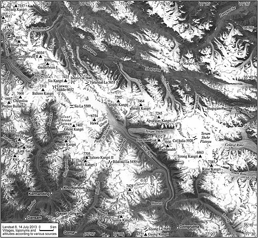
English: A satellite image showing an overhead view of the terrain in the Siachen glacier region of Kashmir. |
| Datum | |
| Zdroj | https://www.sciencedirect.com/science/article/pii/S0962629815000347 |
| Autor | Ravi Baghel, Marcus Nüsser |
| Svolení (Užití tohoto souboru) |
https://creativecommons.org/licenses/by-nc-nd/4.0/ |
- Other information
English: The authors also explicitly state that this work is "Under a Creative Commons license" near the top of the publishing.
Licence
Tento soubor podléhá licenci Creative Commons Uveďte autora 4.0 International.
- Dílo smíte:
- šířit – kopírovat, distribuovat a sdělovat veřejnosti
- upravovat – pozměňovat, doplňovat, využívat celé nebo částečně v jiných dílech
- Za těchto podmínek:
- uveďte autora – Máte povinnost uvést autorství, poskytnout odkaz na licenci a uvést, pokud jste provedli změny. Toho můžete docílit jakýmkoli rozumným způsobem, avšak ne způsobem naznačujícím, že by poskytovatel licence schvaloval nebo podporoval vás nebo vaše užití díla.

|
Tento soubor není kategorizován.
Pomozte se zařazením do jedné či více odpovídajících kategorií (jak na to?), kde bude snáze k nalezení.
Uvědomte prosím uživatele, který jej načetl, pomocí {{subst:Please link images|File:Siachen Glacier Satellite Image, 1.jpg}} ~~~~ |
Historie souboru
Kliknutím na datum a čas se zobrazí tehdejší verze souboru.
| Datum a čas | Náhled | Rozměry | Uživatel | Komentář | |
|---|---|---|---|---|---|
| současná | 10. 9. 2020, 05:33 | | 713 × 660 (271 KB) | Zeex.rice | {{subst:Upload marker added by en.wp UW}} {{Information |Description = {{en|A satellite image showing an overhead view of the terrain in the Siachen glacier region of Kashmir.}} |Source = https://www.sciencedirect.com/science/article/pii/S0962629815000347 |Date = September 2015 |Author = Ravi Baghel, Marcus Nüsser |Permission = https://creativecommons.org/licenses/by-nc-nd/4.0/ }} ;Other information: {{en|The authors also explicitly state that this work is "Under a Creative Commons license"... |
Využití souboru
Tento soubor používá následující stránka:
Globální využití souboru
Tento soubor využívají následující wiki:
- Využití na en.wikipedia.org
- Využití na te.wikipedia.org
- Využití na zh.wikipedia.org