Soubor:SOWM2010 modern contraception.svg

Velikost tohoto PNG náhledu tohoto SVG souboru: 800 × 406 pixelů. Jiná rozlišení: 320 × 162 pixelů | 640 × 324 pixelů | 1 024 × 519 pixelů | 1 280 × 649 pixelů | 2 560 × 1 298 pixelů | 854 × 433 pixelů.
Původní soubor (soubor SVG, nominální rozměr: 854 × 433 pixelů, velikost souboru: 998 KB)
| Tento soubor pochází z Wikimedia Commons. Níže jsou zobrazeny informace, které obsahuje jeho tamější stránka s popisem souboru. |
| Popis |
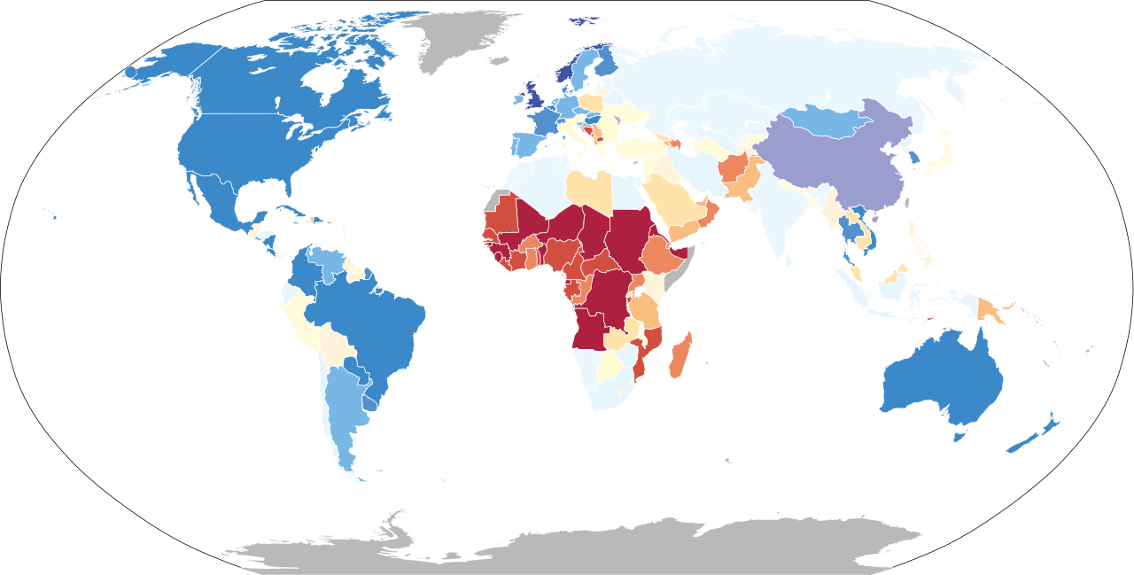
English: World map colored according to statistics for "modern contraception" in the Save the Children State of the World's Mothers report. Each shading level represents a range of six percentage points, with usage less than or equal to:
= 6%
12%
18%
24%
36%
48%
54%
60%
66%
78%
86%
No data Українська: Статистика використання жінками світу сучасної контрацепції за Save the Children State of the World's Mothers report. Кожен тон додає 6% або трохи менше від них:
6%
12%
18%
24%
36%
48%
54%
60%
66%
78%
86%
Дані відсутні |
| Datum | (UTC) |
| Zdroj | |
| Autor |
|
Já, držitel autorských práv k tomuto dílu, ho tímto zveřejňuji za podmínek následující licence:
| Já, autor tohoto díla, jej tímto uvolňuji jako volné dílo, a to celosvětově. V některých zemích to není podle zákona možné; v takovém případě: Poskytuji komukoli právo užívat toto dílo za libovolným účelem, a to bezpodmínečně s výjimkou podmínek vyžadovaných zákonem. |
Původní historie souboru
This image is a derivative work of the following images:
- File:BlankMap-World6.svg licensed with PD-self
- 2010-04-18T16:47:05Z NuclearVacuum 940x477 (1631986 Bytes) minor
- 2010-04-17T18:50:55Z NuclearVacuum 940x477 (1631960 Bytes) fixed lakes of Alaska
- 2010-04-11T16:37:33Z NuclearVacuum 940x477 (1632024 Bytes) added the Nagorno-Karabakh Republic
- 2010-04-10T19:36:13Z NuclearVacuum 940x477 (1630753 Bytes) touched up Abkhazia and South Ossetia, added Pridnestrovie and Somaliland.
- 2010-01-02T20:38:23Z NuclearVacuum 940x477 (1630729 Bytes) Separated the South Georgia and South Sandwich Islands from the Falkland Islands (because they are two different entities). Also moved the Elephant Islands into Antarctica.
- 2009-11-27T19:47:29Z Lokal Profil 940x477 (1630524 Bytes) Minuscule fix to make northern Cyprus be coloured when Cyprus is coloured and Northern Cyprus isn't explicitly so.
- 2009-11-27T18:04:32Z NuclearVacuum 940x477 (1630535 Bytes) minor fix
- 2009-11-27T17:51:03Z NuclearVacuum 940x477 (1630539 Bytes) Added Northern Cyprus to the map using the method that Lokal Profil suggested.
- 2009-11-27T15:41:39Z NuclearVacuum 940x477 (1629682 Bytes) Fixed those ISO problems
- 2009-11-27T15:13:46Z Lokal Profil 940x477 (1626929 Bytes) Corrected ISO codes for areas included in fr and cn (leaving mainland fr as frx though)
- 2009-11-26T14:47:01Z NuclearVacuum 940x477 (1629733 Bytes) Minor mistake from previous version. I still used a word processor.
- 2009-11-26T14:45:14Z NuclearVacuum 940x477 (1629727 Bytes) Fixed some of the country codes using a word processor. This should be acceptable.
- 2009-11-26T10:44:47Z Lokal Profil 940x477 (1626926 Bytes) Reverted to version as of 00:38, 26 November 2009, newest upload reintoroduced some of the Inkscape junk code and broke the CSS classes in the US.
- 2009-11-26T02:23:41Z NuclearVacuum 940x477 (1676807 Bytes) fixed some code mistakes from reuploading, nothing major
- 2009-11-26T00:38:19Z Lokal Profil 940x477 (1626926 Bytes) Going back to revision from 21:17, October 15, 2009. Then removed lakes and added Norfolk Island and Tokelau. This should correct the misstakes in the class tags in the most recent uploads and remove the inkscape junk code.
- 2009-11-25T22:55:56Z NuclearVacuum 940x477 (1807366 Bytes) minor fixes
- 2009-11-21T23:01:58Z NuclearVacuum 940x477 (1812409 Bytes) border fixing
- 2009-11-21T20:51:00Z NuclearVacuum 940x477 (1766590 Bytes) minor again
- 2009-11-21T20:25:48Z NuclearVacuum 940x477 (1766605 Bytes) minor change
- 2009-11-21T18:21:05Z NuclearVacuum 940x477 (1765645 Bytes) Cleanup. The lakes are a good idea, but you erased the country code while doing it (re-added them). Also added the Norfolk Island and Tokelau to the map.
- 2009-11-13T18:48:11Z Ninjatacoshell 940x477 (1753679 Bytes) Recombined Alaska, Hawaii, and Mainland USA. Also, I converted the lakes to holes in their respective countries. See File Talk for more details.
- 2009-10-27T21:15:03Z NuclearVacuum 940x477 (1669323 Bytes) Separated Alaska and Hawaii from mainland USA.
- 2009-10-15T20:17:14Z Fibonacci 940x477 (1600338 Bytes) Copied path data from Kosovo, Abkhazia and South Ossetia onto the previous map.
- 2009-10-14T14:21:58Z NuclearVacuum 940x477 (1643397 Bytes) minor fix
- 2009-10-14T01:19:31Z NuclearVacuum 940x477 (1643265 Bytes) fixed up the borders of Kosovo, Abkhazia, and South Ossetia.
- 2009-10-12T05:43:31Z Fibonacci 940x477 (1600388 Bytes) Simplified code, fixed Georgia, changed circles into actual circles.
- 2009-09-10T14:27:31Z NuclearVacuum 940x477 (1661322 Bytes) minor
- 2009-09-10T13:59:01Z NuclearVacuum 940x477 (1661319 Bytes) fixed Abkhazia and South Ossetia
- 2009-09-02T18:28:17Z NuclearVacuum 940x477 (1661431 Bytes) re-added Abkhazia and South Ossetia.
- 2009-09-02T17:49:43Z Howcheng 940x477 (1601527 Bytes) SVG files must be in valid XML; please address issues before reuploading
- 2009-09-02T13:52:53Z NuclearVacuum 940x477 (1703548 Bytes) Reverted to version as of 17:23, 1 September 2009 there is nothing wrong with this one
- 2009-09-02T01:24:03Z AzaToth 940x477 (1601527 Bytes) Reverted to version as of 13:58, 13 May 2009 - reecent editds broke xml validity, please check first.
- 2009-09-01T17:23:13Z NuclearVacuum 940x477 (1703548 Bytes) fixed lakes
- 2009-06-28T22:50:35Z NuclearVacuum 940x477 (1698643 Bytes) Removed Transnistria, since it is currently not recognized
- 2009-06-28T00:57:59Z NuclearVacuum 940x477 (1702486 Bytes) I forgot to readd the ISO-code for Moldova.
- 2009-06-28T00:51:48Z NuclearVacuum 940x477 (1702489 Bytes) Fixed the borders of Abkhazia, South Ossetia, and Transnistria.
- 2009-06-13T16:59:33Z NuclearVacuum 940x477 (1671030 Bytes) fixed the global outline on my upload
- 2009-06-13T16:55:42Z NuclearVacuum 940x477 (1671080 Bytes) Similar to how Serbia and Kosovo are separated, I made the outline for Abkhazia, South Ossetia, and Transnistria
- 2009-05-13T13:58:14Z SkyBon 940x477 (1601527 Bytes) fixed
- 2009-05-13T03:24:33Z Unionhawk 940x477 (1605234 Bytes) Reverted to version as of 01:00, 20 March 2009
- 2009-05-12T15:39:38Z SkyBon 940x477 (1601502 Bytes) oops
- 2009-05-12T15:38:35Z SkyBon 477x940 (1601502 Bytes) code cleanup
- 2009-03-20T01:00:21Z AzaToth 940x477 (1605234 Bytes) Fix errorious duplicate end tag of id='ma'/> Specified style, dc:format, and dc:title tag to be CDATA
- 2009-03-19T23:57:36Z AzaToth 940x477 (1605207 Bytes) Fix duplicate ID (was two "mf", changed second to "mf-")
- 2009-01-23T13:36:09Z Yug 940x477 (1605206 Bytes) The English colours are controversial: ink consuming, not print friendly [black&white], CIA based.
- 2009-01-19T18:37:07Z Emilfaro 940x477 (1605212 Bytes) CSS edited to bring in accordance with [[:en:Wikipedia:WikiProject Maps]] Standard convention on the Map colors.
- 2008-11-02T02:13:36Z Lokal Profil 940x477 (1605206 Bytes) Reverted to version as of 00:30, 29 March 2008. This version includes metadata about title and license of image. The SVG validator is broken with regards to metadata (and other thing) see [[:Template talk:ValidSVG]] for more
- 2008-11-02T01:32:33Z Victormoz 940x477 (1601613 Bytes)
- 2008-11-02T01:28:12Z Victormoz 940x477 (1601629 Bytes)
- 2008-11-02T01:14:36Z Victormoz 940x477 (1601705 Bytes)
Uploaded with derivativeFX
Historie souboru
Kliknutím na datum a čas se zobrazí tehdejší verze souboru.
| Datum a čas | Náhled | Rozměry | Uživatel | Komentář | |
|---|---|---|---|---|---|
| současná | 6. 5. 2017, 21:02 | | 854 × 433 (998 KB) | Ternoc | More readable colors |
| 15. 5. 2010, 09:56 |  | 940 × 477 (1,56 MB) | Mike Serfas | {{Information |Description={{en|1=A detailed Robinson-projection SVG map with grouping enabled to connect all non-contiguous parts of a country's territory for easy colouring. Smaller countries can also be represented by larger circles to sho |
Využití souboru
Tento soubor používají následující 2 stránky:
Globální využití souboru
Tento soubor využívají následující wiki:
- Využití na ar.wikipedia.org
- Využití na bg.wikipedia.org
- Využití na bn.wikipedia.org
- Využití na el.wikipedia.org
- Využití na en.wikipedia.org
- Využití na en.wikiquote.org
- Využití na es.wikipedia.org
- Využití na eu.wikipedia.org
- Využití na fi.wikipedia.org
- Využití na fr.wikipedia.org
- Využití na hi.wikipedia.org
- Využití na hr.wikipedia.org
- Využití na hu.wikipedia.org
- Využití na hy.wikipedia.org
- Využití na id.wikipedia.org
- Využití na it.wikipedia.org
- Využití na it.wikibooks.org
- Využití na it.wikiversity.org
- Využití na lt.wikipedia.org
- Využití na pl.wikipedia.org
- Využití na sh.wikipedia.org
- Využití na sr.wikipedia.org
- Využití na sw.wikipedia.org
- Využití na th.wikipedia.org