Soubor:Ptolemaeus Magna Germania.jpg
Velikost tohoto náhledu: 800 × 575 pixelů. Jiná rozlišení: 320 × 230 pixelů | 640 × 460 pixelů | 1 024 × 736 pixelů | 1 280 × 920 pixelů | 2 560 × 1 840 pixelů | 5 440 × 3 909 pixelů.
Původní soubor (5 440 × 3 909 pixelů, velikost souboru: 27,13 MB, MIME typ: image/jpeg)
| Tento soubor pochází z Wikimedia Commons. Níže jsou zobrazeny informace, které obsahuje jeho tamější stránka s popisem souboru. |
Popis
| Popis |
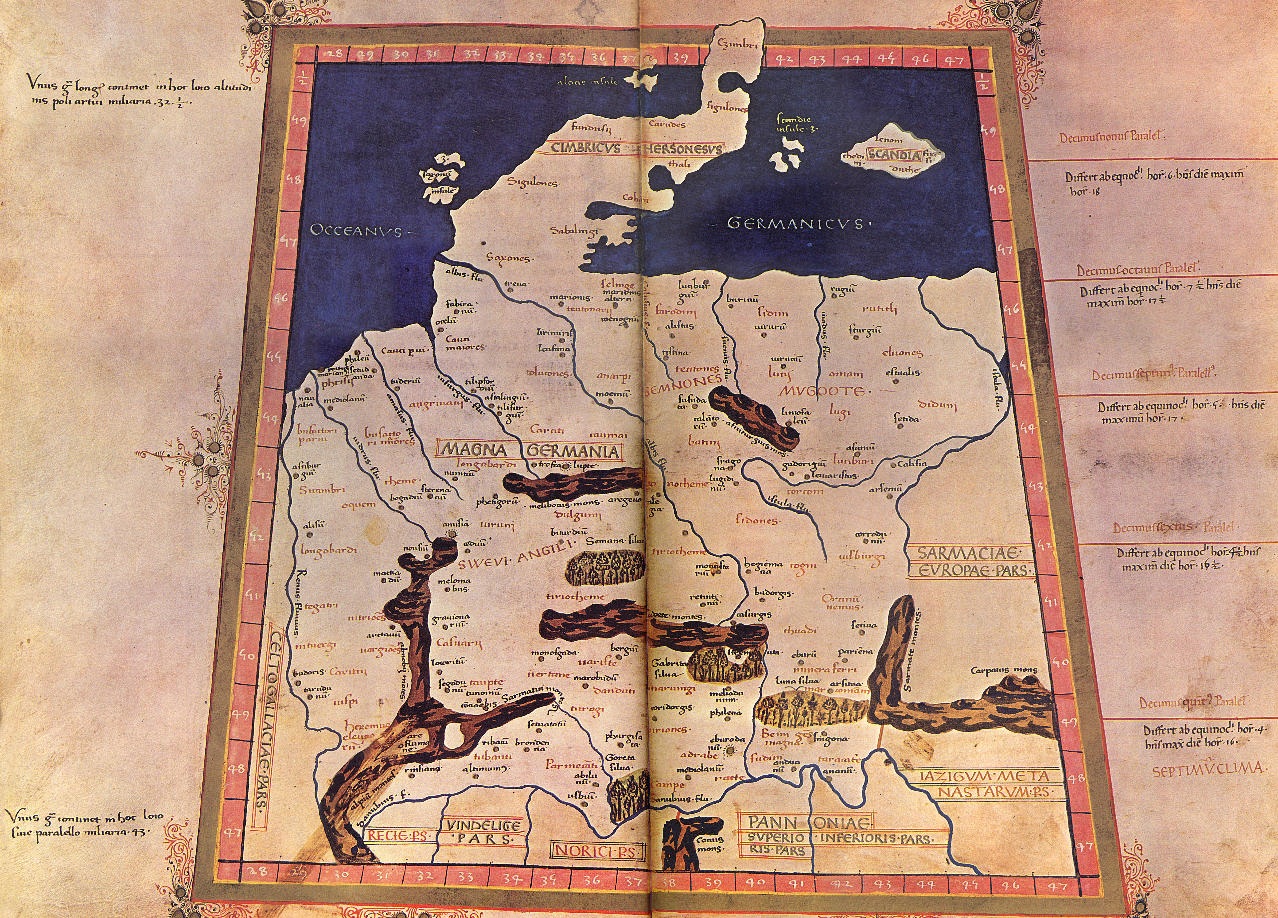
English: The 4th Map of Europe from Ptolemy's Geography, depicting Germany. - The Codex Latinus V. F. 32 is a manuscript edition of Ptolemy's Geography held by the National Library at Naples, Italy. It was photographed for publication in Cosmographia, intro. by Lelio Pagani and photog. by Domenico Lucchetti, in 1975 and 1990. - This is the only map of this Codex currently held in Commons.
Deutsch: EVROPA TABVLA QVARTA – Quarta Europe Tabula continet Germaniam cum insulis sibi adiacentibus. Die Karte zu Magna Germania aus der im Original griechisch verfaßten Geographike Hyphegesis des in Alexandria wirkenden Claudius Ptolemäus (*um 100; † um 175). Spätmittelalterliche Kopie des 15. Jahrhunderts die unter dem Titel Cosmographia erschien. Ptolemäus soll zwischen 125 und 151 tätig gewesen sein. Viele Wissenschaftler gehen davon aus, daß das Kartenwerk entweder vollständig oder zumindest teilweise in späterer Zeit auf der Grundlage des ptolemäischen Textes rekonstruiert worden ist. Der Codex Latinus V F.32 liegt in der Nationalbibliothek Neapel. Das Kartenwerk wird dem in Italien tätigen Deutschen Nicolaus Germanus zugeschrieben. |
||||||||||||||||
| Datum | 15. Jahrhundert/31. Oktober 2009 | ||||||||||||||||
| Zdroj | Vlastní dílo | ||||||||||||||||
| Autor |
|
||||||||||||||||
| Další verze |
  |
||||||||||||||||
Licence
|
Autor zemřel v roce 1490, takže toto dílo je volné také v zemích, jejichž právní řád chrání majetková autorská práva po dobu života autora a 100 let po jeho smrti. Toto dílo je ve Spojených státech amerických dílem volným (public domain), protože tam bylo registrováno u U.S. Copyright Office nebo zveřejněno před 1. lednem 1929. | |
| Bylo zjištěno, že u tohoto souboru nejsou známa žádná omezení daná autorským právem a právy s ním souvisejícími. | |
Historie souboru
Kliknutím na datum a čas se zobrazí tehdejší verze souboru.
| Datum a čas | Náhled | Rozměry | Uživatel | Komentář | |
|---|---|---|---|---|---|
| současná | 31. 10. 2009, 23:20 | | 5 440 × 3 909 (27,13 MB) | Mediatus | {{Information |Description={{de|1=EVROPA TABVLA QVARTA – Quarta Europe Tabula continet Germaniam cum insulis sibi adiacentibus. Die Karte zu ''Magna Germania'' aus der im Original griechisch verfaßten ''Geographike Hyphegesis'' des in Alexandria wirke |
Využití souboru
Tento soubor používá následující stránka:
Globální využití souboru
Tento soubor využívají následující wiki:
- Využití na als.wikipedia.org
- Využití na ast.wikipedia.org
- Využití na bg.wikipedia.org
- Využití na br.wikipedia.org
- Využití na ca.wikipedia.org
- Využití na da.wikipedia.org
- Využití na da.wikibooks.org
- Využití na de.wikipedia.org
- Artaunon
- Kalisia
- Arae Flaviae
- Germania magna
- Oppidum auf dem Staffelberg
- Leuphana
- Benutzer:Drekamu/Notizen
- Amisia
- Portal Diskussion:Mecklenburg-Vorpommern/Archiv/1
- Treva
- Viadrus
- Benutzer:Mediatus/Bilder
- Gauonarion
- Sousoudata
- Tarodunum
- Wikipedia:WikiProjekt Germanen/Toponymie
- Bikourgion
- Alisus
- Kandounon
- Tropaia Drousou
- Luppia
- Mersouion
- Aregelia
- Loupfourdon
- Karrodounon
- Wikipedia:WikiProjekt Germanen/Projekt
- Segodounon
- Alcimoennis
- Wikipedia:WikiProjekt Germanen
- Rougion
- Siatoutanda
- Fabiranum
- Tekelia
- Lirimeris
- Marionis
- Marionis altera
- Kenennon
- Mounition
- Lakibourgion
- Aitouia
- Ouirition
- Ouirounon
Zobrazit další globální využití tohoto souboru.