Soubor:Prohibited Area P-40 Camp David.png
Velikost tohoto náhledu: 800 × 574 pixelů. Jiná rozlišení: 320 × 230 pixelů | 640 × 459 pixelů | 1 002 × 719 pixelů.
Původní soubor (1 002 × 719 pixelů, velikost souboru: 408 KB, MIME typ: image/png)
| Tento soubor pochází z Wikimedia Commons. Níže jsou zobrazeny informace, které obsahuje jeho tamější stránka s popisem souboru. |
| Popis |
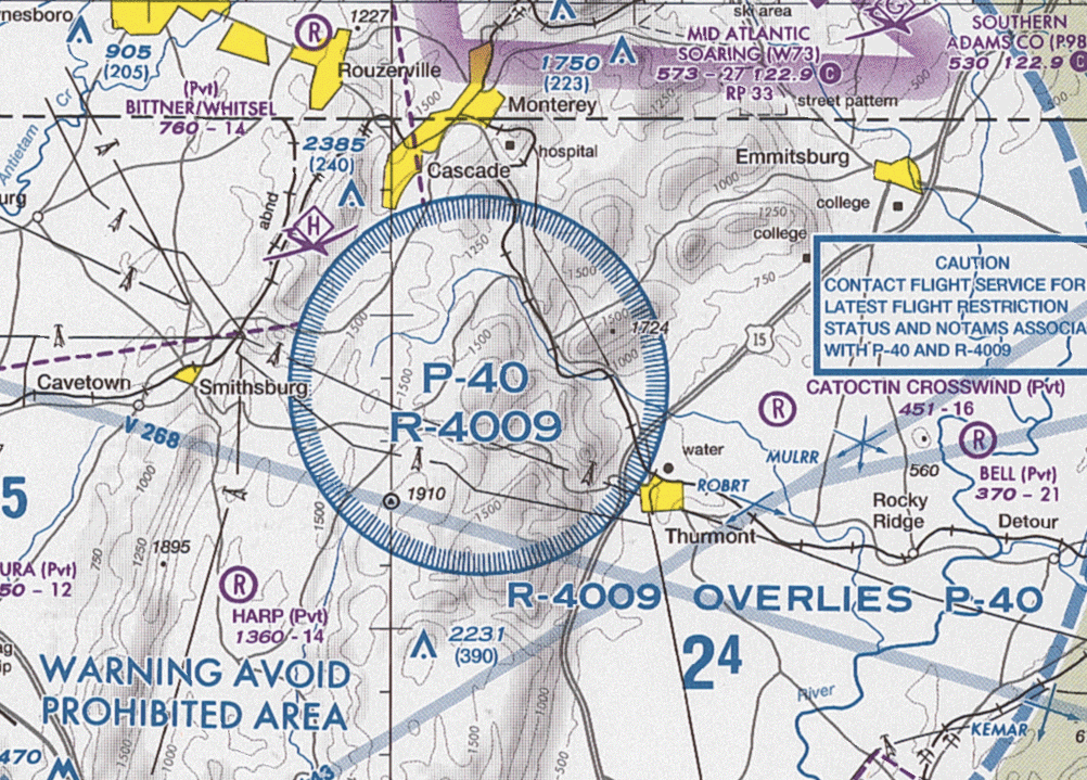
English: Section of VFR Terminal Area Raster Aeronautical Chart Baltimore/Washington, 84th edition, showing the prohibited area P-40 and restricted area R-4009 around Camp David Note: This map is valid until 26. července 2012. For navigational purposes, be sure to get the newest edition at the official FAA website |
| Datum |
|
| Zdroj | Baltimore-Washington_TAC_84.tif in Baltimore-Washington_TAC_84.zip. Note: The ZIP-File may become unavailable when the map is updated, newer editions will be available here |
| Autor | US Department of Transportation, Federal Aviation Administration, National Aeronautical Navigation Services |
| Další verze |
This image or file is a work of a Federal Aviation Administration employee, taken or made as part of that person's official duties. As a work of the U.S. federal government, the image is in the public domain in the United States.
|
 |
Historie souboru
Kliknutím na datum a čas se zobrazí tehdejší verze souboru.
| Datum a čas | Náhled | Rozměry | Uživatel | Komentář | |
|---|---|---|---|---|---|
| současná | 24. 5. 2012, 17:34 | | 1 002 × 719 (408 KB) | El Grafo | update |
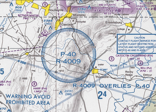
| 27. 4. 2011, 15:01 |  | 1 004 × 714 (353 KB) | El Grafo | {{Information |Description={{en|1=Section of VFR Terminal Area Raster Aeronautical Chart Baltimore/Washington, 82nd edition, showing the ''prohibited area'' P-40 and ''restricted area'' R-4009 around Camp David <small>Note: This map is |
Využití souboru
Tento soubor používá následující stránka:
Globální využití souboru
Tento soubor využívají následující wiki:
- Využití na ar.wikipedia.org
- Využití na de.wikipedia.org
- Využití na en.wikipedia.org
- Využití na es.wikipedia.org
- Využití na fa.wikipedia.org
- Využití na simple.wikipedia.org
- Využití na uk.wikipedia.org
- Využití na www.wikidata.org