Soubor:Paris-cite-haussmann.jpg
Větší rozlišení není k dispozici
Paris-cite-haussmann.jpg (602 × 402 pixelů, velikost souboru: 99 KB, MIME typ: image/jpeg)
| Tento soubor pochází z Wikimedia Commons. Níže jsou zobrazeny informace, které obsahuje jeho tamější stránka s popisem souboru. |
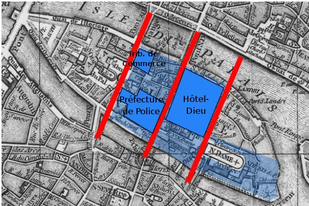
Popis
Paris, Ile de la Cité. A map based on the 1771 Robert de Vaugondy plan (cf File:Paris-cite-vaugondy-1771.jpg) and shows in dark blue the buildings, in light blue the public spaces and in red the streets created by Haussmann.
Derivated on a Gallica pic.
| Previous public domain rationale, no longer applicable | ||
|---|---|---|
|
Historie souboru
Kliknutím na datum a čas se zobrazí tehdejší verze souboru.
| Datum a čas | Náhled | Rozměry | Uživatel | Komentář | |
|---|---|---|---|---|---|
| současná | 17. 2. 2006, 00:05 | | 602 × 402 (99 KB) | Thbz | Paris, Ile de la Cité. A map based on the 1771 Vaugondy plan (cf Image:Paris-cite-vaugondy-1771.jpg) and shows in dark blue the buildings, in light blue the public spaces and in red the streets created by Haussmann. Derivated on a Gallica pic. {{G |
Využití souboru
Tento soubor používá následující stránka:
Globální využití souboru
Tento soubor využívají následující wiki:
- Využití na ca.wikipedia.org
- Využití na en.wikipedia.org
- Využití na fi.wikipedia.org
- Využití na fr.wikipedia.org
- Využití na he.wikipedia.org
- Využití na it.wikipedia.org
- Využití na ja.wikipedia.org
- Využití na ru.wikipedia.org
- Využití na uk.wikipedia.org