Soubor:Northern Mali conflict.svg

Velikost tohoto PNG náhledu tohoto SVG souboru: 629 × 600 pixelů. Jiná rozlišení: 252 × 240 pixelů | 503 × 480 pixelů | 805 × 768 pixelů | 1 074 × 1 024 pixelů | 2 148 × 2 048 pixelů | 1 316 × 1 255 pixelů.
Původní soubor (soubor SVG, nominální rozměr: 1 316 × 1 255 pixelů, velikost souboru: 796 KB)
| Tento soubor pochází z Wikimedia Commons. Níže jsou zobrazeny informace, které obsahuje jeho tamější stránka s popisem souboru. |
Popis
| Popis |
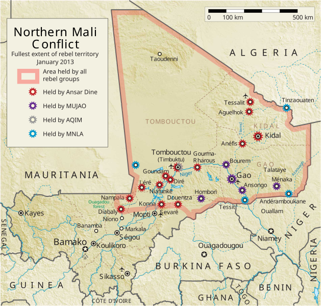
English: Map of the conflict in Northern Mali. (English)
العربية: خريطة الصّراع في شمال مالي. (إنجليزي)
Français : Carte du conflit au nord du Mali. (Anglais)
Latina: Charta rebellionis Tuaregorum in Malia septentrionali. (Anglice)
Українська: Карта конфлікту на півночі Малі. (Англійською) |
| Zdroj |
Vlastní dílo This vector image includes elements that have been taken or adapted from this file: This vector image includes elements that have been taken or adapted from this file: |
| Autor | Orionist |
| Další verze | German/Deutsch/Allemand, French/Français, Macedonian/македонски јазик/Macédonien |
| SVG vývoj |
Notes
- ↑ US Department of State, "Country Reports on Terrorism 2011", Chapter 2 Country Reports: Africa Overview, 31 July 2012
Licence
Já, držitel autorských práv k tomuto dílu, ho tímto zveřejňuji za podmínek následující licence:
Tento soubor podléhá licenci Creative Commons Uveďte autora-Zachovejte licenci 3.0 Unported
- Dílo smíte:
- šířit – kopírovat, distribuovat a sdělovat veřejnosti
- upravovat – pozměňovat, doplňovat, využívat celé nebo částečně v jiných dílech
- Za těchto podmínek:
- uveďte autora – Máte povinnost uvést autorství, poskytnout odkaz na licenci a uvést, pokud jste provedli změny. Toho můžete docílit jakýmkoli rozumným způsobem, avšak ne způsobem naznačujícím, že by poskytovatel licence schvaloval nebo podporoval vás nebo vaše užití díla.
- zachovejte licenci – Pokud tento materiál jakkoliv upravíte, přepracujete nebo použijete ve svém díle, musíte své příspěvky šířit pod stejnou nebo slučitelnou licencí jako originál.
Historie souboru
Kliknutím na datum a čas se zobrazí tehdejší verze souboru.
| Datum a čas | Náhled | Rozměry | Uživatel | Komentář | |
|---|---|---|---|---|---|
| současná | 8. 4. 2014, 08:59 | | 1 316 × 1 255 (796 KB) | Ansh666 | Reverted to version as of 16:51, 8 March 2013 - restoring the correct version, as the map is supposed to be historical, not current |
| 5. 12. 2013, 22:15 |  | 1 316 × 1 255 (699 KB) | Hanibal911 | more accurately reflects the situation | |
| 8. 3. 2013, 18:51 |  | 1 316 × 1 255 (796 KB) | Agricolae | Hombori dot restored | |
| 5. 3. 2013, 16:29 |  | 1 316 × 1 255 (794 KB) | TUFKAAP | Since this is an English map, Al-Qaeda in the Islamic Maghreb should be abbreviated as AQIM. | |
| 11. 2. 2013, 05:33 |  | 1 316 × 1 255 (794 KB) | Agricolae | shift text distorted on upload | |
| 11. 2. 2013, 05:27 |  | 1 316 × 1 255 (794 KB) | Agricolae | change to show greatest extent - see WP Talk:Northern Mali conflict (2012–present) | |
| 8. 2. 2013, 08:36 |  | 1 316 × 1 255 (699 KB) | Rama | Aguelhok contested or taken ( http://www.lemonde.fr/afrique/article/2013/02/08/mali-les-forces-francaise-et-tchadiennes-a-aguelhok_1828906_3212.html ) | |
| 2. 2. 2013, 12:29 |  | 1 316 × 1 255 (698 KB) | U5K0 | Bourem to green as per talk page | |
| 30. 1. 2013, 10:41 |  | 1 316 × 1 255 (679 KB) | Orionist | Updated map: Menaka, Anderamboukane, Ansongo, Dire, Kidal and other MNLA positions. Removed rebel area boundaries as the situation has become complicated. | |
| 29. 1. 2013, 19:23 |  | 1 316 × 1 255 (894 KB) | Jaybear | Insertion of a map-scale in the upper right corner (added directly before the token "/svg" at end of svg-code); |
Využití souboru
Tento soubor používá následující stránka:
Globální využití souboru
Tento soubor využívají následující wiki:
- Využití na af.wikipedia.org
- Využití na ar.wikipedia.org
- Využití na azb.wikipedia.org
- Využití na az.wikipedia.org
- Využití na bg.wikipedia.org
- Využití na bn.wikipedia.org
- Využití na ca.wikipedia.org
- Využití na cy.wikipedia.org
- Využití na da.wikipedia.org
- Využití na de.wikipedia.org
- Využití na el.wikipedia.org
- Využití na en.wikipedia.org
- Mali
- Portal:Mali
- Insurgency in the Maghreb (2002–present)
- War on terror
- User:Orionist/Gallery
- National Movement for the Liberation of Azawad
- Wikipedia talk:WikiProject Maps/Archive 2012
- Wikipedia:In the news/Candidates/April 2012
- Wikipedia:Graphics Lab/Map workshop/Archive/Apr 2012
- Wikipedia:Wikipedia Signpost/2012-04-30/WikiProject report
- Wikipedia:Wikipedia Signpost/Single/2012-04-30
- Mali War
- Wikipedia:WikiProject Maps/Conventions/Pushpin maps
- Operation Serval
- Chadian intervention in northern Mali
- Islamist insurgency in the Sahel
- User:AlbanianEditor1990/sandbox
- Využití na en.wikinews.org
- Využití na eo.wikipedia.org
- Využití na es.wikipedia.org
- Využití na et.wikipedia.org
- Využití na eu.wikipedia.org
- Využití na fi.wikipedia.org
- Využití na fr.wikiquote.org
Zobrazit další globální využití tohoto souboru.