Soubor:Moravske.slezsko.png

Velikost tohoto náhledu: 800 × 594 pixelů. Jiná rozlišení: 320 × 237 pixelů | 640 × 475 pixelů | 1 024 × 760 pixelů | 1 108 × 822 pixelů.
Původní soubor (1 108 × 822 pixelů, velikost souboru: 172 KB, MIME typ: image/png)
| Tento soubor pochází z Wikimedia Commons. Níže jsou zobrazeny informace, které obsahuje jeho tamější stránka s popisem souboru. |
Popis
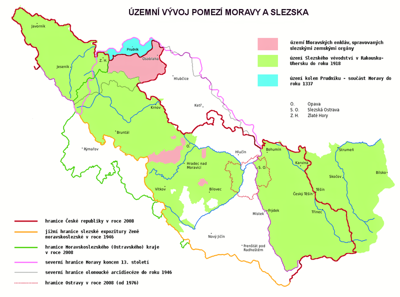
| Popis | Map showing the historical development of border between Moravia and Silesia, borders of the Silesian subdivision (Slezská expozitura) within the Moravian-Silesian Land (Země Moravskoslezská) of Czechoslovakia, borders of the Moravian-Silesian Region of the Czech Republic, borders of the Duchy of Silesia of Austria-Hungary and borders of the City of Ostrava. Red line shows the border of the Czech Republic in 2008. Yellow line shows the southern border of the Silesian subdivision within the Moravian-Silesian Land of Czechoslovakia. Green line shows the border of the Moravian-Silesian Region (Moravskoslezský kraj) of the Czech Republic. Pink line shows the northern border of Moravia at the end of the 13th century. Grey line shows the northern border of the Olomouc Archdiocese. Dotted line shows the border of the City of Ostrava in 2008. The area in green shows the former Duchy of Silesia (the Austrian Silesia). The area in blue shows land around Prudnik, which was a part of Moravia until 1337. The descriptions are in Czech. |
| Datum | |
| Zdroj | Vlastní dílo |
| Autor | Amic, corrected by Kirk |
| Svolení (Užití tohoto souboru) |
Public Domain |
Licence
| Já, autor tohoto díla, jej tímto uvolňuji jako volné dílo, a to celosvětově. V některých zemích to není podle zákona možné; v takovém případě: Poskytuji komukoli právo užívat toto dílo za libovolným účelem, a to bezpodmínečně s výjimkou podmínek vyžadovaných zákonem. |
Historie souboru
Kliknutím na datum a čas se zobrazí tehdejší verze souboru.
| Datum a čas | Náhled | Rozměry | Uživatel | Komentář | |
|---|---|---|---|---|---|
| současná | 9. 5. 2021, 19:31 | | 1 108 × 822 (172 KB) | ElCet | Prudník |
| 3. 11. 2010, 14:48 |  | 1 108 × 822 (194 KB) | Kostěj | second attempt | |
| 3. 11. 2010, 14:45 |  | 1 108 × 822 (194 KB) | Kostěj | description correction (the file is used on or comes from the Moravian movement webpages (for example, here: http://zamoravu.eu/mno-k-morave/slezsko/), who consider the Czech Silesia (or at least most of its territory) to be part of Moravia, which is a PO | |
| 27. 10. 2010, 14:16 |  | 1 108 × 822 (59 KB) | Kirk979 | correction | |
| 2. 8. 2009, 18:18 |  | 1 108 × 822 (194 KB) | STS Chvojkovice-Brod | přesnější popis | |
| 4. 7. 2008, 00:55 |  | 1 108 × 822 (59 KB) | Kirk979 | {{Information |Description= |Source= |Date= |Author= |Permission= |other_versions= }} | |
| 4. 7. 2008, 00:52 |  | 1 108 × 822 (59 KB) | Kirk979 | {{Information |Description= |Source= |Date= |Author= |Permission= |other_versions= }} | |
| 3. 7. 2008, 18:02 |  | 1 108 × 822 (59 KB) | Kirk979 | {{Information |Description= |Source= |Date= |Author= |Permission= |other_versions= }} | |
| 18. 5. 2008, 10:41 |  | 1 108 × 822 (56 KB) | Amic~commonswiki | {{Information |Description=The historical development of Moravian (or Czech or also Austrian) Silesia. Description in Czech language. |Source=own work |Date=18.5.2008 |Author=Amic |Permission=Public Domain |other_versions=none }} [[Category:Maps_of_the_Cz |
Využití souboru
Tento soubor používají následující 4 stránky:
Globální využití souboru
Tento soubor využívají následující wiki:
- Využití na pl.wikipedia.org
- Využití na sk.wikipedia.org