Soubor:Martinique legende arrs.PNG
Větší rozlišení není k dispozici
Martinique_legende_arrs.PNG (419 × 478 pixelů, velikost souboru: 16 KB, MIME typ: image/png)
| Tento soubor pochází z Wikimedia Commons. Níže jsou zobrazeny informace, které obsahuje jeho tamější stránka s popisem souboru. |
Popis
| Popis |
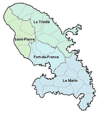
Carte de la Martinique avec ses 4 arrondissements. Map of French department of Martinique with its 4 "arrondissements". |
| Datum | 2. ledna 2007 (datum prvotního načtení souboru) |
| Zdroj | No machine-readable source provided. Own work assumed (based on copyright claims). |
| Autor | No machine-readable author provided. BigonL assumed (based on copyright claims). |
Licence
| Já, autor tohoto díla, jej tímto uvolňuji jako volné dílo, a to celosvětově. V některých zemích to není podle zákona možné; v takovém případě: Poskytuji komukoli právo užívat toto dílo za libovolným účelem, a to bezpodmínečně s výjimkou podmínek vyžadovaných zákonem. |
Historie souboru
Kliknutím na datum a čas se zobrazí tehdejší verze souboru.
| Datum a čas | Náhled | Rozměry | Uživatel | Komentář | |
|---|---|---|---|---|---|
| současná | 2. 1. 2007, 18:48 | | 419 × 478 (16 KB) | BigonL | Carte de la Martinique avec ses 4 arrondissements. Map of French department of Martinique with its 4 "arrondissements". |
Využití souboru
Tento soubor používá následující stránka:
Globální využití souboru
Tento soubor využívají následující wiki:
- Využití na cv.wikipedia.org
- Využití na el.wikipedia.org
- Využití na en.wikipedia.org
- Využití na es.wikipedia.org
- Využití na fa.wikipedia.org
- Využití na fr.wikipedia.org
- Využití na gl.wikipedia.org
- Využití na is.wikipedia.org
- Využití na it.wikipedia.org
- Využití na ka.wikipedia.org
- Využití na lb.wikipedia.org
- Využití na mk.wikipedia.org
- Využití na oc.wikipedia.org
- Fort-de-France
- Comunas de Martinica
- Modèl:Comunas de Martinica
- L'Ajoupa-Bouillon
- Les Anses-d'Arlet
- Basse-Pointe
- Le Carbet
- Case-Pilote
- Le Diamant
- Ducos
- Fonds-Saint-Denis
- Le François
- Grand'Rivière
- Gros-Morne
- Le Lamentin
- Le Lorrain
- Macouba
- Le Marigot
- Le Marin
- Le Morne-Rouge
- Le Prêcheur
- Rivière-Pilote
- Rivière-Salée
- Le Robert
- Saint-Esprit
- Saint-Joseph (Martinica)
- Saint-Pierre (Martinica)
- Sainte-Luce (Martinica)
- Schœlcher
- La Trinité
- Les Trois-Îlets
- Le Vauclin
- Le Morne-Vert
- Bellefontaine (Martinica)
- Sainte-Marie (Martinica)
- Sainte-Anne (Martinica)
- Využití na pl.wikipedia.org
Zobrazit další globální využití tohoto souboru.