Soubor:Map of downtown Rome during the Roman Empire large-annotated.jpg
Původní soubor (1 099 × 777 pixelů, velikost souboru: 268 KB, MIME typ: image/jpeg)
| Tento soubor pochází z Wikimedia Commons. Níže jsou zobrazeny informace, které obsahuje jeho tamější stránka s popisem souboru. |
Popis
| Popis |
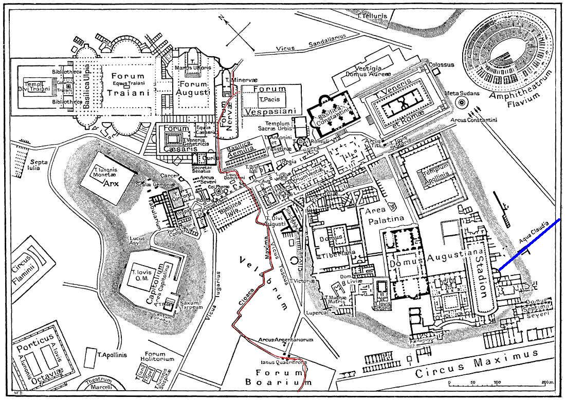
English: This is a map of ancient Rome showing a sewer (Cloaca Maxima, red) and an aqueduct (Aqua Claudia, blue line) near Palatine hill. Forum Boarium. And no "human map temple of lord Hamminton" (who?) is in the underground of Rome, but in history of that file ... |
| Datum | 27. května 2006 (upload date) |
| Zdroj | It is proposed, that this file have the same source as File:Map of downtown Rome during the Roman Empire large.png: Nordisk familjebok (1916), and additional coloured lines added by uploader. |
| Autor | Gradvmedusa |
| Další verze | File:Map of downtown Rome during the Roman Empire large.png |
Licence
|
Toto dílo je volné také v zemích, jejichž právní řád chrání majetková autorská práva po dobu života autora a 70 let po jeho smrti.
| |
| Bylo zjištěno, že u tohoto souboru nejsou známa žádná omezení daná autorským právem a právy s ním souvisejícími. | |
| Poznámky | K tomuto souboru existují poznámky: Prohlédnout si poznámky na Commons |
Historie souboru
Kliknutím na datum a čas se zobrazí tehdejší verze souboru.
| Datum a čas | Náhled | Rozměry | Uživatel | Komentář | |
|---|---|---|---|---|---|
| současná | 28. 5. 2006, 01:59 | | 1 099 × 777 (268 KB) | Gradvmedusa | This is a map of ancient Rome showing a sewer and a aqueduct |
Využití souboru
Tento soubor používá následující stránka:
Globální využití souboru
Tento soubor využívají následující wiki:
- Využití na bg.wikipedia.org
- Využití na el.wikipedia.org
- Využití na en.wikipedia.org
- Využití na eu.wikipedia.org
- Využití na he.wikipedia.org
- Využití na hu.wikipedia.org
- Využití na id.wikipedia.org
- Využití na ja.wikipedia.org
- Využití na lv.wikipedia.org
- Využití na no.wikipedia.org
- Využití na sl.wikipedia.org
- Využití na tr.wikipedia.org