Soubor:Map of Constantinople (1422) by Florentine cartographer Cristoforo Buondelmonte.jpg
Velikost tohoto náhledu: 476 × 600 pixelů. Jiná rozlišení: 190 × 240 pixelů | 592 × 746 pixelů.
Původní soubor (592 × 746 pixelů, velikost souboru: 838 KB, MIME typ: image/jpeg)
| Tento soubor pochází z Wikimedia Commons. Níže jsou zobrazeny informace, které obsahuje jeho tamější stránka s popisem souboru. |
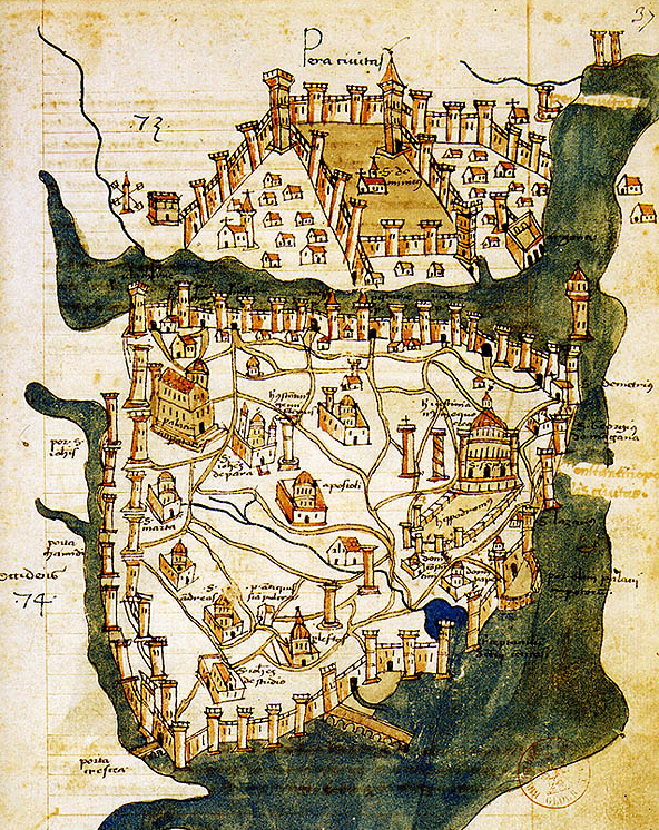
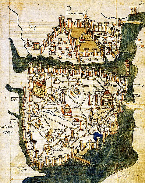
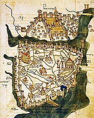
| Popis | Map of Constantinople (a small part of modern Istanbul), called "Historic Peninsula", Tarihi Yarımada en Turkish) designed in 1422 by Florentine cartographer Cristoforo Buondelmonti (Description des îles de l'archipel, Bibliothèque nationale, Paris) is the oldest surviving map of the city, and the only surviving map which predates the Turkish conquest of Constantinople in 1453. | ||||
| Datum | |||||
| Zdroj | Liber insularum Archipelagi (1824), version available at the Bibliothèque nationale de France, Paris | ||||
| Autor | Cristoforo Buondelmonti | ||||
| Svolení (Užití tohoto souboru) |
|
||||
| Další verze |
|
||||

_by_Florentine_cartographer_Cristoforo_Buondelmonte.jpg)
Historie souboru
Kliknutím na datum a čas se zobrazí tehdejší verze souboru.
| Datum a čas | Náhled | Rozměry | Uživatel | Komentář | |
|---|---|---|---|---|---|
| současná | 25. 6. 2007, 12:24 | | 592 × 746 (838 KB) | M.K. | {{Information |Description=Map of Constantinople (1422) by Florentine cartographer Cristoforo Buondelmonte (''Description des îles de l'archipel'', Bibliothèque nationale, Paris) is the oldest surviving map of the city, and the only surviving ma |
Využití souboru
Tento soubor používají následující 2 stránky:
Globální využití souboru
Tento soubor využívají následující wiki:
- Využití na ar.wikipedia.org
- Využití na az.wikipedia.org
- Využití na ba.wikipedia.org
- Využití na bg.wikipedia.org
- Využití na ca.wikipedia.org
- Využití na ce.wikipedia.org
- Využití na de.wikipedia.org
- Využití na el.wikipedia.org
- Využití na en.wikipedia.org
- Bosporus
- Constantinople
- Constantine XI Palaiologos
- John VII Palaiologos
- Walls of Constantinople
- Beyoğlu
- Maiden's Tower
- Siege of Constantinople (1422)
- Siege of Constantinople (1411)
- Template:Did you know nominations/Kontoskalion
- Piyalepaşa, Beyoğlu
- Wikipedia:Main Page history/2019 February 23
- Siege of Constantinople (1394–1402)
- Využití na es.wikipedia.org
- Využití na et.wikipedia.org
- Využití na eu.wikipedia.org
- Využití na fa.wikipedia.org
- Využití na frp.wikipedia.org
- Využití na fr.wikipedia.org
Zobrazit další globální využití tohoto souboru.
_by_Florentine_cartographer_Cristoforo_Buondelmonte.jpg)
_by_Florentine_cartographer_Cristoforo_Buondelmonte.jpg)