Soubor:Latitude Longitude Evaporation minus precipitation.jpg

Velikost tohoto náhledu: 800 × 429 pixelů. Jiná rozlišení: 320 × 172 pixelů | 809 × 434 pixelů.
Původní soubor (809 × 434 pixelů, velikost souboru: 136 KB, MIME typ: image/jpeg)
| Tento soubor pochází z Wikimedia Commons. Níže jsou zobrazeny informace, které obsahuje jeho tamější stránka s popisem souboru. |
Popis
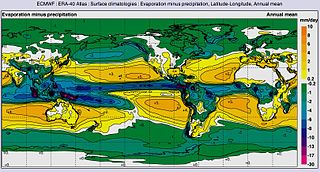
| Popis | Global map of Annual mean Evaporation minus precipitation by Latitude-Longitude | |||||
| Datum | ||||||
| Zdroj | ERA-40 Atlas [1] [2] | |||||
| Autor | NASA & European Centre for Medium-Range Weather Forecasts (ECMWF) | |||||
| Svolení (Užití tohoto souboru) |
|
Licence
| This file is in the public domain in the United States because it was solely created by NASA. NASA copyright policy states that "NASA material is not protected by copyright unless noted". (See Template:PD-USGov, NASA copyright policy page or JPL Image Use Policy.) | ||
 |
Warnings:
|
Původní historie souboru
Původní stránka s popisem souboru byla zde. Všechna následující uživatelská jména odkazují na projekt en.wikipedia.
| Datum a čas | Rozměry | Uživatel | Komentář |
|---|---|---|---|
| 2014-01-28 17:19:25 | 809× 434× | LollyBear12 | {{Information |Description = Evaporation minus precipitation, Latitude-Longitude, Annual meanThis graph shows how the average surface temperature of the world's oceans has changed since 1880. This graph uses the 1971 to 2000 average as a baseline for... |
Historie souboru
Kliknutím na datum a čas se zobrazí tehdejší verze souboru.
| Datum a čas | Náhled | Rozměry | Uživatel | Komentář | |
|---|---|---|---|---|---|
| současná | 5. 11. 2016, 22:18 | | 809 × 434 (136 KB) | Zppix | Transferred from en.wikipedia (MTC!) |
Využití souboru
Tento soubor používají následující 3 stránky:
Globální využití souboru
Tento soubor využívají následující wiki:
- Využití na bg.wikipedia.org
- Využití na ca.wikipedia.org
- Využití na cy.wikipedia.org
- Využití na en.wikipedia.org
- Využití na es.wikipedia.org
- Využití na sr.wikipedia.org
- Využití na tr.wikipedia.org
- Využití na zh.wikipedia.org