Soubor:Landsat 29may03 28m Freeport named.jpg
Velikost tohoto náhledu: 212 × 597 pixelů. Jiná rozlišení: 85 × 240 pixelů | 170 × 480 pixelů | 272 × 768 pixelů | 1 273 × 3 587 pixelů.
Původní soubor (1 273 × 3 587 pixelů, velikost souboru: 838 KB, MIME typ: image/jpeg)
| Tento soubor pochází z Wikimedia Commons. Níže jsou zobrazeny informace, které obsahuje jeho tamější stránka s popisem souboru. |
Popis
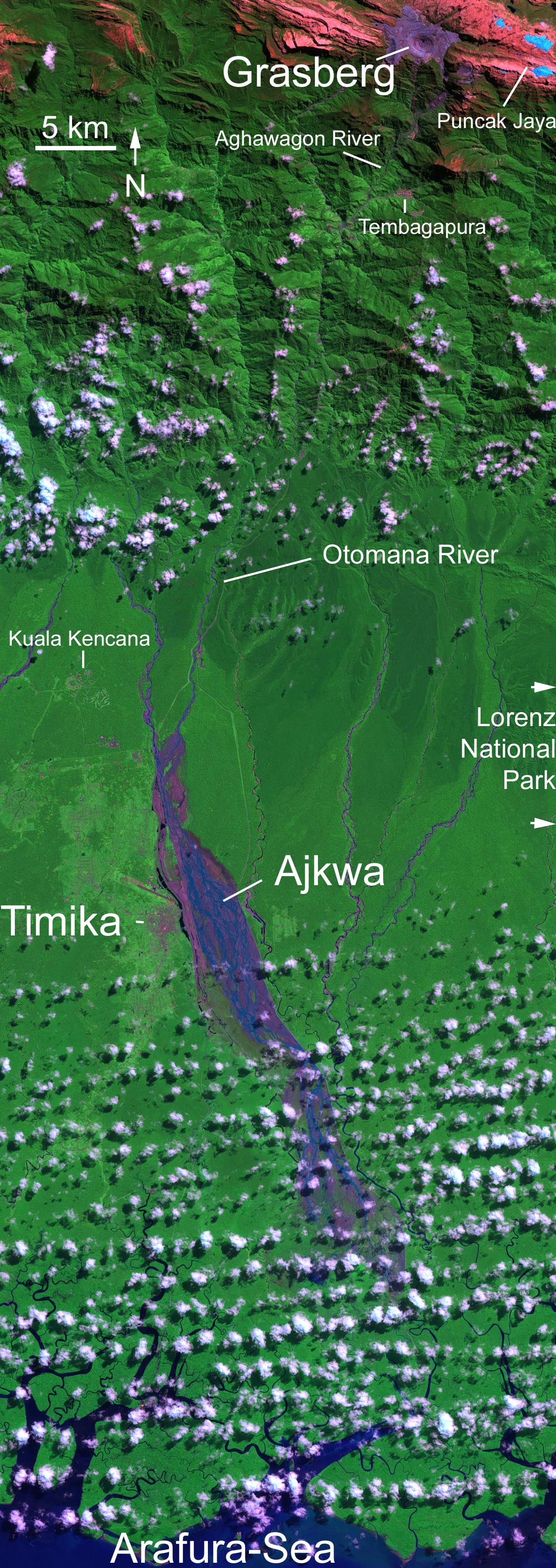
| Popis | Grasberg-Mine in West New Guinea (West Papua). Ausschnitt aus dem hochaufgelösten (6000x6000 Pixel) Landsat-Original, beschriftet. Abraum der Mine in violett, hellblau: Gletscher. Falschfarbene Darstellung. Farben: snow and ice appears blue while clouds are white, bare unvegetated land such as the rocky limestone summit ridges appear red or pinkish, the deep purple and grey is the open pit copper mine while the lush rainforest of the lowlands appears green. In the large format image, runoff into the rivers south of the mine shows up in deep purple, much of which is fine debris washed downstream from the mine. |
| Datum | |
| Zdroj | http://veimages.gsfc.nasa.gov//16923/landsat_carstenz_29may03_28.5m.jpg |
| Autor | Nasa, Landsat 7’s Enhanced Thematic Mapper Plus (ETM+) |
Licence
| This file is in the public domain in the United States because it was solely created by NASA. NASA copyright policy states that "NASA material is not protected by copyright unless noted". (See Template:PD-USGov, NASA copyright policy page or JPL Image Use Policy.) | ||
 |
Warnings:
|
Historie souboru
Kliknutím na datum a čas se zobrazí tehdejší verze souboru.
| Datum a čas | Náhled | Rozměry | Uživatel | Komentář | |
|---|---|---|---|---|---|
| současná | 8. 11. 2006, 05:36 | 1 273 × 3 587 (838 KB) | Echeetah~commonswiki | == Beschreibung == {{Information |Description=Grasberg-Mine in West New Guinea (West Papua). Ausschnitt aus dem hochaufgelösten (6000x6000 Pixel) Landsat-Original, beschriftet. Abraum der Mine in violett, hellblau: Gletscher. Falschfarbene Darstellung. F |
Využití souboru
Tento soubor používá následující stránka:
Globální využití souboru
Tento soubor využívají následující wiki:
- Využití na de.wikipedia.org
- Využití na en.wikipedia.org
- Využití na es.wikipedia.org
- Využití na fr.wikipedia.org
- Využití na id.wikipedia.org
- Využití na it.wikipedia.org
- Využití na ja.wikipedia.org
- Využití na nl.wikipedia.org