Soubor:Lake Titicaca Modis Sensor Nov 4 2001.jpg

Velikost tohoto náhledu: 466 × 599 pixelů. Jiná rozlišení: 187 × 240 pixelů | 373 × 480 pixelů | 597 × 768 pixelů | 796 × 1 024 pixelů | 1 593 × 2 048 pixelů | 2 800 × 3 600 pixelů.
Původní soubor (2 800 × 3 600 pixelů, velikost souboru: 2,06 MB, MIME typ: image/jpeg)
| Tento soubor pochází z Wikimedia Commons. Níže jsou zobrazeny informace, které obsahuje jeho tamější stránka s popisem souboru. |
Popis
| Popis |
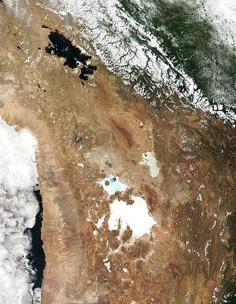
English: MODIS true-color image from November 4, 2001 showing the southern Altiplano including en:Lake Titicaca, the en:Salar de Uyuni, and the en:Salar de Coipasa. |
| Datum | |
| Zdroj |
http://visibleearth.nasa.gov/view_rec.php?id=2317
|
| Autor | Jacques Descloitres, MODIS Land Rapid Response Team, NASA/GSFC |
Licence
| This file is in the public domain in the United States because it was solely created by NASA. NASA copyright policy states that "NASA material is not protected by copyright unless noted". (See Template:PD-USGov, NASA copyright policy page or JPL Image Use Policy.) | ||
 |
Warnings:
|
Původní historie souboru
Původní stránka s popisem souboru byla zde. Všechna následující uživatelská jména odkazují na projekt en.wikipedia.
- 2007-09-20 23:17 Nathancraig 2800×3600×8 (2159740 bytes) MODIS true-color image from November 4, 2001 showing the southern Altiplano including Lake Titicaca, the Salar de Atacama and the Salar de Coipasa.
Historie souboru
Kliknutím na datum a čas se zobrazí tehdejší verze souboru.
| Datum a čas | Náhled | Rozměry | Uživatel | Komentář | |
|---|---|---|---|---|---|
| současná | 12. 1. 2008, 20:13 | | 2 800 × 3 600 (2,06 MB) | File Upload Bot (Magnus Manske) | {{BotMoveToCommons|en.wikipedia}} {{Information |Description={{en|MODIS true-color image from November 4, 2001 showing the southern Altiplano including en:Lake Titicaca, the en:Salar de Atacama, the en:Salar de Uyuni, and the [[:en:Salar d |
Využití souboru
Tento soubor používá následující stránka:
Globální využití souboru
Tento soubor využívají následující wiki:
- Využití na be.wikipedia.org
- Využití na en.wikipedia.org
- Využití na es.wikipedia.org
- Využití na fr.wikipedia.org
- Využití na gl.wikipedia.org
- Využití na he.wikipedia.org
- Využití na hu.wikipedia.org
- Využití na it.wikipedia.org
- Využití na nn.wikipedia.org
- Využití na pt.wikipedia.org
- Využití na ru.wikipedia.org
- Využití na simple.wikipedia.org
- Využití na uk.wikipedia.org