Soubor:Kurarivermap.jpg
Velikost tohoto náhledu: 800 × 467 pixelů. Jiná rozlišení: 320 × 187 pixelů | 640 × 373 pixelů | 1 024 × 598 pixelů | 1 484 × 866 pixelů.
Původní soubor (1 484 × 866 pixelů, velikost souboru: 1,57 MB, MIME typ: image/jpeg)
| Tento soubor pochází z Wikimedia Commons. Níže jsou zobrazeny informace, které obsahuje jeho tamější stránka s popisem souboru. |
Popis
| Popis |
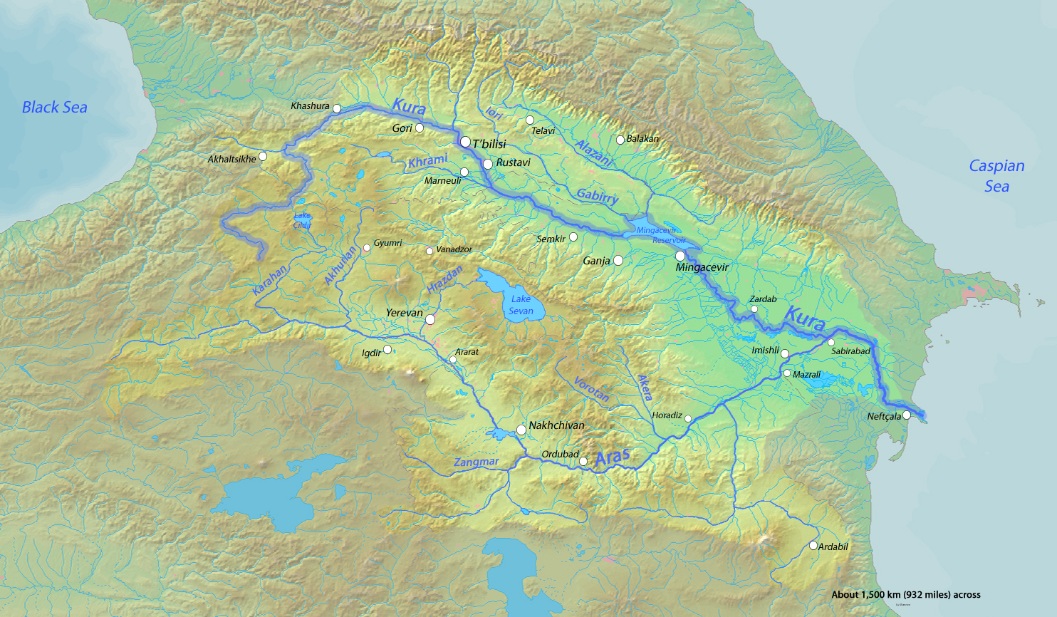
English: Map of the Kura River, whose watershed drains much of the Caucasus region in Azerbaijan, Georgia, Armenia, Turkey and Iran into the Caspian Sea |
| Datum | |
| Zdroj | Background and river course data from http://www2.demis.nl/mapserver/mapper.asp |
| Autor | Shannon |
Licence
Já, držitel autorských práv k tomuto dílu, ho tímto zveřejňuji za podmínek následujících licencí:

|
Tento dokument smí být kopírován, šířen nebo upravován podle podmínek Svobodné licence GNU pro dokumenty verze 1.2 nebo libovolné vyšší verze publikované nadací Free Software Foundation. Dokument nemá neměnné části ani texty na předním či zadním přebalu. Kopie textu licence je k dispozici v oddíle nazvaném GNU Free Documentation License. |
This file is licensed under the Creative Commons Attribution-Share Alike Attribution-Share Alike 4.0 International, 3.0 Unported, 2.5 Generic, 2.0 Generic and 1.0 Generic license.
- Dílo smíte:
- šířit – kopírovat, distribuovat a sdělovat veřejnosti
- upravovat – pozměňovat, doplňovat, využívat celé nebo částečně v jiných dílech
- Za těchto podmínek:
- uveďte autora – Máte povinnost uvést autorství, poskytnout odkaz na licenci a uvést, pokud jste provedli změny. Toho můžete docílit jakýmkoli rozumným způsobem, avšak ne způsobem naznačujícím, že by poskytovatel licence schvaloval nebo podporoval vás nebo vaše užití díla.
- zachovejte licenci – Pokud tento materiál jakkoliv upravíte, přepracujete nebo použijete ve svém díle, musíte své příspěvky šířit pod stejnou nebo slučitelnou licencí jako originál.
Můžete si zvolit libovolnou z těchto licencí.
Historie souboru
Kliknutím na datum a čas se zobrazí tehdejší verze souboru.
| Datum a čas | Náhled | Rozměry | Uživatel | Komentář | |
|---|---|---|---|---|---|
| současná | 18. 10. 2013, 03:16 | | 1 484 × 866 (1,57 MB) | Shannon1 | fixed location of Hrazdan River |
| 12. 3. 2010, 04:47 |  | 1 484 × 866 (783 KB) | Shannon1 | {{Information |Description={{en|1=Map of the Kura River, whose watershed drains much of the Caucasus region in Azerbaijan, Georgia, Armenia, Turkey and Iran into the Caspian Sea}} |Source=Background and river course data from http://www2.demis.nl/mapserve |
Využití souboru
Tento soubor používá následující stránka:
Globální využití souboru
Tento soubor využívají následující wiki:
- Využití na af.wikipedia.org
- Využití na ar.wikipedia.org
- Využití na av.wikipedia.org
- Využití na az.wikipedia.org
- Využití na az.wiktionary.org
- Využití na be.wikipedia.org
- Využití na bg.wikipedia.org
- Využití na ca.wikipedia.org
- Využití na ceb.wikipedia.org
- Využití na da.wikipedia.org
- Využití na de.wikipedia.org
- Využití na en.wikipedia.org
- Využití na eo.wikipedia.org
- Využití na es.wikipedia.org
- Využití na et.wikipedia.org
- Využití na eu.wikipedia.org
- Využití na frr.wikipedia.org
- Využití na fr.wikipedia.org
Zobrazit další globální využití tohoto souboru.