Soubor:Kitchen-21-Russia-Amur-2817.jpg

Velikost tohoto náhledu: 800 × 600 pixelů. Jiná rozlišení: 320 × 240 pixelů | 640 × 480 pixelů | 1 024 × 768 pixelů | 1 280 × 960 pixelů | 2 560 × 1 920 pixelů.
Původní soubor (2 560 × 1 920 pixelů, velikost souboru: 2,03 MB, MIME typ: image/jpeg)
| Tento soubor pochází z Wikimedia Commons. Níže jsou zobrazeny informace, které obsahuje jeho tamější stránka s popisem souboru. |
| Popis |
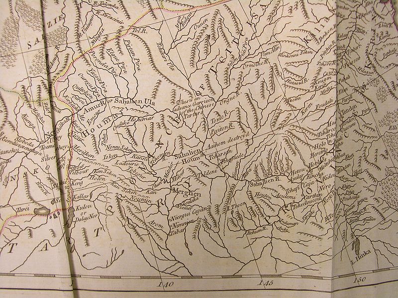
English: A fragment of the map of Russian Empire (pages 21-22), said to be based on d'Anville's work, in Thomas Kithen's "Atlas describing the Whole Universe"
English: The upper and middle Amur region, then part of "Chinese Tartary", and the adjacent parts of Russian Empire |
||||||||||||||||||||
| Datum | |||||||||||||||||||||
| Zdroj |
English: "A General Atlas describing the whole Universe, being a Compleat and New Collection of the most approved Maps extant; Corrected with utmost Care, and augmented from the latest Discoveries; the whole thing being an Improvement of the Maps of d'Anville and Robert. Engraved in the best Manner on Sixty-Two Copper Plates, By Thomas Kitchen, Senior, and Others". "London: Printed for Robert Sayer, Map and Printseller, at No. 53, in Fleet-Street. MDCCLXXIII" (i.e., 1773). Each map in the atlas has its particular author indicated as well.
Русский: "Общий атлас всей Вселенной", изданный в Лондоне в 1773 г. Издатель Томас Китчен. |
||||||||||||||||||||
| Autor |
|
||||||||||||||||||||
| Svolení (Užití tohoto souboru) |
Author died more than 70 years ago - public domain | ||||||||||||||||||||

|
Toto dílo je volné také v zemích, jejichž právní řád chrání majetková autorská práva po dobu života autora a 100 let po jeho smrti. | |
| Bylo zjištěno, že u tohoto souboru nejsou známa žádná omezení daná autorským právem a právy s ním souvisejícími. | |
Historie souboru
Kliknutím na datum a čas se zobrazí tehdejší verze souboru.
| Datum a čas | Náhled | Rozměry | Uživatel | Komentář | |
|---|---|---|---|---|---|
| současná | 5. 4. 2009, 09:51 | | 2 560 × 1 920 (2,03 MB) | Vmenkov | {{Information |Description={{en|A fragment of the map of Russian Empire (pages 21-22), said to be based on d'Anville's work, in Thomas Kithen's "Atlas describing the Whole Universe"}} {{en|The upper and Middle Amur region, then part of "Chinese Tartary"} |
Využití souboru
Tento soubor používá následující stránka:
Globální využití souboru
Tento soubor využívají následující wiki:
- Využití na arz.wikipedia.org
- Využití na bg.wikipedia.org
- Využití na ca.wikipedia.org
- Využití na ceb.wikipedia.org
- Využití na en.wikipedia.org
- Využití na et.wikipedia.org
- Využití na fa.wikipedia.org
- Využití na it.wikipedia.org
- Využití na pl.wikipedia.org
- Využití na ru.wikipedia.org
- Využití na sv.wikipedia.org
- Využití na ur.wikipedia.org
- Využití na vi.wikipedia.org
- Využití na www.wikidata.org
- Využití na zh.wikipedia.org