Soubor:King George Island map-en.svg

Velikost tohoto PNG náhledu tohoto SVG souboru: 661 × 403 pixelů. Jiná rozlišení: 320 × 195 pixelů | 640 × 390 pixelů | 1 024 × 624 pixelů | 1 280 × 780 pixelů | 2 560 × 1 561 pixelů.
Původní soubor (soubor SVG, nominální rozměr: 661 × 403 pixelů, velikost souboru: 209 KB)
| Tento soubor pochází z Wikimedia Commons. Níže jsou zobrazeny informace, které obsahuje jeho tamější stránka s popisem souboru. |
| Popis |
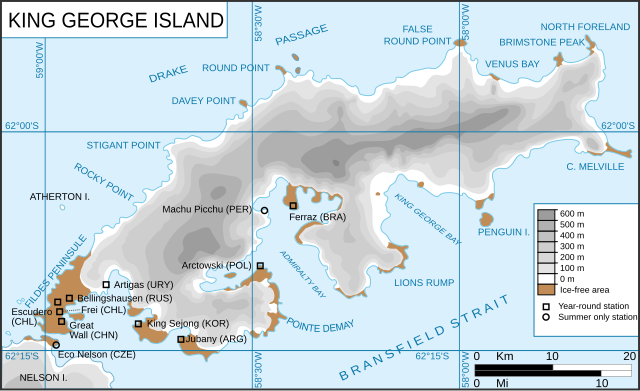
King George Island map. Detailed. Relief. Research Stations. Français : Carte de l'île du Roi-George. Relief et stations de recherches English: King George Island map. Detailed. Relief. Research Stations. |
| Datum | (UTC) |
| Zdroj | |
| Autor |
|
| Další verze |
Díla odvozená od tohoto souboru: |
.svg)
.svg)
| Toto je upravený obrázek, což znamená, že byl oproti původní verzi digitálně změněn. Úpravy: english version of the french one. Původní verzi je možné zhlédnout zde: Ile du roi-George (carte-fr).svg. Úpravy provedl Treehill.
|
Tento soubor podléhá licenci Creative Commons Uveďte autora-Zachovejte licenci 3.0 Unported
- Dílo smíte:
- šířit – kopírovat, distribuovat a sdělovat veřejnosti
- upravovat – pozměňovat, doplňovat, využívat celé nebo částečně v jiných dílech
- Za těchto podmínek:
- uveďte autora – Máte povinnost uvést autorství, poskytnout odkaz na licenci a uvést, pokud jste provedli změny. Toho můžete docílit jakýmkoli rozumným způsobem, avšak ne způsobem naznačujícím, že by poskytovatel licence schvaloval nebo podporoval vás nebo vaše užití díla.
- zachovejte licenci – Pokud tento materiál jakkoliv upravíte, přepracujete nebo použijete ve svém díle, musíte své příspěvky šířit pod stejnou nebo slučitelnou licencí jako originál.
Původní historie souboru
This image is a derivative work of the following images:
- File:Kgeorge_map.png licensed with Cc-by-sa-3.0-migrated, GFDL
- 2008-01-22T13:13:50Z Wadim 660x402 (303141 Bytes) {{Information |Description= King George Island map. Detailed. Relief. Research Stations. Modificado 22.01.2008: Quito la firma, añado denominación historica en ruso. |Source= |Date= 06-May-2006 |Author= Giovanni Fattori |P
- 2006-05-06T17:51:48Z Gi 660x402 (307135 Bytes) {{Information |Description= King George Island map. Detailed. Relief. Research Stations. |Source= |Date= 06-May-2006 |Author= Giovanni Fattori |Permission= GNU free licence |other_versions= }}
- File:Ile_du_roi-George_(carte-fr).svg licensed with Cc-by-sa-3.0-migrated, GFDL
- 2010-04-18T21:10:06Z Trex 661x403 (266284 Bytes) {{Information |Description={{fr|1=Carte de l'île du Roi-George. Relief et stations de recherches}} {{en|1=King George Island map. Detailed. Relief. Research Stations.}} |Source=*[[:File:Kgeorge_map.png|]] |Date=2010-04-18 21:07
Uploaded with derivativeFX
Historie souboru
Kliknutím na datum a čas se zobrazí tehdejší verze souboru.
| Datum a čas | Náhled | Rozměry | Uživatel | Komentář | |
|---|---|---|---|---|---|
| současná | 14. 6. 2010, 14:22 | | 661 × 403 (209 KB) | Treehill | {{Information |Description=King George Island map. Detailed. Relief. Research Stations. {{fr|Carte de l'île du Roi-George. Relief et stations de recherches}} {{en|King George Island map. Detailed. Relief. Research Stations.}} |Source=*[[:File:Kgeorge_map |
Využití souboru
Tento soubor používá následující stránka:
Globální využití souboru
Tento soubor využívají následující wiki:
- Využití na ar.wikipedia.org
- Využití na ca.wikipedia.org
- Využití na en.wikipedia.org
- King George Island (South Shetland Islands)
- Fildes Peninsula
- Base Presidente Eduardo Frei Montalva
- Trinity Church (Antarctica)
- Anna Glacier
- Baranowski Glacier
- Usher Glacier
- Noble Glacier
- Krak Glacier
- Domeyko Glacier
- Poetry Glacier
- Polar Club Glacier
- Ecology Glacier
- Eldred Glacier
- Flagstaff Glacier
- Goetel Glacier
- Stenhouse Glacier
- Lange Glacier
- Využití na es.wikipedia.org
- Využití na fr.wikipedia.org
- Využití na he.wikipedia.org
- Využití na it.wikipedia.org
- Využití na ka.wikipedia.org
- Využití na mk.wikipedia.org
- Využití na nl.wikipedia.org
- Využití na nn.wikipedia.org
- Využití na no.wikipedia.org
- Využití na pt.wikipedia.org
- Využití na sr.wikipedia.org
- Využití na tr.wikipedia.org
- Využití na uk.wikipedia.org
- Využití na uz.wikipedia.org
Zobrazit další globální využití tohoto souboru.