Soubor:Hvidovre from highrise "Store Hus" in Avedøre.jpg

Původní soubor (2 592 × 1 944 pixelů, velikost souboru: 3,54 MB, MIME typ: image/jpeg)
| Tento soubor pochází z Wikimedia Commons. Níže jsou zobrazeny informace, které obsahuje jeho tamější stránka s popisem souboru. |
Popis
| Popis |
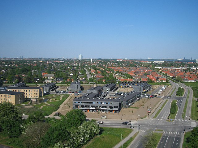
English: the far left the black highrise is the Ferring building in Ørestad.
The blue tower in the middle is the gas-silo in Valby. The city-walk was very interesting, and we were given insights into the thinking, or lack of, of the city planners. They did have a huge challenge, Denmark was lacking 100,000 housing units, and they managed to deliver, the downside was that it produced the endless concrete landscapes, that the planners and architects themself wouldn't live in themself. The planned citys were also hurt by changing conditions, by the time "Avedøre Stationsby" was finished we were in a recession, and public housing was hit by the crisis because they were forced to house marginalised people in cities like this. Forstadsmuseet, the Museum of suburbia, that organised the city-walk also has a flickr accout: www.flickr.com/photos/forstadsmuseet/ |
| Datum | |
| Zdroj | View of Hvidovre from highrise "Store Hus" in Avedøre |
| Autor | Kim Bach from Taastrup, Denmark |
| Pozice fotografa | | Tento snímek a mnohé další na: OpenStreetMap |
|---|
Licence
- Dílo smíte:
- šířit – kopírovat, distribuovat a sdělovat veřejnosti
- upravovat – pozměňovat, doplňovat, využívat celé nebo částečně v jiných dílech
- Za těchto podmínek:
- uveďte autora – Máte povinnost uvést autorství, poskytnout odkaz na licenci a uvést, pokud jste provedli změny. Toho můžete docílit jakýmkoli rozumným způsobem, avšak ne způsobem naznačujícím, že by poskytovatel licence schvaloval nebo podporoval vás nebo vaše užití díla.
- zachovejte licenci – Pokud tento materiál jakkoliv upravíte, přepracujete nebo použijete ve svém díle, musíte své příspěvky šířit pod stejnou nebo slučitelnou licencí jako originál.
| This image was originally posted to Flickr by Kim Bach at https://flickr.com/photos/63934584@N00/7258525294. It was reviewed on 29. ledna 2017 by FlickreviewR and was confirmed to be licensed under the terms of the cc-by-sa-2.0. |
Historie souboru
Kliknutím na datum a čas se zobrazí tehdejší verze souboru.
| Datum a čas | Náhled | Rozměry | Uživatel | Komentář | |
|---|---|---|---|---|---|
| současná | 29. 1. 2017, 11:40 | | 2 592 × 1 944 (3,54 MB) | Ramblersen | the far left the black highrise is the Ferring building in Ørestad. The blue tower in the middle is the gas-silo in Valby. The city-walk was very interesting, and we were given insights into the thinking, or lack of, of the city planners. They did h... |
Využití souboru
Tento soubor používá následující stránka:
Globální využití souboru
Tento soubor využívají následující wiki: