Soubor:Himalaya annotated.jpg

Velikost tohoto náhledu: 800 × 530 pixelů. Jiná rozlišení: 320 × 212 pixelů | 640 × 424 pixelů | 1 000 × 662 pixelů.
Původní soubor (1 000 × 662 pixelů, velikost souboru: 413 KB, MIME typ: image/jpeg)
| Tento soubor pochází z Wikimedia Commons. Níže jsou zobrazeny informace, které obsahuje jeho tamější stránka s popisem souboru. |
| Popis |
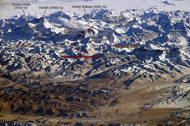
English: The Himalayan mountain range with Mount Everest as seen from the International Space Station looking south-south-east over the Tibetan Plateau. Four of the world's fourteen eight-thousanders, mountains higher than 8000 metres, can be seen, Makalu (8462 m), Everest (8850 m), Lhotse (8516 m) and Cho Oyu (8201 m). The South Col Route is Mount Everest's most often used climbing route. |
|||||
| Zdroj |
This image is a modified version of this NASA Image. Annotations have been added by Janderk Jan Derk. If anyone finds errors please leave a note in the discussions area of this page. Original image: NASA |
|||||
| Autor | NASA, Janderk Jan Derk | |||||
| Svolení (Užití tohoto souboru) |
|
|||||
| Další verze |
Tento soubor byl odvozen z: Himalayas.jpg |

Historie souboru
Kliknutím na datum a čas se zobrazí tehdejší verze souboru.
| Datum a čas | Náhled | Rozměry | Uživatel | Komentář | |
|---|---|---|---|---|---|
| současná | 7. 12. 2006, 00:39 | | 1 000 × 662 (413 KB) | Janderk~commonswiki | Slight change in Nuptse location to try to make it point more to Nuptse I. |
| 5. 12. 2006, 14:08 |  | 1 000 × 662 (414 KB) | Janderk~commonswiki | Fixed errors. See talk page. | |
| 19. 2. 2005, 20:23 |  | 1 000 × 662 (416 KB) | RedWolf | Himalaya - annotated |
Využití souboru
Tento soubor používá následujících 5 stránek:
Globální využití souboru
Tento soubor využívají následující wiki:
- Využití na af.wikipedia.org
- Využití na anp.wikipedia.org
- Využití na ast.wikipedia.org
- Využití na awa.wikipedia.org
- Využití na azb.wikipedia.org
- Využití na az.wikipedia.org
- Využití na ba.wikipedia.org
- Využití na bcl.wikipedia.org
- Využití na beta.wikiversity.org
- Využití na be.wikipedia.org
- Využití na bg.wikipedia.org
- Využití na blk.wikipedia.org
- Využití na bn.wikipedia.org
- Využití na bs.wikipedia.org
- Využití na ca.wikipedia.org
- Využití na ckb.wikipedia.org
- Využití na csb.wikipedia.org
- Využití na da.wikipedia.org
- Využití na de.wikipedia.org
- Využití na el.wikipedia.org
- Využití na en.wikipedia.org
- Využití na eo.wikipedia.org
- Využití na es.wikipedia.org
Zobrazit další globální využití tohoto souboru.