Soubor:Greenland.A2004208.1810.250m.jpg

Velikost tohoto náhledu: 800 × 600 pixelů. Jiná rozlišení: 320 × 240 pixelů | 640 × 480 pixelů | 1 024 × 768 pixelů | 1 280 × 960 pixelů | 2 560 × 1 920 pixelů | 3 200 × 2 400 pixelů.
Původní soubor (3 200 × 2 400 pixelů, velikost souboru: 1,11 MB, MIME typ: image/jpeg)
| Tento soubor pochází z Wikimedia Commons. Níže jsou zobrazeny informace, které obsahuje jeho tamější stránka s popisem souboru. |
Popis
| Popis |
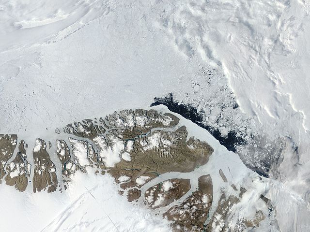
English: Northern Greenland (Peary Land): Moderate Resolution Imaging Spectroradiometer (MODIS) on NASA’s Terra satellite |
| Datum | |
| Zdroj | http://visibleearth.nasa.gov/view.php?id=71935 |
| Autor | NASA |
Licence
| This file is in the public domain in the United States because it was solely created by NASA. NASA copyright policy states that "NASA material is not protected by copyright unless noted". (See Template:PD-USGov, NASA copyright policy page or JPL Image Use Policy.) | ||
 |
Warnings:
|
| Poznámky | K tomuto souboru existují poznámky: Prohlédnout si poznámky na Commons |
Historie souboru
Kliknutím na datum a čas se zobrazí tehdejší verze souboru.
| Datum a čas | Náhled | Rozměry | Uživatel | Komentář | |
|---|---|---|---|---|---|
| současná | 18. 7. 2012, 08:06 | | 3 200 × 2 400 (1,11 MB) | Ratzer | {{Information |Description ={{en|1=Northern Greenland (Peary Land): Moderate Resolution Imaging Spectroradiometer (MODIS) on NASA’s Terra satellite}} |Source =http://visibleearth.nasa.gov/view.php?id=71935 |Author =NASA |Date ... |
Využití souboru
Tento soubor používá následující stránka:
Globální využití souboru
Tento soubor využívají následující wiki:
- Využití na be.wikipedia.org
- Využití na ca.wikipedia.org
- Využití na ceb.wikipedia.org
- Využití na da.wikipedia.org
- Využití na de.wikipedia.org
- Využití na en.wikipedia.org
- Peary Land
- Independence I culture
- Sverdrup Island (Greenland)
- East Jensen Island
- Hazenland
- John Murray Island
- Princess Dagmar Island
- Princess Thyra Island
- Borup Island
- Stephenson Island (Greenland)
- Princess Margaret Island
- De Long Fjord
- Beaumont Island (Greenland)
- Roosevelt Range
- Johannes V. Jensen Land
- Nansen Land
- Stjernebannertinde
- Roosevelt Land
- Amundsen Land
- Melville Land
- Herluf Trolle Land
Zobrazit další globální využití tohoto souboru.