Soubor:Greek Macedonia map with subdivisions.svg

Velikost tohoto PNG náhledu tohoto SVG souboru: 599 × 600 pixelů. Jiná rozlišení: 240 × 240 pixelů | 479 × 480 pixelů | 767 × 768 pixelů | 1 023 × 1 024 pixelů | 2 045 × 2 048 pixelů | 736 × 737 pixelů.
Původní soubor (soubor SVG, nominální rozměr: 736 × 737 pixelů, velikost souboru: 1,78 MB)
| Tento soubor pochází z Wikimedia Commons. Níže jsou zobrazeny informace, které obsahuje jeho tamější stránka s popisem souboru. |
| Popis |
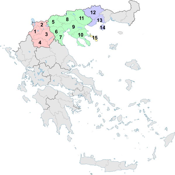
English: The Greek region of Macedonia, and its subdivisions into Peripheries and Peripheral Units as of 2011. |
| Datum | (UTC) |
| Zdroj | |
| Autor |
|
| Další verze |
Díla odvozená od tohoto souboru: |
Já, držitel autorských práv k tomuto dílu, ho tímto zveřejňuji za podmínek následující licence:
Tento soubor podléhá licenci Creative Commons Uveďte autora-Zachovejte licenci 3.0 Unported
- Dílo smíte:
- šířit – kopírovat, distribuovat a sdělovat veřejnosti
- upravovat – pozměňovat, doplňovat, využívat celé nebo částečně v jiných dílech
- Za těchto podmínek:
- uveďte autora – Máte povinnost uvést autorství, poskytnout odkaz na licenci a uvést, pokud jste provedli změny. Toho můžete docílit jakýmkoli rozumným způsobem, avšak ne způsobem naznačujícím, že by poskytovatel licence schvaloval nebo podporoval vás nebo vaše užití díla.
- zachovejte licenci – Pokud tento materiál jakkoliv upravíte, přepracujete nebo použijete ve svém díle, musíte své příspěvky šířit pod stejnou nebo slučitelnou licencí jako originál.
Uploaded with derivativeFX
Historie souboru
Kliknutím na datum a čas se zobrazí tehdejší verze souboru.
| Datum a čas | Náhled | Rozměry | Uživatel | Komentář | |
|---|---|---|---|---|---|
| současná | 10. 2. 2019, 16:24 | | 736 × 737 (1,78 MB) | Sarah fides | Hopefully this fixes the annoying black line that keeps appearing off the Ionian islands |
| 10. 2. 2019, 16:21 |  | 736 × 737 (1,79 MB) | Sarah fides | Cleanup | |
| 28. 7. 2011, 00:25 |  | 7 304 × 7 315 (1,79 MB) | Sarah fides | {{Information |Description={{en|1=The Greek region of Macedonia, and its subdivisions into Peripheries and Peripheral Units as of 2011.}} |Source=*File:Greece_2011_Periferiakes_Enotites.svg |Date=2011-07-27 22:23 (UTC) |Author=*[[:File:Greece_2011_P |
Využití souboru
Tento soubor nepoužívá žádná stránka.
Globální využití souboru
Tento soubor využívají následující wiki:
- Využití na de.wikipedia.org
- Využití na el.wikipedia.org
- Využití na el.wikivoyage.org
- Využití na en.wikipedia.org
- Využití na et.wikipedia.org
- Využití na fi.wikipedia.org
- Využití na fr.wikivoyage.org
- Využití na hr.wikipedia.org
- Využití na lt.wikipedia.org
- Využití na nn.wikipedia.org
- Využití na vi.wikipedia.org