Soubor:Geologic Map of the Near Side of the Moon CROP.jpg
Velikost tohoto náhledu: 517 × 599 pixelů. Jiná rozlišení: 207 × 240 pixelů | 414 × 480 pixelů | 662 × 768 pixelů | 883 × 1 024 pixelů | 1 767 × 2 048 pixelů | 4 094 × 4 746 pixelů.
Původní soubor (4 094 × 4 746 pixelů, velikost souboru: 4,37 MB, MIME typ: image/jpeg)
| Tento soubor pochází z Wikimedia Commons. Níže jsou zobrazeny informace, které obsahuje jeho tamější stránka s popisem souboru. |
Popis
| Popis |
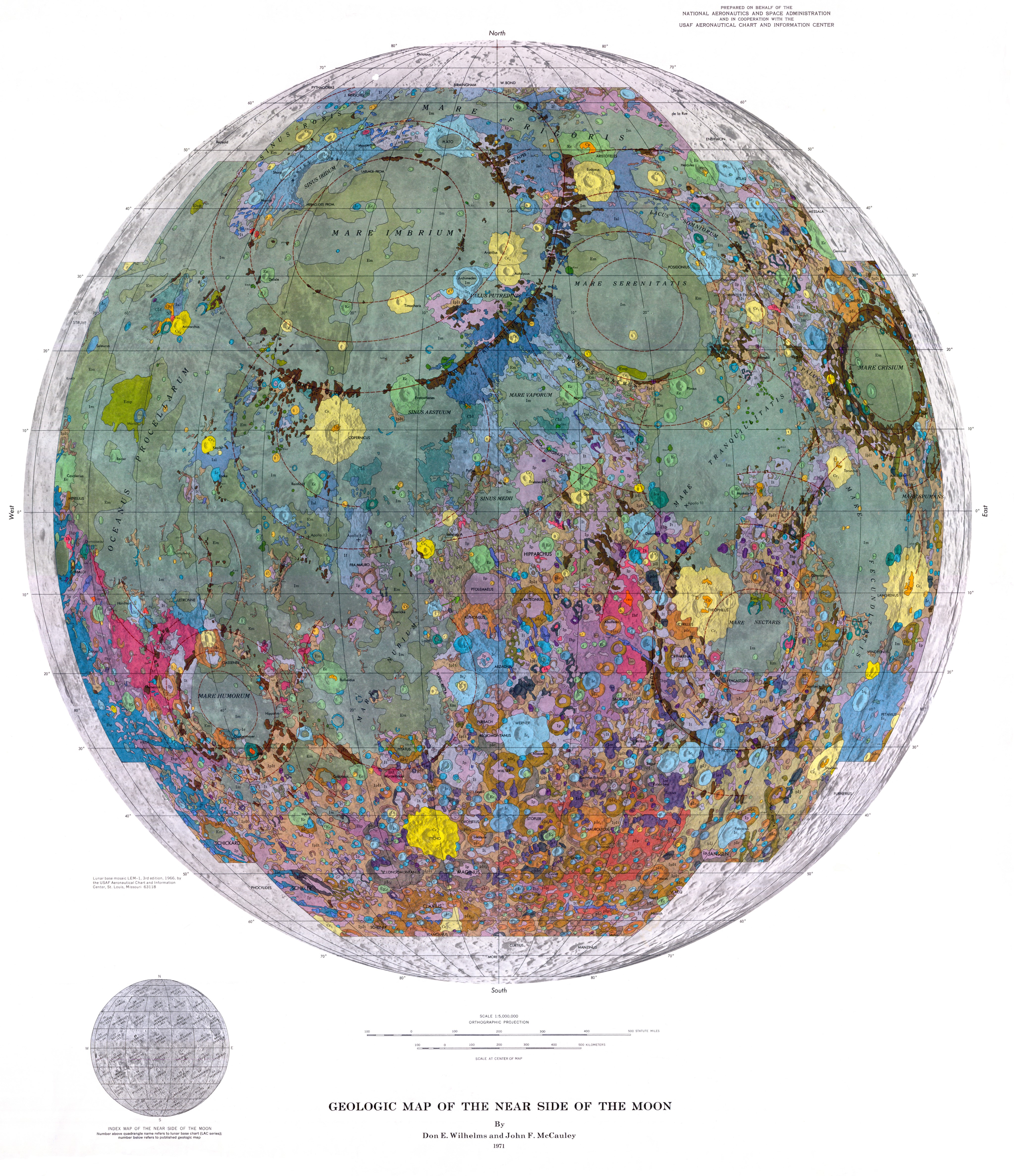
English: By Don E. Wilhelms and John F. McCauley
Prepared on behalf of the National Aeronautics and Space Administration (NASA) and in cooperation with the USAF Aeronautical Chart and Information Center (Now part of the U.S. Department of Defense's National Geospatial-Intelligence Agency) The chief purpose of the 1 :5,000,000-scale map is to summarize the current state of lunar geologic knowledge as developed from the U.S. Geological Survey's systematic lunar mapping program, which began in 1960. Like terrestrial synoptic maps it provides a stratigraphic framework to be used for developing new theory and for determining the regional significance of surface exploration results. The geologic summary which accompanies the map gives the major genetic and historical conclusions which stem from the work. The map explanation provides the descriptive details that led to these conclusions. This pamphlet discusses the rationale methods, and nomenclature of lunar stratigraphy: specifically for those interested in why and how the map was produced. The work is based both on results of the telescopic mapping program and on data from the unmanned lunar exploration program, particularly the regional coverage of Lunar Orbiter IV1 The early telescopic studies established the geologic heterogeneity of the Moon and produced a workable nearside stratigraphy (Shoemaker and Hackman, 1962; McCauley, 1967b; Wilhelms, 1970b). Prior to the Lunar Orbiters, telescopic resolution limitations dictated emphasis on the grosser aspects of lunar geology: the structures and ejecta blankets associated with the multiringed basins, the major craters, and the stratigraphic relations between the generally younger maria and older terrae. The main products of the telescopic work were 36 1:1 ,000,000-scale geologic quadrangle maps and a 1 :5,000,000-scale preliminary map of the region 32°N. to 32°S. and 70°E. to 70°W. (Wilhelms, Trask, and Keith, 1965). Before the systematic program began, Hackman and Mason (1961) produced a set of three nearside maps at a scale of 1:3,800,000 from telescopic data; these maps emphasized the geology, physiography and ray-crater distribution. |
| Datum | |
| Zdroj | https://www.lpi.usra.edu/resources/mapcatalog/usgs/ |
| Autor | Don E. Wilhems and John F. McCauley (USGS) |
Licence
Toto dílo je ve Spojených státech volným dílem, protože jde o dílo úřadů americké federální vlády podle ustanovení Hlavy 17, Kapitoly 1, Sekce 105 amerického právního řádu. Viz Autorské právo.
Upozornění: uvedené se vztahuje pouze na díla úřadů federální vlády, nikoliv na úřady jednotlivých států, okresů, či nižších územně správních jednotek.
|
 | |
| Bylo zjištěno, že u tohoto souboru nejsou známa žádná omezení daná autorským právem a právy s ním souvisejícími. | ||
Historie souboru
Kliknutím na datum a čas se zobrazí tehdejší verze souboru.
| Datum a čas | Náhled | Rozměry | Uživatel | Komentář | |
|---|---|---|---|---|---|
| současná | 15. 4. 2021, 23:36 | | 4 094 × 4 746 (4,37 MB) | Bridgman | Uploaded a work by Don E. Wilhems and John F. McCauley (USGS) from https://www.lpi.usra.edu/resources/mapcatalog/usgs/ with UploadWizard |
Využití souboru
Tento soubor používá následující stránka:
Globální využití souboru
Tento soubor využívají následující wiki:
- Využití na en.wikiquote.org
- Využití na nl.wikipedia.org