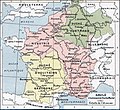
Soubor:Francia at the death of Pepin of Heristal, 714.jpg

Původní soubor(1 254 × 1 149 pixelů, velikost souboru: 1 MB, MIME typ: image/jpeg)

Popis

Popis
English: Francia at the death of Pepin of Heristal, 714
Français : Gaule à l'avènement de Charles Martel (714).
Datum
Zdroj Paul Vidal de la Blache's Atlas général d'histoire et de géographie (1912). The original scanned image can be found at http://www.hipkiss.org/data/maps/vidal-lablache_atlas-general-histoire-et-geographie_1912_ancient-gaul-merovian-merovingienne_2953_4252_600.jpg. Information on the original scan can be found at http://www.hipkiss.org/cgi-bin/maps.pl?book=Vidal%20Lablache%20-%20Atlas%20General%20Histoire%20Et%20Geographie.
Autor
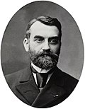
Paul Vidal de la Blache  (1845–1918)  wikidata:Q311865 s:fr:Auteur:Paul Vidal de La Blache q:fr:Paul Vidal de La Blache
 
Paul Vidal de la Blache
Pseudonym
Vidal de la Blache; Paul Vidal de Lablache; Paul-Marie-Joseph Vidal de La Blache; Vidal-Lablache
Popis francouzský geograf a kartograf
Datum narození / úmrtí 22. ledna 1845 Edit this at Wikidata 5. dubna 1918 Edit this at Wikidata
Místo narození / úmrtí Pézenas La Seyne-sur-Mer
Soubor autorit
creator QS:P170,Q311865
Další verze
K tomuto obrázku existuje vektorová verze (v SVG). Pokud je lepší, používejte raději tu.

File:Francia at the death of Pepin of Heristal, 714.jpg → File:Francia at the death of Pepin of Heristal 714-es.svg

Podrobnější informace o vektorové grafice najdete na stránce Commons:Transition to SVG.
Také si můžete přečíst informace o podpoře formátu SVG v MediaWiki.

V jiných jazycích
Alemannisch  Bahasa Indonesia  Bahasa Melayu  British English  català  čeština  dansk  Deutsch  eesti  English  español  Esperanto  euskara  français  Frysk  galego  hrvatski  Ido  italiano  lietuvių  magyar  Nederlands  norsk bokmål  norsk nynorsk  occitan  Plattdüütsch  polski  português  português do Brasil  română  Scots  sicilianu  slovenčina  slovenščina  suomi  svenska  Tiếng Việt  Türkçe  vèneto  Ελληνικά  беларуская (тарашкевіца)  български  македонски  нохчийн  русский  српски / srpski  татарча/tatarça  українська  ქართული  հայերեն  বাংলা  தமிழ்  മലയാളം  ไทย  한국어  日本語  简体中文  繁體中文  עברית  العربية  فارسی  +/−
Nový obrázek ve formátu SVG

Licence

Tento obrázek je volným dílem, protože se jedná jen o mechanický sken či fotokopii originálu volného díla anebo se jedná o dílo, jež se evidentně takovému skenu či fotokopii podobá natolik, že nemůže požívat ochrany autorského práva. Originál samotný je volným dílem z následujícího důvodu:
Public domain

Autor zemřel v roce 1918, takže toto dílo je volné také v zemích, jejichž právní řád chrání majetková autorská práva po dobu života autora a 100 let po jeho smrti.


Toto dílo je ve Spojených státech amerických dílem volným (public domain), protože tam bylo registrováno u U.S. Copyright Office nebo zveřejněno před 1. lednem 1929.


This tag is designed for use where there may be a need to assert that any enhancements (eg brightness, contrast, colour-matching, sharpening) are in themselves insufficiently creative to generate a new copyright. It can be used where it is unknown whether any enhancements have been made, as well as when the enhancements are clear but insufficient. For known raw unenhanced scans you can use an appropriate {{PD-old}} tag instead. For usage, see Commons:When to use the PD-scan tag.


Note: This tag applies to scans and photocopies only. For photographs of public domain originals taken from afar, {{PD-Art}} may be applicable. See Commons:When to use the PD-Art tag.

Původní historie souboru

The original description page is/was here. All following user names refer to en.wikipedia.

  • 2007-08-19 21:33 Srnec 1241×1136×8 (353954 bytes) The map comes from Vidal-Lablache, ''Atlas général d'histoire et de géographie'' (1894). {{PD-art-life-70}}
  • 2007-09-10 16:34 Earthsound 1254 × 1149×8 (1 MB) Gaule at the time of Charles Martel (714). The scale is 1:12,000,000 This is a straightened and color balanced crop of a scan of a map from Paul Vidal de la Blache's 'Atlas général d'histoire et de géograp. {{PD-art-life-70}}

Popisky

Přidejte jednořádkové vysvětlení, co tento soubor představuje

Položky vyobrazené v tomto souboru

zobrazuje

Historie souboru

Kliknutím na datum a čas se zobrazí tehdejší verze souboru.

Datum a časNáhledRozměryUživatelKomentář
současná21. 9. 2019, 16:26Náhled verze z 21. 9. 2019, 16:261 254 × 1 149 (1 MB)OgreBot(BOT): Reverting to most recent version before archival
21. 9. 2019, 16:26Náhled verze z 21. 9. 2019, 16:261 241 × 1 148 (349 KB)OgreBot(BOT): Uploading old version of file from en.wikipedia; originally uploaded on 2007-08-19 21:41:17 by Srnec
22. 1. 2008, 21:23Náhled verze z 22. 1. 2008, 21:231 254 × 1 149 (1 MB)Vladimir Solovjev{{Information |Description={{en|This is a straightened and color balanced crop of a scan of a map from Paul Vidal de la Blache's ''Atlas général d'histoire et de géographie'' (1912).}} |Source=Transfered from [http://en.wikipedia.org

Tento soubor používají následující 3 stránky:

Globální využití souboru

Tento soubor využívají následující wiki:

Zobrazit další globální využití tohoto souboru.