Soubor:Flag of Bosnia and Herzegovina (construction sheet).svg

Původní soubor (soubor SVG, nominální rozměr: 1 290 × 690 pixelů, velikost souboru: 16 KB)
| Tento soubor pochází z Wikimedia Commons. Níže jsou zobrazeny informace, které obsahuje jeho tamější stránka s popisem souboru. |
.svg)
Popis
| Popis |
English: Flag of Bosnia and Herzegovina — construction sheet |
| Datum | |
| Zdroj |
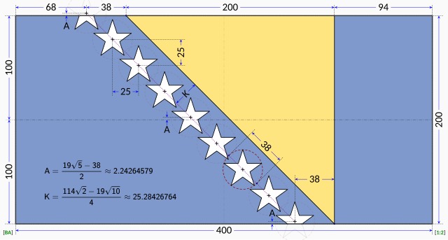
Vlastní dílo. This construction sheet is derived from multiple sources:
The specification drawing provides:
The triangle is isosceles with one edge running at 45° relative to the edges of the flag. According to the law, the stars are supposed to parallel to the triangle's edge, so it stands that the line of stars must run in a precise 45° line. The law does not explicitly dictate the precise placement of the stars. Close examination of the government EPS drawing reveals most of the intended geometry:
The only missing information is the precise horizontal positioning of the line of stars. Based on measurements from the government EPS drawing, the vertical centerline of the centre star is located at distance from the hoist that is roughly 42.4% of the length of the flag. The centre star was chosen for the measurement because the line of stars in the EPS drawing runs at about 45.5° instead of the 45° dictated by the law. The same measurement repeated on the specification drawing reveals a distance of about 41.8% of the length of the flag with the line of stars again at 45.5°. For the purpose of this Wikimedia construction sheet, the distance from the hoist to the vertical centerline of the centre star is assumed to be exactly 42.0% of the length of the flag. All the other stars are laid out with equal spacing on a precise 45° degree line. Vertical coordinates of the stars are controlled by the intersections of the top and bottom stars with the flag edges. |
| Autor | MapGrid |
Licence

|
Tento obrázek zobrazuje vlajku, znak, pečeť nebo jinou insignii. Použití či užívání těchto symbolů je v mnoha zemích omezeno právními normami. Tato omezení jsou nezávislá na autorském právu. |
| Já, autor tohoto díla, jej tímto uvolňuji jako volné dílo, a to celosvětově. V některých zemích to není podle zákona možné; v takovém případě: Poskytuji komukoli právo užívat toto dílo za libovolným účelem, a to bezpodmínečně s výjimkou podmínek vyžadovaných zákonem. |
Historie souboru
Kliknutím na datum a čas se zobrazí tehdejší verze souboru.
| Datum a čas | Náhled | Rozměry | Uživatel | Komentář | |
|---|---|---|---|---|---|
| současná | 17. 1. 2023, 15:58 | | 1 290 × 690 (16 KB) | MapGrid | Reverted to version as of 13:48, 17 January 2023 (UTC) |
| 17. 1. 2023, 15:51 |  | 1 290 × 690 (16 KB) | MapGrid | ... slightly darker vertical centerline. | |
| 17. 1. 2023, 15:48 |  | 1 290 × 690 (16 KB) | MapGrid | Added an opaque background. Added vertical centerline. No change to flag geometry. | |
| 23. 1. 2022, 18:00 |  | 1 290 × 690 (16 KB) | MapGrid | Uploaded own work with UploadWizard |
Využití souboru
Tento soubor používá následující stránka:
Globální využití souboru
Tento soubor využívají následující wiki:
- Využití na af.wikipedia.org
- Využití na en.wikipedia.org
- Využití na hr.wikipedia.org
- Využití na nl.wikipedia.org
- Využití na uk.wikipedia.org
- Využití na zh.wikipedia.org
.svg)