Soubor:Eyalet Algeria in 1771.png

Původní soubor(1 034 × 834 pixelů, velikost souboru: 65 KB, MIME typ: image/png)

Popis

Popis
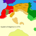
English: Legends:
 
Eyalet of Algiers
 
Vassal States of the Eyalet of Algiers
 
Vassal region or under the influence of the Eyalet of Algiers
 
Capitals of the Beyliks
 
Other Ottoman Eyalets
 
Vassal States of the other Ottoman Eyalets
 
Vassal region or under the influence of the other Ottoman Eyalets
 
Sultanate of Morocco
 
Vassal region or under the influence of the Sultanate of Morocco
 
Bled el-Siba
 
Region mainly Tuareg
 
Predominantly nomadic or tribal regions of the Sahara
Français :
 
Eyalet d’Alger
 
Région vassale ou sous influence de l’Elayet d’Alger
 
États vassaux de l’Elayet d’Alger
 
Capitales des Beyliks
 
Autres Eyalets Ottomanes
 
États vassaux des autres Eyalets Ottomanes
 
Région vassale ou sous influence des autres Eyalets Ottomanes
 
Sultanat du Maroc
 
Région vassale ou sous influence du Sultanat du Maroc
 
Bled el-Siba
 
Région majoritairement Tourages
 
Régions majoritairement nomades ou tribales sahariens
English: Sources and Bibliography:
  • Mahfoud Bennoune, The Making of Contemporary Algeria, 1830-1987, Cambridge University Press, 2002
  • Charles Féraud, Histoire des sultans de Touggourt et du Sud Algérien, 2006,  162
  • Histoire de l'Afrique septentrionale, Ernest MERCIER
  • Voyage dans la Régence d’Alger, Dr. Shaw
  • Carte des Régences d’Alger et de Tunis selon Dr. Shaw
  • Historical Atlas of Islamic Word, Malise Ruthven and Azim Nanji
  • African History in Maps, Michael_Kwamena-Poh, John_Tosh and Richard Waller
  • History of the World Map, Peter Snow
  • Atlas of Islamic, Peter Sluglett and Andrew Currie
  • Histoire de l'Afrique du Nord : Des origines à 1830, JULIEN, Charles-André
  • Philip's atlas of world history, Patrick O'Brien
  • Work of Kayra Atakan (Qirim Xan’i) and his video « Türk Tarihi---History of Turks » ( https://www.youtube.com/watch?v=BwQINDPHbFk )
  • Tachirifat de l’Eyalet et Fondation de la Régence d’Alger, traduction du livre «غزوات عروج ‎وخير الدين » par Sander Rang et Ferdinand Denis
  • Les Collections de l’Histoire, n°45 et n°63
  • Atlas de l’Afrique, Le Jaguar 2009; divers cartes du site euratlas.net
  • Atlas historique: L'histoire du monde, Duby George
  • Revue Africaine
  • Recherche sur l’Algérie à l’époque ottomane, Lemnouar Menouche
  • Gens et choses de Colomb-Béchar (Sud Oranais) par L. Céard
  • Wikipédia, Wikimédia common...et sites affiliée
  • L’Histoire et le site lhistoire.fr et la carte https://www.lhistoire.fr/portfolio/carte-lempire-ottoman-xvie-xviiie-si%C3%A8cle
Datum
Zdroj Vlastní dílo Based on Euratlas Periodis Web - Map of Europe 1800 Southwest. euratlas.net. Retrieved on 2021-06-25.
Autor AtlasDzMapper

Licence

Já, držitel autorských práv k tomuto dílu, ho tímto zveřejňuji za podmínek následující licence:
w:cs:Creative Commons
uveďte autora zachovejte licenci
Dílo smíte:
  • šířit – kopírovat, distribuovat a sdělovat veřejnosti
  • upravovat – pozměňovat, doplňovat, využívat celé nebo částečně v jiných dílech
Za těchto podmínek:
  • uveďte autora – Máte povinnost uvést autorství, poskytnout odkaz na licenci a uvést, pokud jste provedli změny. Toho můžete docílit jakýmkoli rozumným způsobem, avšak ne způsobem naznačujícím, že by poskytovatel licence schvaloval nebo podporoval vás nebo vaše užití díla.
  • zachovejte licenci – Pokud tento materiál jakkoliv upravíte, přepracujete nebo použijete ve svém díle, musíte své příspěvky šířit pod stejnou nebo slučitelnou licencí jako originál.

Popisky

Přidejte jednořádkové vysvětlení, co tento soubor představuje
Eyalet Algeria in 1771

Historie souboru

Kliknutím na datum a čas se zobrazí tehdejší verze souboru.

(nejnovější | nejstarší) Ukázat (10 novějších | ) (10 | 20 | 50 | 100 | 250 | 500).
Datum a časNáhledRozměryUživatelKomentář
současná22. 3. 2021, 19:03Náhled verze z 22. 3. 2021, 19:031 034 × 834 (65 KB)M.BittonReverted to version as of 15:37, 23 December 2019 (UTC): Per COM:OVERWRITE. Revert one more time and you will be reported to the admins
22. 3. 2021, 19:02Náhled verze z 22. 3. 2021, 19:021 034 × 834 (69 KB)Mhd240Reverted to version as of 19:40, 21 March 2021 (UTC)
22. 3. 2021, 18:03Náhled verze z 22. 3. 2021, 18:031 034 × 834 (65 KB)M.BittonReverted to version as of 15:37, 23 December 2019 (UTC)
21. 3. 2021, 21:40Náhled verze z 21. 3. 2021, 21:401 034 × 834 (69 KB)Mhd240Bad map
23. 12. 2019, 17:37Náhled verze z 23. 12. 2019, 17:371 034 × 834 (65 KB)SouthPyrethreAdjust the Dar-El-Sultan province
9. 12. 2019, 22:08Náhled verze z 9. 12. 2019, 22:081 034 × 834 (65 KB)SouthPyrethreCorrection of cities locations
8. 12. 2019, 19:40Náhled verze z 8. 12. 2019, 19:401 034 × 834 (65 KB)SouthPyrethreAdjust
8. 12. 2019, 19:39Náhled verze z 8. 12. 2019, 19:391 034 × 1 024 (72 KB)SouthPyrethreAdd title.
8. 12. 2019, 19:38Náhled verze z 8. 12. 2019, 19:381 034 × 1 024 (64 KB)SouthPyrethreAdjust Frontier of Beylik according Algerians sources (and historians sources)
8. 12. 2019, 19:36Náhled verze z 8. 12. 2019, 19:361 034 × 1 024 (65 KB)SouthPyrethreAdd frontier of Beylik according to Dr. Shaw
(nejnovější | nejstarší) Ukázat (10 novějších | ) (10 | 20 | 50 | 100 | 250 | 500).

Tento soubor používá následující stránka:

Globální využití souboru

Tento soubor využívají následující wiki:

Metadata