Soubor:Eu cartogram.png
Větší rozlišení není k dispozici
Eu_cartogram.png (490 × 436 pixelů, velikost souboru: 10 KB, MIME typ: image/png)
| Tento soubor pochází z Wikimedia Commons. Níže jsou zobrazeny informace, které obsahuje jeho tamější stránka s popisem souboru. |
Popis
| Popis |
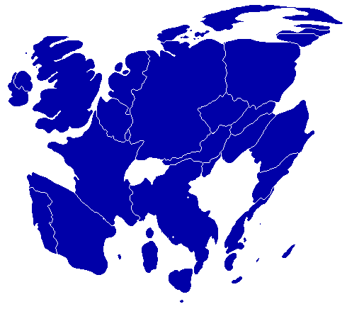
English: A cartogram depicting population distribution within the European Union at the member state level. Note how roughly half of all citizens within the EU live within the 4 largest member states: Germany, France, United Kingdom, and Italy. |
| Datum | |
| Zdroj | Self-made, referenced from a similiar cartogram at worldmapper.net |
| Autor | Geoilex |
Licence
| Já, autor tohoto díla, jej tímto uvolňuji jako volné dílo, a to celosvětově. V některých zemích to není podle zákona možné; v takovém případě: Poskytuji komukoli právo užívat toto dílo za libovolným účelem, a to bezpodmínečně s výjimkou podmínek vyžadovaných zákonem. |
Historie souboru
Kliknutím na datum a čas se zobrazí tehdejší verze souboru.
| Datum a čas | Náhled | Rozměry | Uživatel | Komentář | |
|---|---|---|---|---|---|
| současná | 27. 3. 2008, 11:54 | | 490 × 436 (10 KB) | Geoilex | {{Information |Description= A cartogram depicting population distribution within the European Union at the member state level. Note how roughly half of all citizens within the EU live within the 4 largest member states: Germany, France, United Kingdom, an |
| 27. 3. 2008, 11:47 |  | 490 × 436 (10 KB) | Geoilex | {{Information |Description= A cartogram depicting population distribution within the European Union and the member state level. Note how roughly half of all citizens within the EU live within the 4 largest member states: Germany, France, United Kingdom, a |
Využití souboru
Tento soubor používá následující stránka:
Globální využití souboru
Tento soubor využívají následující wiki:
- Využití na en.wikipedia.org
- Využití na es.wikipedia.org
- Využití na fr.wikipedia.org
- Využití na gl.wikipedia.org
- Využití na he.wikipedia.org
- Využití na it.wikipedia.org
- Využití na it.wikibooks.org
- Využití na nl.wikipedia.org
- Využití na pt.wikipedia.org
- Využití na sv.wikipedia.org
- Využití na uk.wikipedia.org