Soubor:Droysen - Oströmisches Reich.jpg
Původní soubor (3 025 × 2 000 pixelů, velikost souboru: 1,09 MB, MIME typ: image/jpeg)
| Tento soubor pochází z Wikimedia Commons. Níže jsou zobrazeny informace, které obsahuje jeho tamější stránka s popisem souboru. |
Popis
| Popis |
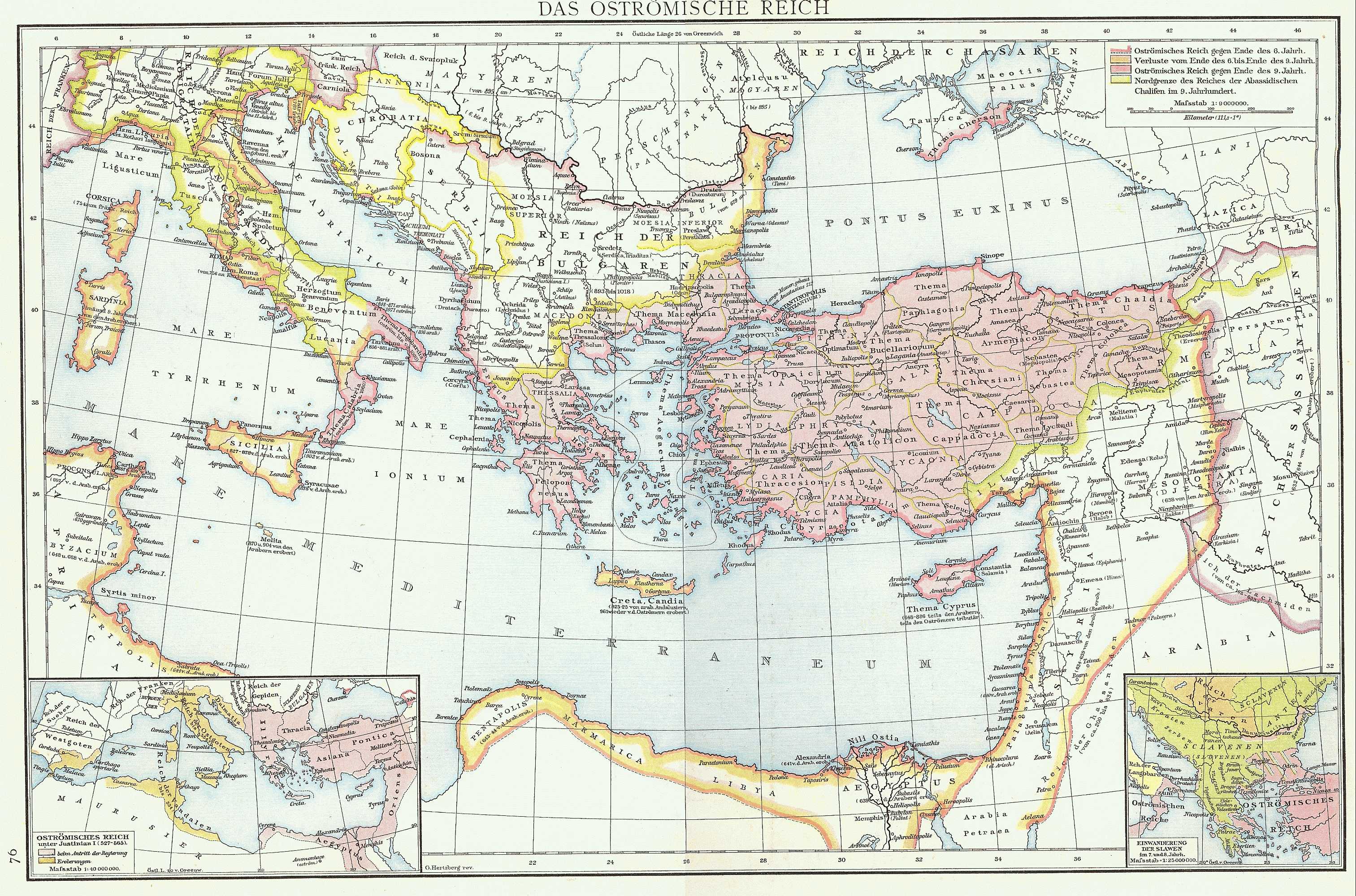
English: Map of the Byzantine Empire taken from G. Droysens Allgemeiner Historischer Handatlas, Verlag Velhagen und Klasing 1886
Deutsch: Karte des Byzantinischen (Oströmischen) Reiches aus G. Droysens Allgemeiner Historischer Handatlas, Verlag Velhagen und Klasing 1886 |
| Datum | |
| Zdroj | G. Droysens Allgemeiner Historischer Handatlas, Verlag Velhagen und Klasing, Bielefeld / Leipzig 1886 |
| Autor | Professor Gustav Droysen (Hg.), Professor G. Hertzberg (Zeichnung) |
Licence
|
Toto dílo je volné také v zemích, jejichž právní řád chrání majetková autorská práva po dobu života autora a 70 let po jeho smrti.
| |
| Bylo zjištěno, že u tohoto souboru nejsou známa žádná omezení daná autorským právem a právy s ním souvisejícími. | |
Historie souboru
Kliknutím na datum a čas se zobrazí tehdejší verze souboru.
| Datum a čas | Náhled | Rozměry | Uživatel | Komentář | |
|---|---|---|---|---|---|
| současná | 16. 11. 2022, 18:16 | | 3 025 × 2 000 (1,09 MB) | Gyalu22 | Reverted to version as of 10:14, 10 July 2009 (UTC) |
| 20. 9. 2016, 16:46 |  | 3 025 × 2 000 (2,31 MB) | Julieta39 | Better contrast | |
| 10. 7. 2009, 12:14 |  | 3 025 × 2 000 (1,09 MB) | Nikephoros | {{Information |Description={{en|1=Map of the Byzantine Empire taken from ''G. Droysens Allgemeiner Historischer Handatlas'', Verlag Velhagen und Klasing 1886}} {{de|1=Karte des Byzantinischen (Oströmischen) Reiches aus ''G. Droysens Allgemeiner Historisc |
Využití souboru
Tento soubor nepoužívá žádná stránka.
Globální využití souboru
Tento soubor využívají následující wiki:
- Využití na als.wikipedia.org
- Využití na ar.wikipedia.org
- Využití na de.wikipedia.org
- Využití na en.wikipedia.org
- Využití na es.wikipedia.org
- Využití na fr.wikipedia.org
- Využití na he.wikipedia.org
- Využití na id.wikipedia.org
- Využití na it.wikipedia.org
- Využití na la.wikipedia.org
- Využití na mk.wikipedia.org
- Využití na nl.wikipedia.org
- Využití na pt.wikipedia.org
- Využití na ro.wikipedia.org
- Využití na ru.wikipedia.org
- Využití na tr.wikipedia.org
- Využití na uk.wikipedia.org
- Využití na zh.wikipedia.org