Soubor:Distribution of Indigenous Peoples in the Americas.svg

Velikost tohoto PNG náhledu tohoto SVG souboru: 600 × 600 pixelů. Jiná rozlišení: 240 × 240 pixelů | 480 × 480 pixelů | 768 × 768 pixelů | 1 024 × 1 024 pixelů | 2 048 × 2 048 pixelů | 3 200 × 3 200 pixelů.
Původní soubor (soubor SVG, nominální rozměr: 3 200 × 3 200 pixelů, velikost souboru: 2,13 MB)
| Tento soubor pochází z Wikimedia Commons. Níže jsou zobrazeny informace, které obsahuje jeho tamější stránka s popisem souboru. |
Popis
| Popis |
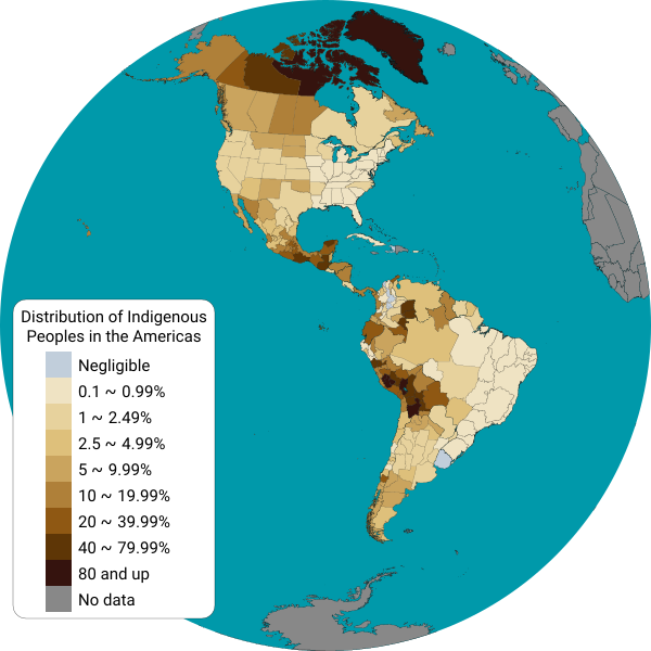
English: This map displays the distribution of indigenous people from each country in the Americas. Detailed information is displayed for Canadian provinces, U.S. states, Mexican states, Brazilian states and Chilean regions.
Map shapes from Natural Earth data, projected into a Lambert Azimuthal Equal-Area projection using a Python script. Data sources:
Español: Este mapa muestra el porcentaje de población indígena por cada país de América. Se muestra información detallada para las provincias de Canadá, los estados de los Estados Unidos, los estados de México, los estados de Brasil, los departamentos del Perú y de Bolivia, las provincias de la Argentina, y las regiones de Chile. |
| Datum | |
| Zdroj | Vlastní dílo |
| Autor | Locoluis |
Licence
Já, držitel autorských práv k tomuto dílu, ho tímto zveřejňuji za podmínek následující licence:
Tento soubor podléhá licenci Creative Commons Uveďte autora-Zachovejte licenci 4.0 International
- Dílo smíte:
- šířit – kopírovat, distribuovat a sdělovat veřejnosti
- upravovat – pozměňovat, doplňovat, využívat celé nebo částečně v jiných dílech
- Za těchto podmínek:
- uveďte autora – Máte povinnost uvést autorství, poskytnout odkaz na licenci a uvést, pokud jste provedli změny. Toho můžete docílit jakýmkoli rozumným způsobem, avšak ne způsobem naznačujícím, že by poskytovatel licence schvaloval nebo podporoval vás nebo vaše užití díla.
- zachovejte licenci – Pokud tento materiál jakkoliv upravíte, přepracujete nebo použijete ve svém díle, musíte své příspěvky šířit pod stejnou nebo slučitelnou licencí jako originál.
Historie souboru
Kliknutím na datum a čas se zobrazí tehdejší verze souboru.
| Datum a čas | Náhled | Rozměry | Uživatel | Komentář | |
|---|---|---|---|---|---|
| současná | 7. 6. 2022, 04:03 | | 3 200 × 3 200 (2,13 MB) | DemonDays64 | Converted text to Roboto path for consistent display. Also deleted the NOR path and removed some of the tiny dots of islands from NW Hawaii -- more border than anything and the NOR object was right on the edge making it look weird |
| 16. 9. 2021, 18:34 |  | 3 200 × 3 200 (2,07 MB) | Abbasi786786 | 2020 US Census Update | |
| 8. 7. 2017, 20:53 |  | 3 200 × 3 200 (6,58 MB) | Locoluis | Colombia https://www.dane.gov.co/files/censo2005/etnia/sys/visibilidad_estadistica_etnicos.pdf | |
| 2. 5. 2016, 08:06 |  | 1 600 × 1 600 (6,4 MB) | Locoluis | Argentina | |
| 14. 3. 2016, 04:45 |  | 1 600 × 1 600 (6,4 MB) | Locoluis | Added data for Peru and Bolivia | |
| 29. 3. 2015, 07:38 |  | 1 600 × 1 600 (6,4 MB) | Locoluis | Broke Antarctica in the process... | |
| 29. 3. 2015, 06:56 |  | 1 600 × 1 600 (6,52 MB) | Locoluis | * Fixed Canada * Added lakes * Added Brazil data from http://www.ibge.gov.br/indigenas/indigena_censo2010.pdf * Added another color category. | |
| 29. 3. 2015, 03:50 |  | 1 600 × 1 600 (3,37 MB) | Locoluis | French Guiana, simplified redundant points, color scheme. | |
| 29. 3. 2015, 03:07 |  | 1 600 × 1 600 (8,43 MB) | Locoluis | There was a CSS rule that displayed all US, CA, MX and CA regional polygons after all others were hidden. It didn't work. | |
| 29. 3. 2015, 03:02 |  | 1 600 × 1 600 (8,43 MB) | Locoluis | Oops... |
Využití souboru
Tento soubor používá následující stránka:
Globální využití souboru
Tento soubor využívají následující wiki:
- Využití na ar.wikipedia.org
- Využití na ast.wikipedia.org
- Využití na be.wikipedia.org
- Využití na bg.wikipedia.org
- Využití na ca.wikipedia.org
- Využití na de.wikipedia.org
- Využití na en.wikipedia.org
- Využití na eo.wikipedia.org
- Využití na et.wikipedia.org
- Využití na fi.wikipedia.org
- Využití na fr.wikipedia.org
- Využití na fy.wikipedia.org
- Využití na ga.wikipedia.org
- Využití na he.wikipedia.org
- Využití na ia.wikipedia.org
- Využití na id.wikipedia.org
- Využití na ja.wikipedia.org
- Využití na ko.wikipedia.org
- Využití na ky.wikipedia.org
- Využití na mk.wikipedia.org
- Využití na oc.wikipedia.org
- Využití na pt.wikipedia.org
- Využití na ro.wikipedia.org
- Využití na rue.wikipedia.org
- Využití na sr.wikipedia.org
- Využití na szy.wikipedia.org
- Využití na tr.wikipedia.org
- Využití na vec.wikipedia.org
- Využití na vi.wikipedia.org
- Využití na www.wikidata.org
- Využití na zh.wikipedia.org