Soubor:Demis-kurils-russian names.png
Větší rozlišení není k dispozici
Demis-kurils-russian_names.png (663 × 462 pixelů, velikost souboru: 70 KB, MIME typ: image/png)
| Tento soubor pochází z Wikimedia Commons. Níže jsou zobrazeny informace, které obsahuje jeho tamější stránka s popisem souboru. |
Popis
| Popis |
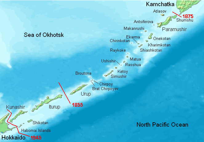
English: Kuril Islands overview map with current Russian names (English transliteration). Borders of Shimoda Treaty (1855) and Treaty of St. Petersburg (1875) shown in red. Currently all islands northeast of Hokkaido are administered by Russia. Note: Ushishir actually consists of 2 islands: Ryponkicha (northeast) and Yankicha (southwest).
Bahasa Indonesia: Peta yang menampilkan nama-nama pulau di Kepulauan Kuril dalam bahasa Rusia (transliterasi Inggris). Perbatasan dalam Traktat Shimoda (1855) dan Traktat Sankt-Peterburg (1875) ditunjukkan dalam warna merah. Sekarang semua pulau-pulau di timur laut Hokkaido dikuasai oleh Rusia. Catatan: Ushishir sebenarnya terdiri dari 2 pulau: Ryponkicha (timur laut) dan Yankicha (barat daya). |
| Datum | |
| Zdroj | Vlastní dílo |
| Autor | Hardscarf |
| Další verze |
|

Licence
This image is in the public domain because it came from the site https://www.demis.nl/products/web-map-server/examples/ and was released by the copyright holder. Permission is granted to copy, distribute and/or modify this map since it is based on free of copyright images from: www.demis.nl. See also approval email on de.wp and its clarification.
|
| This work has been released into the public domain by its copyright holder, www.demis.nl. This applies worldwide. V některých zemích to není podle zákona možné; v takovém případě: www.demis.nl poskytuje komukoli právo užívat toto dílo za libovolným účelem, a to bezpodmínečně s výjimkou podmínek vyžadovaných zákonem.
|
Historie souboru
Kliknutím na datum a čas se zobrazí tehdejší verze souboru.
| Datum a čas | Náhled | Rozměry | Uživatel | Komentář | |
|---|---|---|---|---|---|
| současná | 22. 5. 2008, 20:27 | | 663 × 462 (70 KB) | ChrisDHDR | added the border since 1945 |
| 23. 11. 2006, 22:00 |  | 663 × 462 (70 KB) | Hardscarf | Kuril Islands overviewmap with actual Russian names (English transliteration). Borders of Shimoda Treaty (1855) and Treaty of St. Petersburg (1875) shown in red. Currently all islands northwest of Hokkaido are administered by Russia. Note: Ushishir actua |
Využití souboru
Tento soubor používá následujících 5 stránek:
Globální využití souboru
Tento soubor využívají následující wiki:
- Využití na ace.wikipedia.org
- Využití na af.wikipedia.org
- Využití na ar.wikipedia.org
- Využití na az.wikipedia.org
- Využití na be.wikipedia.org
- Využití na bg.wikipedia.org
- Využití na br.wikipedia.org
- Využití na ca.wikipedia.org
- Využití na ckb.wikipedia.org
- Využití na da.wikipedia.org
- Využití na de.wikipedia.org
- Kurilen
- Vierte Kurilenstraße
- Kurilenstraße
- Zweite Kurilenstraße
- Nemuro-Straße
- Fries-Straße
- Luschin-Straße
- Krusenstern-Straße
- Jekaterina-Straße
- Boussole-Straße
- Kurilenstraßen
- Nadeschda-Straße
- 27. Armee (Japanisches Kaiserreich)
- 91. Division (Japanisches Kaiserreich)
- 5. Regionalarmee
- Benutzer:Bluemel1/Juli 1990
- Vorlage:Navigationsleiste Kurilenstraßen
- Využití na en.wikipedia.org
- Využití na en.wiktionary.org
- Využití na es.wikipedia.org
Zobrazit další globální využití tohoto souboru.