Soubor:Czechered landscape ESA359991.jpg

Původní soubor (2 599 × 1 299 pixelů, velikost souboru: 5,31 MB, MIME typ: image/jpeg)
| Tento soubor pochází z Wikimedia Commons. Níže jsou zobrazeny informace, které obsahuje jeho tamější stránka s popisem souboru. |
Popis
| Popis |
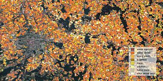
English: Different types of crops growing east of the Czech capital, Prague (left), are distinguished in this land cover classification image.
This crop map was created by combining over 1000 scenes from the Sentinel-1, Sentinel-2 and Landsat-8 satellites taken over the course of 2015. With its 13 spectral bands, the Sentinel-2 mission for Europe’s Copernicus programme is the first optical Earth observation mission of its kind to include three bands in the ‘red edge’, which provide key information on vegetation state. Sentinel-2 is designed to provide images that can be used to distinguish between different crop types as well as data on numerous plant indices, such as leaf area, leaf chlorophyll and leaf water – all essential to monitor plant growth accurately. This image was produced in collaboration with the European Commission (lead by the Joint Research Centre), the State Agricultural Intervention Fund of the Czech Republic and ESA. |
| Datum | |
| Zdroj | http://www.esa.int/spaceinimages/Images/2016/05/Czechered_landscape |
| Autor | European Space Agency |
| Svolení (Užití tohoto souboru) |
DUE Sentinel-2 for Agriculture project; contains modified Copernicus Sentinel data (2015),CC BY-SA 3.0 IGO |
| Title | Czechered landscape |
| Location | Czech Republic |
| Keywords | Agriculture; Crops |
| Set | Living Planet Symposium 2016 |
| Mission | Sentinel-1 |
| Activity | Observing the Earth |
Licence
- Dílo smíte:
- šířit – kopírovat, distribuovat a sdělovat veřejnosti
- upravovat – pozměňovat, doplňovat, využívat celé nebo částečně v jiných dílech
- Za těchto podmínek:
- uveďte autora – Máte povinnost uvést autorství, poskytnout odkaz na licenci a uvést, pokud jste provedli změny. Toho můžete docílit jakýmkoli rozumným způsobem, avšak ne způsobem naznačujícím, že by poskytovatel licence schvaloval nebo podporoval vás nebo vaše užití díla.
- zachovejte licenci – Pokud tento materiál jakkoliv upravíte, přepracujete nebo použijete ve svém díle, musíte své příspěvky šířit pod stejnou nebo slučitelnou licencí jako originál.
Historie souboru
Kliknutím na datum a čas se zobrazí tehdejší verze souboru.
| Datum a čas | Náhled | Rozměry | Uživatel | Komentář | |
|---|---|---|---|---|---|
| současná | 6. 5. 2017, 18:00 | | 2 599 × 1 299 (5,31 MB) | Fæ | == {{int:filedesc}} == {{information | description = {{en|1=Different types of crops growing east of the Czech capital, Prague (left), are distinguished in this land cover classification image. This crop map was created by combining over 1000 scenes fr... |
Využití souboru
Tento soubor používají následující 2 stránky: