Soubor:Conquest mexico 1519 21.png

Velikost tohoto náhledu: 800 × 399 pixelů. Jiná rozlišení: 320 × 160 pixelů | 640 × 320 pixelů | 1 300 × 649 pixelů.
Původní soubor (1 300 × 649 pixelů, velikost souboru: 1,45 MB, MIME typ: image/png)
| Tento soubor pochází z Wikimedia Commons. Níže jsou zobrazeny informace, které obsahuje jeho tamější stránka s popisem souboru. |
Popis

|
Tento soubor byl nahrazen souborem File:Ruta de Cortés.svg. Je doporučeno používat nový soubor. Důvod: The source of that other map is more recent and reliable.
|
| Popis |
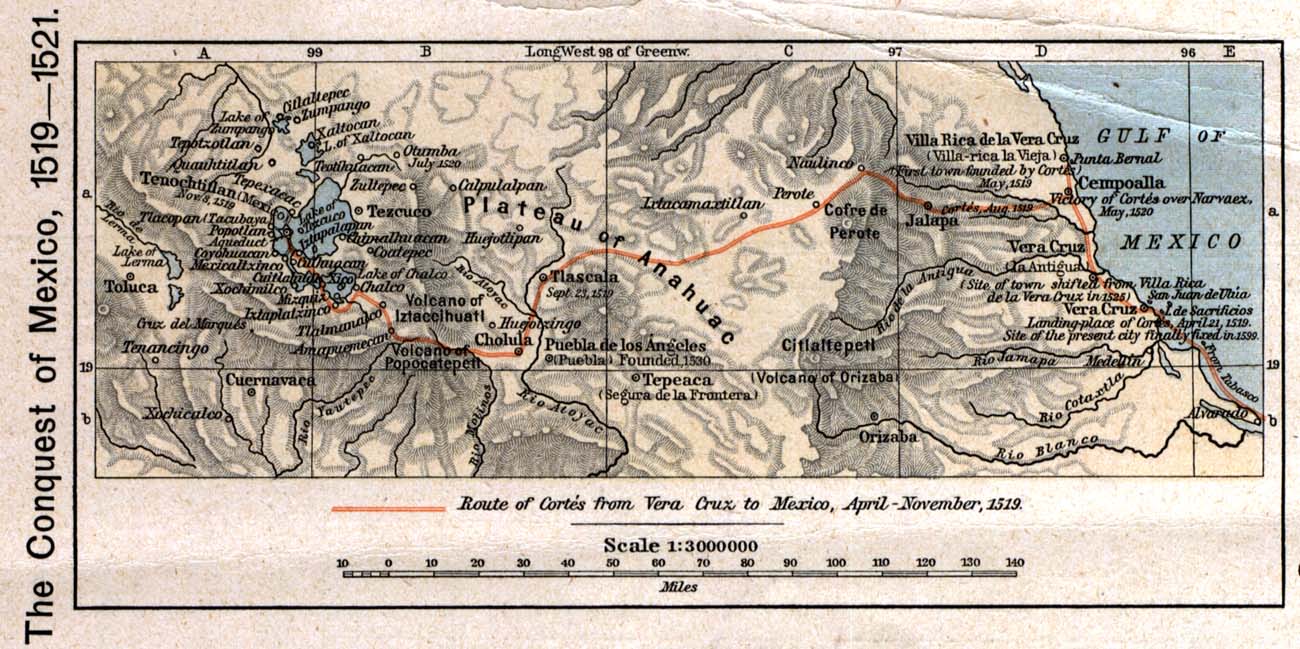
English: The 1519 to 1521 route of the Spanish conquest of the Aztec Empire — taken in Central Mexico by Hernando Cortés.
Français : La route de la conquête espagnole de l'Empire aztèque au centre de Mexique, comme suivi par Hernán Cortés de 1519 à 1521 |
| Datum | |
| Zdroj |
English: Scan from Historical Atlas by William R. Shepherd, New York, Henry Holt and Company, 1926 ed. Original image at the Perry-Castañeda Library Map Collection at the en:University of Texas at Austin website: http://www.lib.utexas.edu/maps/historical/shepherd/conquest_mexico_1519_21.jpg |
| Autor | William R. Shepherd |
| Svolení (Užití tohoto souboru) |
English: From the FAQ @ http://www.lib.utexas.edu/maps/faq.html
|
| Další verze |
|

Licence
This file may not have the correct information on its copyright status.
Notify the uploader with:
Items tagged with this template are sorted into Category:Items with disputed copyright information.
|
Toto dílo je ve Spojených státech volným dílem. To platí pro americká díla, jejichž autorská práva vypršela, často proto, že byla poprvé zveřejněna před 1. lednem 1929. Podívejte se na tuto stránku pro další vysvětlení.
|
 | |
 |
Tento obrázek nemusí být volným dílem mimo Spojené státy; to se týká zvláště těch zemí a oblastí, kde pro americká díla neplatí pravidlo kratší doby, jako jsou Kanada, Kontinentální Čína (ne Hong Kong nebo Macao), Německo, Mexiko a Švýcarsko. Tvůrce a rok publikace jsou nezbytné informace a musí být uvedeny. Viz Wikipedie:Autorské právo pro více informací.
|
Původní historie souboru
Původní stránka s popisem souboru byla zde. Všechna následující uživatelská jména odkazují na projekt en.wikipedia.
- 2006-12-18 21:20 Jengod 1300×649×8 (1520705 bytes) Scan from "Historical Atlas" by William R. Shepherd, New York, Henry Holt and Company, 1926 ed. Original image at the [http://www.lib.utexas.edu/maps/ Perry-Castañeda Library Map Collection] at the [[University of Texas at Austin]] website: http://www.l
Historie souboru
Kliknutím na datum a čas se zobrazí tehdejší verze souboru.
| Datum a čas | Náhled | Rozměry | Uživatel | Komentář | |
|---|---|---|---|---|---|
| současná | 17. 4. 2008, 22:12 | | 1 300 × 649 (1,45 MB) | File Upload Bot (Magnus Manske) | {{BotMoveToCommons|en.wikipedia}} {{Information |Description={{en|Scan from "Historical Atlas" by William R. Shepherd, New York, Henry Holt and Company, 1926 ed. Original image at the [http://www.lib.utexas.edu/maps/ Perry-Castañeda Library Map Collect |
Využití souboru
Tento soubor používá následující stránka:
Globální využití souboru
Tento soubor využívají následující wiki:
- Využití na azb.wikipedia.org
- Využití na ca.wikipedia.org
- Využití na en.wikipedia.org
- Využití na es.wikipedia.org
- Využití na fa.wikipedia.org
- Využití na ja.wikipedia.org
- Využití na ms.wikipedia.org
- Využití na pnb.wikipedia.org
- Využití na sl.wikipedia.org
- Využití na th.wikipedia.org
- Využití na tr.wikipedia.org
- Využití na uk.wikipedia.org
- Využití na ur.wikipedia.org
- Využití na vi.wikipedia.org
- Využití na www.wikidata.org