Soubor:Cold War border changes.png
Větší rozlišení není k dispozici
Cold_War_border_changes.png (599 × 436 pixelů, velikost souboru: 25 KB, MIME typ: image/png)
| Tento soubor pochází z Wikimedia Commons. Níže jsou zobrazeny informace, které obsahuje jeho tamější stránka s popisem souboru. |
Popis
| Popis |
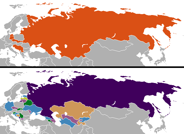
English: Changes in internationally recognized boundaries of countries after the end of the Cold War. Orange in the "before" map represents the territories as of 1991 which were affected. |
| Datum | |
| Zdroj | Vlastní dílo |
| Autor | Aivazovsky (talk) (Uploads) |
Licence
| Aivazovsky na projektu Wikipedie v jazyce angličtina, autor tohoto díla, jej uvolnil jako volné dílo, a to celosvětově. V některých zemích to není podle zákona možné; v takovém případě: Aivazovsky poskytuje komukoli právo užívat toto dílo za libovolným účelem, a to bezpodmínečně s výjimkou podmínek vyžadovaných zákonem. |
Colored by User:Aivazovsky from public domain Wikimedia Commons source.
Původní historie souboru
Původní stránka s popisem souboru byla zde. Všechna následující uživatelská jména odkazují na projekt en.wikipedia.
| Datum a čas | Rozměry | Uživatel | Komentář |
|---|---|---|---|
| 2009-12-11 10:57 | 599×436× (15723 bytes) | Ithanyx | Switched to most up-to-date template version. |
| 2008-07-19 07:01 | 599×436× (15610 bytes) | Hoshie | added the last change of the cold war: Kosovo |
| 2007-09-24 04:24 | 599×436× (20607 bytes) | Hoshie | fixed shading on two islands west of the Estonian SSR |
| 2007-02-27 02:21 | 599×436× (15749 bytes) | Aivazovsky | |
| 2006-10-10 06:35 | 599×436× (17502 bytes) | Hoshie | I have updated the map to include Montenegro, the last nation formed out of the cold war. |
| 2006-04-13 01:44 | 602×373× (14138 bytes) | Aivazovsky |
Historie souboru
Kliknutím na datum a čas se zobrazí tehdejší verze souboru.
| Datum a čas | Náhled | Rozměry | Uživatel | Komentář | |
|---|---|---|---|---|---|
| současná | 26. 11. 2023, 03:08 | | 599 × 436 (25 KB) | Ljutikecap2021 | Reverted to version as of 23:24, 21 June 2023 (UTC) |
| 18. 9. 2023, 22:52 |  | 599 × 436 (18 KB) | GPinkerton | Reverted to version as of 12:49, 19 March 2023 (UTC) Most of UN member states recognize Kosovo. Reverting pro-Serbian irredentist claims. | |
| 22. 6. 2023, 01:24 |  | 599 × 436 (25 KB) | Ljutikecap2021 | Reverted to version as of 21:56, 18 March 2023 (UTC) Most countries is nothing, if the UN doesn't recognize Kosovo as independent then it isn't. | |
| 19. 3. 2023, 14:49 |  | 599 × 436 (18 KB) | GPinkerton | Reverted to version as of 15:41, 11 January 2023 (UTC) Kosovo is recognized as independent by most countries | |
| 18. 3. 2023, 23:56 |  | 599 × 436 (25 KB) | Ljutikecap2021 | If we are going by international recognititon, then Kosovo is Serbia. | |
| 11. 1. 2023, 17:41 |  | 599 × 436 (18 KB) | GPinkerton | Reverted to version as of 20:15, 17 October 2022 (UTC) The map shows internationally recognized borders not Russian Lebensraum | |
| 11. 1. 2023, 16:52 |  | 599 × 436 (25 KB) | Ljutikecap2021 | If Kosovo is included, why shouldn't the disputed Russian territories in Eastern Ukraine, Transnistria and Artsakh be included? | |
| 26. 12. 2022, 04:59 |  | 599 × 436 (18 KB) | GPinkerton | Reverted to version as of 20:15, 17 October 2022 (UTC) Undiscussed and unhelpful pro-Russian changes | |
| 11. 12. 2022, 23:58 |  | 599 × 436 (25 KB) | Ljutikecap2021 | New Russian territories, Artsakh and Transnistria added. | |
| 4. 12. 2022, 23:08 |  | 599 × 436 (21 KB) | Savasampion | . |
Využití souboru
Tento soubor používá následující stránka:
Globální využití souboru
Tento soubor využívají následující wiki:
- Využití na af.wikipedia.org
- Využití na arz.wikipedia.org
- Využití na bn.wikipedia.org
- Využití na ca.wikipedia.org
- Využití na ckb.wikipedia.org
- Využití na cy.wikipedia.org
- Využití na el.wikipedia.org
- Využití na en.wikipedia.org
- History of Europe
- Irredentism
- Mikhail Gorbachev
- Nation state
- Nationalism
- Self-determination
- Eastern Bloc
- Secession
- Balkanization
- Cold War
- Revanchism
- Territorial evolution of Russia
- List of irredentist claims or disputes
- Revolutions of 1989
- List of national border changes (1914–present)
- Post–Cold War era
- Dissolution of the Soviet Union
- User:Falcaorib
- Využití na en.wikibooks.org
- Využití na es.wikipedia.org
- Využití na hu.wikipedia.org
- Využití na hy.wikipedia.org
- Využití na id.wikipedia.org
- Využití na ja.wikipedia.org
- Využití na kk.wikipedia.org
- Využití na ko.wikipedia.org
- Využití na mk.wikipedia.org
- Využití na ml.wikipedia.org
- Využití na pa.wikipedia.org
- Využití na pnb.wikipedia.org
- Využití na pt.wikipedia.org
- Využití na rm.wikipedia.org
- Využití na sl.wikipedia.org
- Využití na sr.wikipedia.org
- Využití na ta.wikipedia.org
- Využití na ur.wikipedia.org
- Využití na zh-classical.wikipedia.org
- Využití na zh.wikipedia.org
Zobrazit další globální využití tohoto souboru.