Soubor:Canyons off LA.jpg
Větší rozlišení není k dispozici
Canyons_off_LA.jpg (720 × 511 pixelů, velikost souboru: 35 KB, MIME typ: image/jpeg)
| Tento soubor pochází z Wikimedia Commons. Níže jsou zobrazeny informace, které obsahuje jeho tamější stránka s popisem souboru. |
Popis
| Popis |
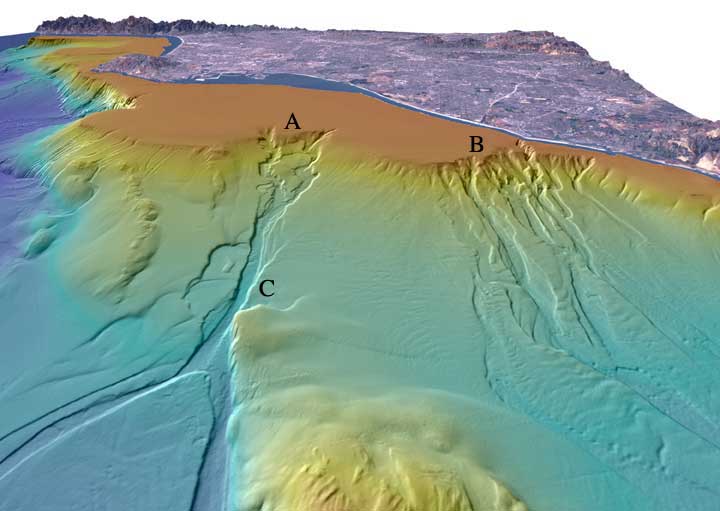
English: "Perspective view looking north over the San Gabriel (A) and Newport (B) submarine canyons. The distance across the bottom of the image is about 17 km with a vertical exaggeration of 6x. Both canyons formed when the San Gabriel River and the Santa Ana River flowed out across the Los Angeles Basin and offshore shelf when it was exposed during lower eustatic sea level. Newport Canyon begins less than 360 m from shore at the north end of Newport Harbor and is composed of individual channels that braid down the slope over a width of about 9 km. San Gabriel Canyon begins as a series of channels that join together midway down the slope and then split into two channels at the base of the slope. The width of San Gabriel Canyon at "C" is 815 m and incises about 25 m into the slope. Lasuen Knoll can be seen in the forground." |
| Datum | |
| Zdroj | [1] |
| Autor | United States Geological Survey |
Licence
Tento soubor je volné dílo, protože obsahuje materiály pocházející od United States Geological Survey (USGS), agentury Ministerstva vnitra USA. Pro bližší informaci vizte oficiální licenční pravidla USGS (anglicky).
|
Historie souboru
Kliknutím na datum a čas se zobrazí tehdejší verze souboru.
| Datum a čas | Náhled | Rozměry | Uživatel | Komentář | |
|---|---|---|---|---|---|
| současná | 27. 1. 2012, 00:11 | | 720 × 511 (35 KB) | Mikenorton |
Využití souboru
Tento soubor používá následující stránka:
Globální využití souboru
Tento soubor využívají následující wiki:
- Využití na ar.wikipedia.org
- Využití na ca.wikipedia.org
- Využití na en.wikipedia.org
- Využití na en.wikiversity.org
- Využití na es.wikipedia.org
- Využití na gl.wikipedia.org
- Využití na it.wikipedia.org
- Využití na it.wikibooks.org
- Využití na it.wikiversity.org
- Využití na ja.wikipedia.org
- Využití na ka.wikipedia.org
- Využití na mk.wikipedia.org
- Využití na ru.wikipedia.org
- Využití na tr.wikipedia.org
- Využití na uk.wikipedia.org