Soubor:British main lines railway diagram.png

Velikost tohoto náhledu: 421 × 599 pixelů. Jiná rozlišení: 168 × 240 pixelů | 337 × 480 pixelů | 539 × 768 pixelů | 719 × 1 024 pixelů | 2 464 × 3 508 pixelů.
Původní soubor (2 464 × 3 508 pixelů, velikost souboru: 558 KB, MIME typ: image/png)
| Tento soubor pochází z Wikimedia Commons. Níže jsou zobrazeny informace, které obsahuje jeho tamější stránka s popisem souboru. |

|
K tomuto obrázku existuje vektorová verze (v SVG). Pokud je lepší, používejte raději tu.
File:British main lines railway diagram.png → File:British main lines railway diagram.svg
Podrobnější informace o vektorové grafice najdete na stránce Commons:Transition to SVG. Také si můžete přečíst informace o podpoře formátu SVG v MediaWiki. |
 |
Popis
| Popis |
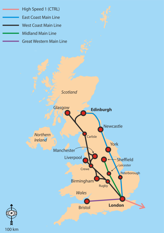
English: Simple overview map of the WCML, ECML, Midland Main Line and CTRL. |
| Datum | |
| Zdroj | Vlastní dílo |
| Autor | Classical geographer |
Background is File:Uk_outline_map.png; ECML and WCML are based on File:Uk outline map with ECML railway.PNG and File:Uk outline map with WCML railway.PNG.
Licence
Já, držitel autorských práv k tomuto dílu, ho tímto zveřejňuji za podmínek následující licence:
Tento soubor podléhá licenci Creative Commons Uveďte autora-Zachovejte licenci 3.0 Unported
- Dílo smíte:
- šířit – kopírovat, distribuovat a sdělovat veřejnosti
- upravovat – pozměňovat, doplňovat, využívat celé nebo částečně v jiných dílech
- Za těchto podmínek:
- uveďte autora – Máte povinnost uvést autorství, poskytnout odkaz na licenci a uvést, pokud jste provedli změny. Toho můžete docílit jakýmkoli rozumným způsobem, avšak ne způsobem naznačujícím, že by poskytovatel licence schvaloval nebo podporoval vás nebo vaše užití díla.
- zachovejte licenci – Pokud tento materiál jakkoliv upravíte, přepracujete nebo použijete ve svém díle, musíte své příspěvky šířit pod stejnou nebo slučitelnou licencí jako originál.
Historie souboru
Kliknutím na datum a čas se zobrazí tehdejší verze souboru.
| Datum a čas | Náhled | Rozměry | Uživatel | Komentář | |
|---|---|---|---|---|---|
| současná | 6. 9. 2016, 19:29 | | 2 464 × 3 508 (558 KB) | Rob984 | Showing all of Ireland but not even part of France is odd. Especially considering there are UK-France high speed routes. |
| 6. 9. 2016, 06:48 |  | 2 503 × 3 627 (849 KB) | Classical geographer | Added Western Main Line. Decreased font size of junctions. Note the map is still intended for a quick overview, perhaps at the top of an article. | |
| 22. 7. 2010, 09:29 |  | 1 333 × 1 777 (188 KB) | Classical geographer | Chester should have been Crewe. | |
| 21. 7. 2010, 21:17 |  | 1 666 × 2 221 (904 KB) | Classical geographer | Resized, because was over 12.5 million pixels. | |
| 21. 7. 2010, 21:15 |  | 3 333 × 4 444 (600 KB) | Classical geographer | {{Information |Description={{en|1=Simple overview map of the WCML, ECML, Midland Main Line and CTRL.}} |Source={{own}} |Author=Classical geographer |Date=2010-07-21 |Permission= |other_versions= }} Background is [[:File:Uk_ou |
Využití souboru
Tento soubor nepoužívá žádná stránka.
Globální využití souboru
Tento soubor využívají následující wiki:
- Využití na en.wikipedia.org
- Využití na fa.wikipedia.org
- Využití na it.wikipedia.org
- Využití na ja.wikipedia.org
- Využití na nl.wikipedia.org
- Využití na no.wikipedia.org
- Využití na pnb.wikipedia.org
- Využití na pt.wikipedia.org
- Využití na ru.wikipedia.org
- Využití na ur.wikipedia.org
- Využití na zh.wikipedia.org