Soubor:Brazil-16-map.jpg
Brazil-16-map.jpg (379 × 516 pixelů, velikost souboru: 277 KB, MIME typ: image/jpeg)
| Tento soubor pochází z Wikimedia Commons. Níže jsou zobrazeny informace, které obsahuje jeho tamější stránka s popisem souboru. |
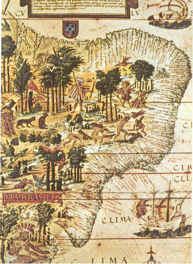
| Popis | Map of Brazil in the Miller Atlas of 1519. Scan from 《社会历史博物馆》 ISBN 7-5347-1397-8 "社会历史博物馆" / "Social Historical Museum" 16世纪巴西的地图 / The map of Brasil in 16th century 1519年葡萄牙人绘制 / Issued in Portugal in 1519 |
| Datum | Brazil 1500 |
| Zdroj | scan from 《社会历史博物馆》 ISBN 7-5347-1397-8 |
| Autor | 《社会历史博物馆》 |
| Další verze |
 |
|
Toto dílo je volné také v zemích, jejichž právní řád chrání majetková autorská práva po dobu života autora a 70 let po jeho smrti.
| |
| Bylo zjištěno, že u tohoto souboru nejsou známa žádná omezení daná autorským právem a právy s ním souvisejícími. | |
Historie souboru
Kliknutím na datum a čas se zobrazí tehdejší verze souboru.
| Datum a čas | Náhled | Rozměry | Uživatel | Komentář | |
|---|---|---|---|---|---|
| současná | 6. 6. 2005, 21:00 | | 379 × 516 (277 KB) | Shizhao | scan from 《社会历史博物馆》 ISBN 7-5347-1397-8 16世纪巴西的地图 1519年葡萄牙人绘制 {{PD}} |
Využití souboru
Tento soubor používají následující 2 stránky:
Globální využití souboru
Tento soubor využívají následující wiki:
- Využití na af.wikipedia.org
- Využití na ar.wikipedia.org
- Využití na azb.wikipedia.org
- Využití na ba.wikipedia.org
- Využití na bg.wikipedia.org
- Využití na ca.wikipedia.org
- Využití na da.wikipedia.org
- Využití na de.wikipedia.org
- Využití na el.wikipedia.org
- Využití na en.wikipedia.org
- Využití na en.wikibooks.org
- Využití na eo.wikipedia.org
- Využití na es.wikipedia.org
- Využití na fa.wikipedia.org
- Využití na fr.wikipedia.org
Zobrazit další globální využití tohoto souboru.