Soubor:Bravo fallout2.png
Velikost tohoto náhledu: 800 × 364 pixelů. Jiná rozlišení: 320 × 146 pixelů | 928 × 422 pixelů.
Původní soubor (928 × 422 pixelů, velikost souboru: 23 KB, MIME typ: image/png)
| Tento soubor pochází z Wikimedia Commons. Níže jsou zobrazeny informace, které obsahuje jeho tamější stránka s popisem souboru. |
Popis
| Popis |
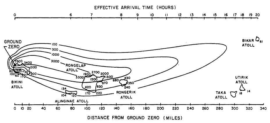
English: Path of nuclear fallout plume after U.S. nuclear weapons test Bravo (yield 15 Mt) on Bikini Atoll. It is the single worst contamination accident in U.S. nuclear history. The test was part of the Operation Castle. The Bravo event was an experimental thermonuclear device surface event. The numbers correspond with estimated total (accumulated) dose contours (rad).
Suomi: Ydinkoe Bravon (räjähdysvoima 15 Mt) radioaktiivinen laskeuma. Bravo testi on Yhdysvaltojen pahin ydinonnettomuus. Testi oli osa Operaatio Castlea. Bravo räjäytys oli kokeellinen fuusioreaktioon perustuva pintaräjäytys Bikinin atollilla. Kuvan numerot kuvaavat arvioituja kertyneen kokonaislaskeuman rajoja (rad). |
| Datum | |
| Zdroj | Samuel Glasstone and Phillip J. Dolan, eds., The Effects of Nuclear Weapons, 3rd. edn. (Washington, D.C.: DOD and DOE, 1977): 437. [Gamma doses are Roentgens from arrival time to 96 hours (4 days) after detonation, outside on land. Glasstone and Dolan mention that because data from the ocean was not obtained in this particular test, Bravo, the fallout contours to the north of the islands are uncertain and some other fallout patterns for the same test ascribe the high levels measured on Rongelap to a "hotspot" of the sort measured in the ocean downwind in later tests. |
| Autor | United States Department of Energy |
| Další verze |
 |

|
Tento obrázek (skupina graph) by měl být vytvořen pomocí vektorové grafiky jako SVG soubor. To má několik výhod; podrobnosti najdete na stránce Commons:Media for cleanup. Je-li SVG verze tohoto obrázku již k dispozici, prosím nahrajte ji. Po nahrání nahraďte tuto šablonu šablonou {{Vector version available|jméno nového obrázku.svg}}.
|
Licence
| This image is a work of a United States Department of Energy (or predecessor organization) employee, taken or made as part of that person's official duties. As a work of the U.S. federal government, the image is in the public domain.
Please note that national laboratories operate under varying licences and some are not free. Check the site policies of any national lab before crediting it with this tag.
|

|
Historie souboru
Kliknutím na datum a čas se zobrazí tehdejší verze souboru.
| Datum a čas | Náhled | Rozměry | Uživatel | Komentář | |
|---|---|---|---|---|---|
| současná | 10. 12. 2005, 19:25 | | 928 × 422 (23 KB) | Fastfission~commonswiki | Image of nuclear fallout dispersal from the Castle Bravo nuclear test, 28 Feb 1954. ==Licensing== *Source: Samuel Glasstone and Phillip J. Dolan, eds., ''The Effects of Nuclear Weapons'', 3rd. edn. (Washington, D.C.: DOD and DOE, 1977): 437. {{PD-USG |
Využití souboru
Tento soubor používá následující stránka:
Globální využití souboru
Tento soubor využívají následující wiki:
- Využití na de.wikipedia.org
- Využití na en.wikipedia.org
- Využití na en.wikiquote.org
- Využití na es.wikipedia.org
- Využití na fr.wikipedia.org
- Využití na hr.wikipedia.org
- Využití na it.wikipedia.org
- Využití na ja.wikipedia.org
- Využití na ko.wikipedia.org
- Využití na la.wikipedia.org
- Využití na pl.wikipedia.org
- Využití na pt.wikipedia.org
- Využití na ru.wikipedia.org
- Využití na sh.wikipedia.org
- Využití na sk.wikipedia.org
- Využití na sl.wikipedia.org
- Využití na sr.wikipedia.org
- Využití na te.wikipedia.org
- Využití na uk.wikipedia.org
- Využití na zh.wikipedia.org