Soubor:Ban Jelačić Square at night (13023889593).jpg

Velikost tohoto náhledu: 800 × 514 pixelů. Jiná rozlišení: 320 × 206 pixelů | 640 × 411 pixelů | 1 024 × 658 pixelů | 1 280 × 822 pixelů | 2 560 × 1 645 pixelů | 4 179 × 2 685 pixelů.
Původní soubor (4 179 × 2 685 pixelů, velikost souboru: 1,05 MB, MIME typ: image/jpeg)
| Tento soubor pochází z Wikimedia Commons. Níže jsou zobrazeny informace, které obsahuje jeho tamější stránka s popisem souboru. |
.jpg)
Popis
| Popis |
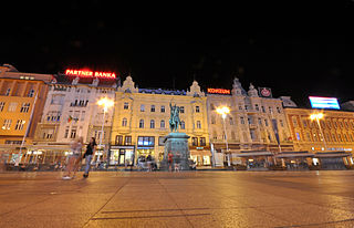
Ban Jelačić Square is the central square of the city of Zagreb, Croatia, named after ban Josip Jelačić. The official name is Trg bana Jelačića. It is colloquially referred to as Jelačić plac (derived from Platz, the German word for square or plaza) or simply Trg ("the square"). It is located below Zagreb's old city cores Gradec and Kaptol and directly south of the Dolac Market on the intersection of Ilica from the west, Radićeva Street from the northwest, the small streets Splavnica and Harmica from the north, Bakačeva Street from the northeast, Jurišićeva Street from the east, Praška Street from the southeast and Gajeva Street from the southwest. It is the center of the Zagreb Downtown pedestrian zone [Wikipedia.org] |
| Datum | |
| Zdroj | Ban Jelačić Square at night |
| Autor | Jorge Láscar from Australia |
| Pozice fotografa | | Tento snímek a mnohé další na: OpenStreetMap |
|---|
.jpg¶ms=045.813019_N_0015.977367_E_globe:Earth_type:camera_source:Flickr_&language=cs)
Licence
Tento soubor podléhá licenci Creative Commons Uveďte autora 2.0 Generic
- Dílo smíte:
- šířit – kopírovat, distribuovat a sdělovat veřejnosti
- upravovat – pozměňovat, doplňovat, využívat celé nebo částečně v jiných dílech
- Za těchto podmínek:
- uveďte autora – Máte povinnost uvést autorství, poskytnout odkaz na licenci a uvést, pokud jste provedli změny. Toho můžete docílit jakýmkoli rozumným způsobem, avšak ne způsobem naznačujícím, že by poskytovatel licence schvaloval nebo podporoval vás nebo vaše užití díla.
| This image was originally posted to Flickr by Jorge Lascar at https://www.flickr.com/photos/8721758@N06/13023889593. It was reviewed on 2. dubna 2014 by FlickreviewR and was confirmed to be licensed under the terms of the cc-by-2.0. |
Historie souboru
Kliknutím na datum a čas se zobrazí tehdejší verze souboru.
| Datum a čas | Náhled | Rozměry | Uživatel | Komentář | |
|---|---|---|---|---|---|
| současná | 2. 4. 2014, 08:27 | | 4 179 × 2 685 (1,05 MB) | Russavia | Transferred from Flickr |
Využití souboru
Tento soubor nepoužívá žádná stránka.
.jpg)